

 The Earth Observation community is growing and people are starting to find each other on online social platforms. That is why, in March 2021, Steven Ramage, Keiko Nomura and Flávia Mendes opened a room at ClubHouse platform in the Earth Observation club to discuss EO for good from the private sector perspective. The result was very interesting and it led to more topics that the community would like to discuss. Therefore, we had the idea to continue it, but this time on Spaces/Twitter APP. In this second meeting, we discussed supply chain in the context of Earth Observation. This meeting’s expert guests were Arjen Vrielink (Satelligence), Bernardo Rudorff (Agrosatélite) and Sarah Middlemiss (Ecometrica) and shared their experiences and views on the subject.
A nice, informal chat sprouted. In addition to the guests’ examples of the use of Earth Observation in supply chains that mostly work in the commodities sector in developing countries, listeners also chipped in by raising technical and commercial aspects.
On the technical side, the challenges of centralizing high accuracy data into a single database are ample. The Global Forest Watch (GFW) [1] data has a spatial resolution of 30 meters and is available all over the world. In this case, it is necessary to consider the possible generalization errors; especially in transition zones that have a great floristic variability, this can ‘confuse’ algorithms in the identification of forest or non-forest. For this, local data such as the PRODES [2] deforestation data of the Amazon processed by the National Institute for Space Research (INPE) can contribute to overcome this challenge, since the algorithms are trained specifically with the floristic variability of this specific region, such as the Amazon Forest. Additionally, PRODES data are very useful in monitoring the conversion of native vegetation such as in the case of the Soy Moratorium [3]. This discussion leads us to another aspect of the technical challenges: what is deforestation? Is deforestation clear cut, forest disturbance, selective logging or plantation replanting? The definition of these terms by each institution or company influences analysis results.
Apart from differences in datasets and definitions like between PRODES and GFW, vegetation mapping faces other challenges. Take, for example, the case of cocoa mapping. Influence of the overlap of larger trees in relation to the canopy cover challenges mapping cocoa plantations. Some ideas to overcome this challenge have emerged, such as the use of ‘fuzzy’ gradients rather than sharp boundaries resulting from probabilistic algorithms.
If we think about the commercial aspects that may drive the use of Earth Observation in the supply chain, we can start with the incentives why a company should or should not do this type of analysis. Government regulations? Fines? Marketing&PR (green washing)? Stockholder value? Changing consumer behavior? Or a combination of all these options? It is important to realize that EO companies should understand the pains and gains of supply chain stakeholders that their products or services address.
Additionally, there is the question of ethics and the limitations of products that EO companies can offer in the supply chain. One of the guests asked the relevant question: if your client is asking for a shiny map you could deliver but not at scale (temporal, spatial), do you deliver the shiny map? Unconditionally? Decisions like this are important as part of the work a society must do to reduce the impacts of climate change. Here we see that the challenges in the EO community are not only technical but also ethical, economic and maybe even political. How do you manage expectations? Not only in the short run, but also in the long run.
The discussion showed that much has been achieved, especially with regard to the volume of different earth observation data. However, there are also many challenges still to overcome related to the accuracy of Earth Observation and field data. Additionally, there has to be more communication between the beginning, middle and end of the supply chain. This communication could be facilitated by EO derived products and services to create an evidence based area of discourse.
Stay tuned on these twitter accounts (@Steven_Ramage @Keiko_geo and @flasmendes) for more information on upcoming meetings.
Links:
Did you like the article? Read more and subscribe to our monthly newsletter!

#


Next article

This StoryMap (first published on MapAction’s blog in November 2020) explains how some of the over 200 maps international humanitarian charity MapAction created following Hurricanes Eta and Iota in Central America in November 2020 were used to help get aid to people that needed it. Click here to view it in full screen.
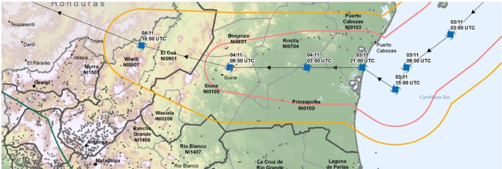
In November 2020, a three-person MapAction team travelled to Guatemala following extreme flooding and catastrophic landslides in 12 of 22 of the country’s administrative departments. This was caused by two severe hurricanes hitting the Central American region in quick succession. Around 6 million people were affected in Honduras, Guatemala, and Nicaragua and 590,000 had to leave their homes.
Ten departments of Guatemala declared a state of emergency and the government requested international assistance.
The devastating storms came on the back of social and economic hardship caused and exacerbated by COVID, unemployment and population displacement. The flooding caused widespread destruction of crops and livestock and around 5,000 wells were contaminated.
MapAction’s assistance was requested by the UN’s Office for Coordination of Humanitarian Affairs (OCHA). We helped to gather and map information about the evolving situation on the ground. This included mapping storm tracks, flood extents, building damage, affected populations and information about what assistance humanitarian teams were already providing in different locations so that gaps could be identified and rapidly addressed.
In addition to the Guatemalan team, a five-person MapAction team was already providing full emergency support remotely to OCHA’s Regional Office for Latin America and the Caribbean (ROLAC) from 6 November following Hurricane Eta, while another team member had been seconded to ROLAC full time from September 2020 to assist with hurricane preparedness and other humanitarian issues across the region.
MapAction volunteer Emerson Tan filmed a vlog from the airport on his way back from Guatemala:
Did you like the article? Read more and subscribe to our monthly newsletter!