
A brief history of time
Geoawesomeness – The Location-based blog: The journey that started seven years ago as a blog about geospatial technology and everything awesome around it. What started out as a blog of passion for maps by a graduate student from Warsaw – has certainly come a long way. The site now boasts over 1800 blogs written by 69 Geogeeks from across 6 continents. We’re only missing a post from Antarctica to give us all 7 continents!
Over the course of the years, Geoawesomeness has slowly evolved into a platform for passionate GeoGeeks to read about the latest and the greatest in the geo-industry and to spread the awesomeness. One of our proudest days at Geoawesomeness was when Jack Dangermond, a legend, and stalwart of the industry wrote for us, sharing his views on where the industry is headed (Five GIS Trends Changing the World). That’s when we realised that Geoawesomeness wasn’t going to be “just a blog” anymore!

Many things have changed over the years, but if there is one thing that we as a team are very proud of; it is that since day one, we are still just as passionate about discovering and sharing the connection between location and technology. As the world never stops spinning, we never stop our quest for the new. Today, we are thrilled to announce that after months of planning and discussion (in other words, endless Skype calls, poorly drawn diagrams and caffeine powered evenings), we are adding a new dimension to Geoawesomeness – “The Next Geo”.
The Next Geo
Globally, There’s an ever-increasing number of companies and individuals who are changing the face of the geo-industry.
Almost five decades ago, a young landscape architect together with his wife, founded a land-use consulting firm – Esri, which is today a GIS company with over 300,000 customers, and 1 billion dollars in revenue! In the early 2000s, two Danish brothers (and software developers) changed the way that we navigate by creating what we today refer to as Google Maps. Even more recently, a music producer decided that our current addressing system needs a radical overhaul, coming up with an amazing yet straightforward solution – What3Words. Boundless, formerly OpenGeo, showed the industry that it is possible to have a successful business building products around open source technologies before the rest of the tech world started investing heavily in that direction. Mapbox has transformed itself into a location data platform for developers and is now leading the way in mapping the world live; Collecting over 250 million miles of anonymized location data daily (raising some serious capital in the process). Planet, Carto, PrecisionHawk, Mapillary, Motive.io are all doing some fantastic work. One cannot forget to mention – DigitalGlobe, Leica, Pitney Bowes, TomTom, HERE and Trimble among others who have established successful businesses that have survived the test of time for decades. The list is a long one!

The Next Geo is all about finding these people and companies – unearthing their stories, discovering their products, understanding their business models and celebrating their success! Our vision for “The Next Geo” is to provide you with company and product insights, meaning; and of course – awesomeness!
Defining the Geo-industry
When we say Geo – we mean everything that has to do with location data. Just to take an example – Is Uber a geospatial company? Hell yeah, without maps and routing algorithms Uber wouldn’t exist. Uber isn’t just using maps and routing algorithms as tools; they are actively developing new “geo” tools that help them to transform the transportation industry, albeit controversially (Related: Uber Engineering blog post about Maps, Machine Learning, and AI).
The Next Geo is about uncovering the connection between Location and Technology where ever it may exist and to list a few of them (alphabetically)
- Augmented reality
- Autonomous Driving
- Big data (Spatial)
- Blockchain, Decentralization
- Drones
- Image Processing, Remote Sensing, Computer Vision
- Location intelligence, Location data analytics
- Machine learning, AI
- Mobility as a service
- Smart cities, Internet of Things
- And many more….
What all of them have in common is – the spatial component.
We want “The Next Geo” not only to showcase exciting new technologies but also new business models. Even if you invented the wheel, you still have to market it right!
#TheNextGeo
We know it takes a village, and so we are thrilled to have your feedback, suggestions, and any leads you think should be featured on The Next Geo! Share with us, and we’ll share it with the world! You can reach us at info@geoawesomeness.com or via social media 🙂
Here’s to new beginnings and a happy Tamil new year 🙂
EDIT: You can read about all the startups that were featured under #TheNextSeries under this link.


#Business


Next article

Who needs Google Earth? Planet has released a breathtaking collection of satellite imagery of famous places around the world – but it’s nothing like what you have ever seen before. Unlike the flat or nadir topographic images we all are so familiar with, the pictures released by Planet have been captured at experimental off-angles, adding some amazing vertical depth to the landmass. The credit for these brilliant visuals goes to Planet’s constellation of 13 SkySats. Feast your eyes:
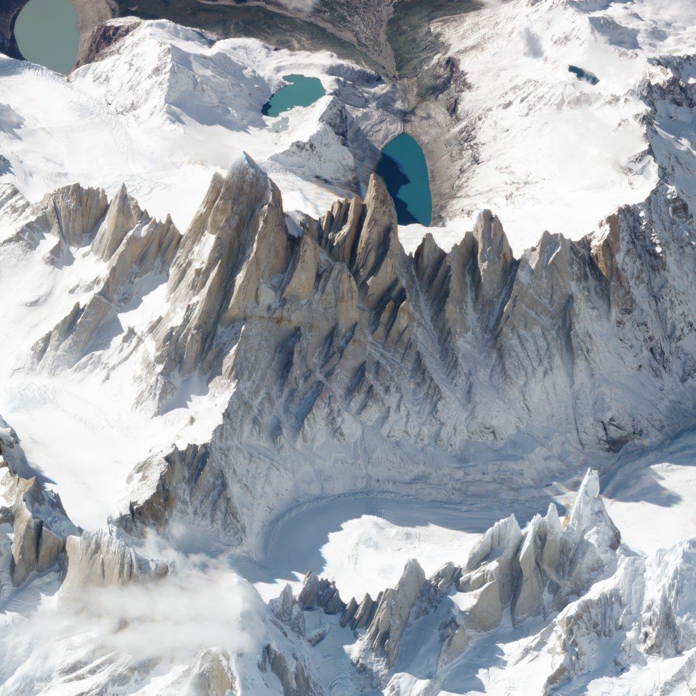
1) Monte Fitz Roy
Up first is a peak adored by the lovers of trekking and climbing, Monte Fitz Roy. The mountain on the border of Argentina and Chile looks like something from the window of an airplane when seen at this angle.
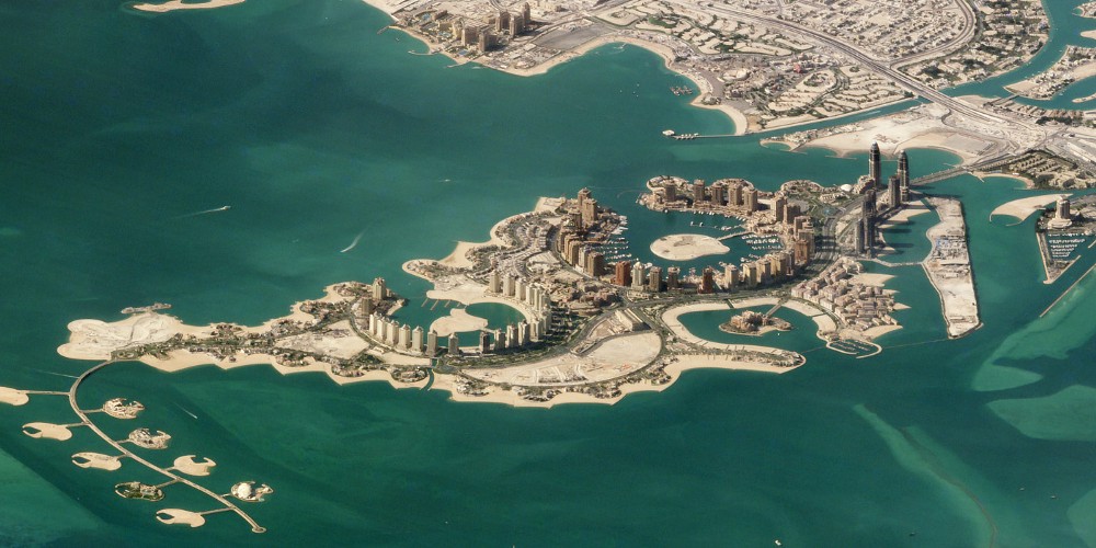
2) Doha, Qatar
The artificial island of the Pearl-Qatar in Doha, Qatar spans nearly 4 million square meters. The string of luxury residences and hotels is thronged by Mediterranean-style yacht-lined marinas.
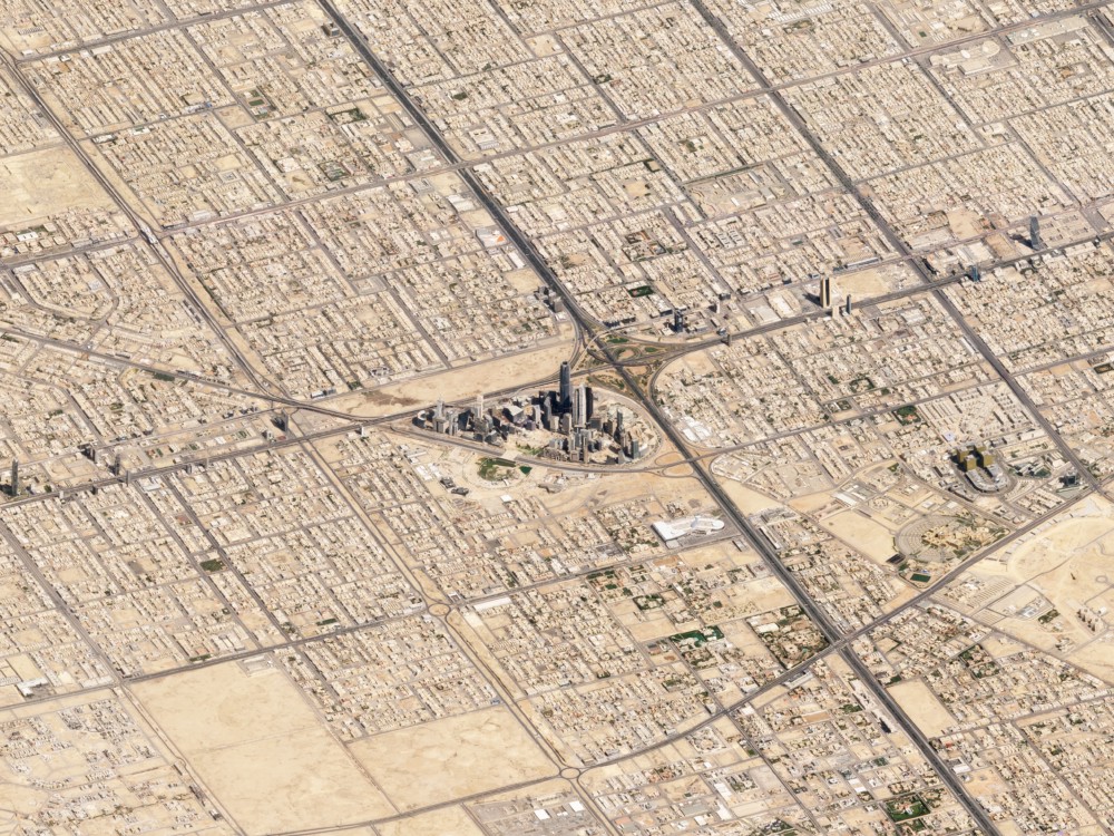
3) Riyadh, Saudi Arabia
Here, the SkySats capture Riyadh’s skyscrapers juxtaposed starkly with lower-density sprawlish development. Thanks to the bone-dry air of the place, the view from space is super-sharp!
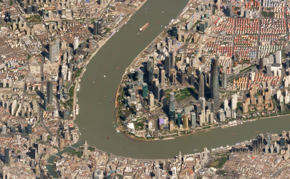
4) Shanghai, China
Located east of the Huangpu River, Shanghai’s Pudong district is a straggling yet sparsely populated area. The picture below shows what was once China’s tallest structure – Oriental Pearl Tower – dwarfed by the nearby Shanghai Tower.
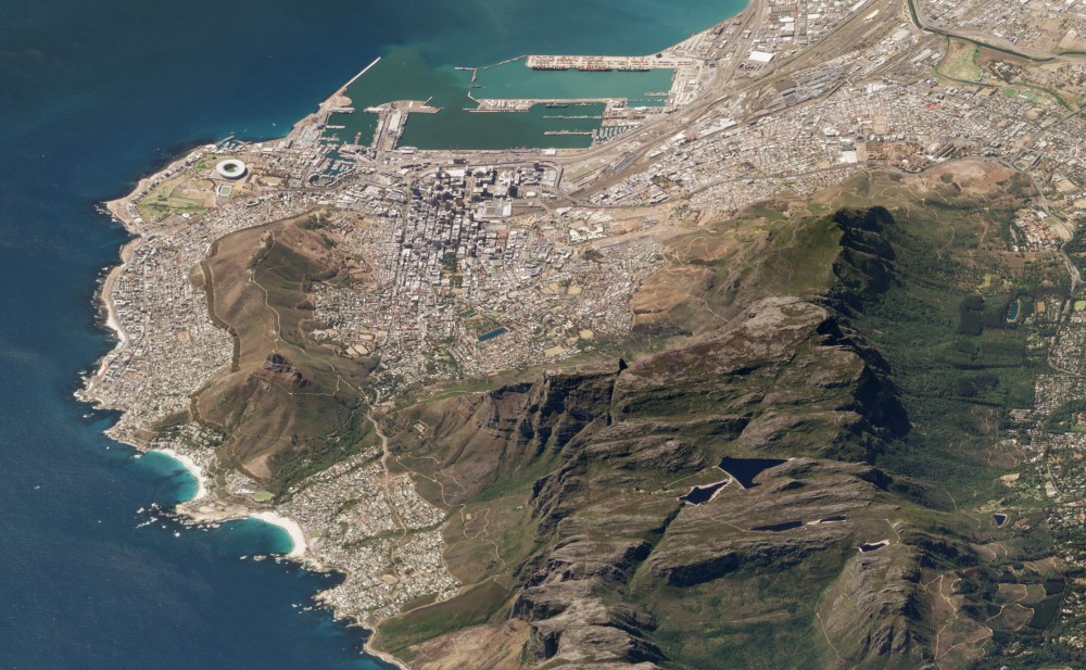
5) Table Mountain, Cape Town, South Africa
Cape Town locals are pretty fond of this iconic flat-topped mountain that looms over their city. A significant tourist attraction for travelers across the world, the mountain is home to a wide variety of endemic flora and fauna.
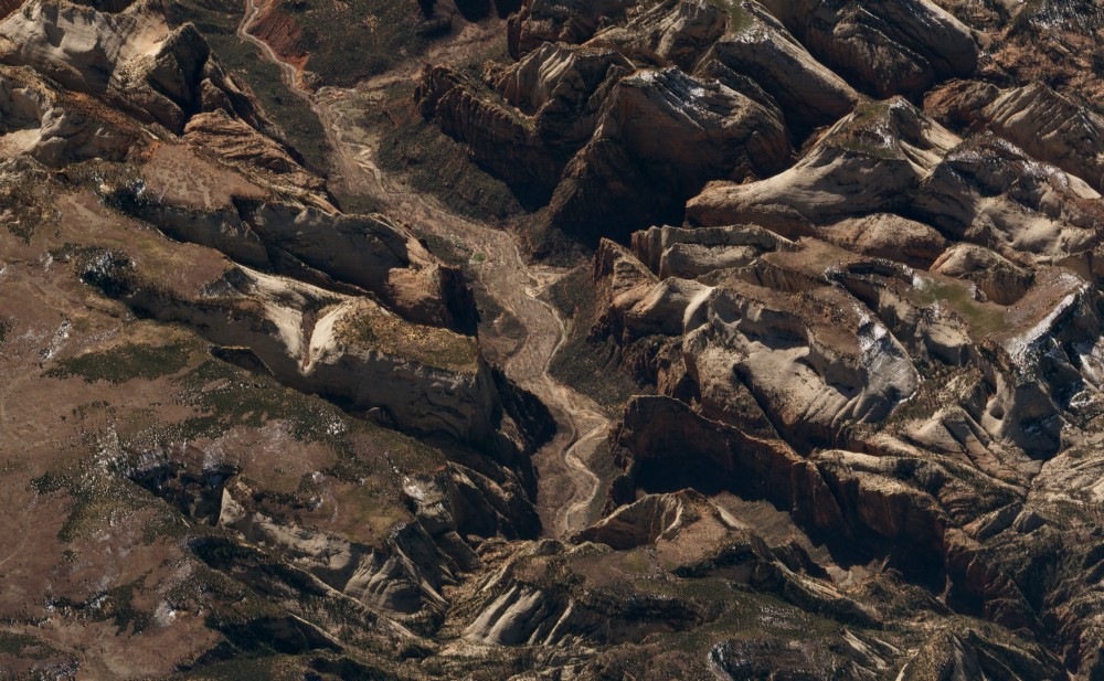
6) Zion National Park, United States
Nestled in southwest Utah, Zion National Park is loved by hikers and bikers for its massive sandstone cliffs of cream, pink, and red. Zion Canyon Scenic Drive cuts through its main section, leading to forest trails along the Virgin River.
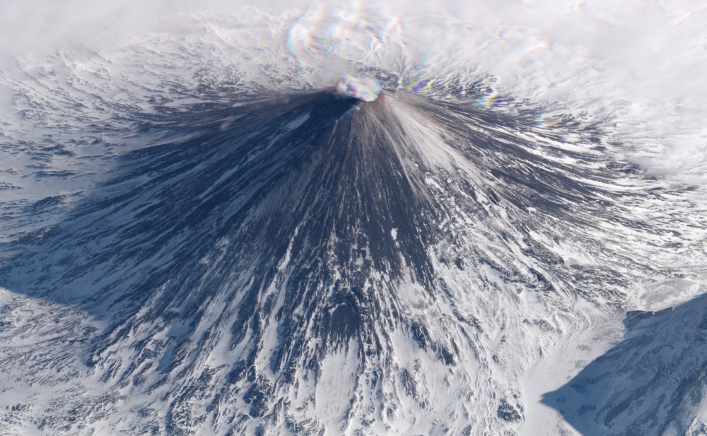
7) Klyuchevskaya Volcano, Russia
Being one of the highest active volcanoes in the world, the snowy slopes of Klyuchevskaya Volcano are almost always coated with dark ash. Its dramatic eruptions often force flights over the Kamchatka Peninsula to be re-routed.
To see more such magnificent off-angle satellite images by Planet, you can visit their blog.