How can we achieve a sustainable, safer and fairer society for all? With trusted geospatial data, says EuroGeographics

It was recently announced that data from official national sources is one of Europe’s most valuable resources in achieving a sustainable, safer and fairer society. The showcase by members of EuroGeographics, the not-for-profit membership association for Europe’s National Mapping, Cadastral and Land Registry Authorities, highlighted their role in providing fundamental information to implement the United Nations’ Sustainable Development Goals (SDGs).
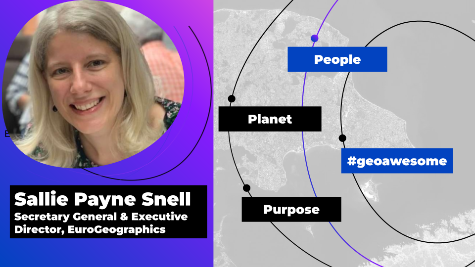
We sat down with EuroGeographics’ new Secretary General and Executive Director, Sallie Payne Snell, to learn more.
Firstly, congratulations! As an international not-for-profit organization, we’d love to learn more about your work representing providers of geospatial data. Could you tell us about what you’ll be focusing on in your new role?
Thank you! I’d like to start by emphasising what a great privilege it is to represent official providers of the trusted geospatial information that is fundamental to the everyday lives of people across Europe.
I am committed to championing its members’ data and expertise. Having previously led the Association’s operations, I’ve gained an in-depth understanding of the technological, legislative and operational challenges and opportunities facing National Mapping, Cadastral and Land Information Authorities and I will be using this to deliver membership benefits that support them in their national, European and global activities.
I’ll be focusing on enabling access to their high-value data and expertise through its integration into the infrastructures we rely upon as a modern society. This includes establishing partnerships with those who share our goal of using geospatial data for the public good; these are vital for meeting user requirements and finding solutions to common challenges.
We’re all about location here at Geoawesomeness. That’s why we were so excited to hear that EuroGeographics recently announced the pivotal role that location data plays in bettering the world. The showcase featured examples from Belgium, France, Germany and The Netherlands to demonstrate how location connects people with place for sustainable development, tackling climate change, creating digital twins, and developing intelligent transport systems. Could you share more about this dynamic between people and place?
Location is a powerful tool – it tells us where things happen but also provides the link between information and action. More than ever before, the world needs accurate data that it can trust is up to date, definitive and detailed – and it needs to know where to find it.
During our recent event at the European Parliament for MEPs and decision-makers, our members demonstrated how they provide context and clarity to information about people and places, so that we can gain insight and answers to some of the key issues facing society.
From integrating maps and data to provide insights for tackling climate change, providing information to support energy transition, and enabling multimodal transport strategies and digital transformation, we have a wide range of case studies on our website showing how members data and expertise play a key role in realising a sustainable, safer and fairer society.
The Sustainable Development Goals are crucial as a framework for the world to work towards. What role do you think geospatial data plays in us meeting them? And why is this new announcement about geospatial data so important to highlight?
Geospatial data enables the connection between people, their location and place, and in doing so allows us to measure where progress is, or is not, being made.
The United Nations recognises that a strong global geospatial infrastructure is an essential enabler for achieving its 2030 Agenda, but it’s not just the Sustainable Development Goals that depends on this information; sustainable development is also a priority objective for EU policy.
Data from official national sources is therefore one of Europe’s most valuable resources in gaining momentum towards a sustainable, safer and fairer society.
We work closely with colleagues in the European Parliament, Commission and its agencies, enabling them to access our members’ high-value data and expertise to realise a wide range of policies, including the EU’s Digital Decade and Green Deal. And as a friend of the EU Mission Adaptation to Climate Change, we fully endorse its charter and are committed to using our expertise and extensive network to strive towards climate resilience by 2030.
As the use of official geospatial data for the global indicators of the SDGs increases, what challenges do you foresee that may need to be overcome (e.g data access, processing capabilities, availability, cost)? How can the geospatial community contribute to solving these and what difference can we make together?
World leaders at the UN Sustainable Development Goals Summit, held recently in New York, expressed their alarm that their achievement is in peril.
We are now only seven short years away from 2030, and we are going through a time of crises and challenges – a global pandemic, conflict, and climate, food, fuel and global trade supply chain disruptions. Together these have contributed to a setback in delivering the Sustainable Development Goals – we know this because we have been measuring and monitoring our progress.
We obviously need to not only get back on track in leaving no-one behind, but also to get ahead of these crises. So, we need to understand where we are against the Sustainable Development Goals to target action. This is where geospatial data plays a key role.
The Sustainable Development Goals Report 2023 Special Edition highlights data challenges, calls for more inclusive data for development, and states the need to strengthen coordination within national data ecosystems.
At the United Nations Committee of Experts on Global Geospatial Information Management’s thirteenth session, we offered our support in enabling access to members’ high-value European geospatial data, sharing expertise and best practice, and demonstrating the use and value of location to provide a stronger and more inclusive development framework beyond 2030.
The UN-endorsed Integrated Geospatial Information Framework – or IGIF, which is being implemented by many of our members, helps to address these issues. The IGIF provides decision-makers with compelling evidence for strengthening geospatial capabilities in the context of meeting national priorities and global challenges. It enables the progress, measurement and monitoring of the Sustainable Development Goals by strengthening the management of national geospatial information to provide connections, context and clarity.
To fully realise the benefits for current and future generations, we encourage even greater use of official geospatial data for the global indicators of the Sustainable Development Goals. And, we strongly believe that the integration of geospatial data in the next development framework will not only make it stronger and more inclusive, but will also help realise the aspirations held by people around the world for a better future.
Why do you think it’s especially important that geospatial information comes from trusted sources in the modern age of misinformation? How does this impact everyday lives?
In uncertain times, authoritative map, cadastral and land registration information provides certainty to those responsible for making critical decisions. Trusted, transparent and interoperable public sector information based on fundamental rights and common values are key building blocks for a wide range of policies, including the EU’s Digital Decade and Green Deal, and the United Nations 2030 Agenda.
High quality and reliability is the calling card of EuroGeographics members, who provide much more than traditional maps. As the national authorities for official geospatial information in Europe, they use cutting edge technologies to collect, maintain and deliver high-value digital data and services to underpin the infrastructures we rely on as a modern society.
When we’re looking for somewhere, their maps pinpoint where to find it; when we’re buying property, our members provide secure registration, so ownership is certain; and when we need help, their data enables the emergency services to reach us quickly, saving time, and ultimately lives.
Whether it’s geospatial or land information, data and services provided by members of EuroGeographics are a fundamental part of our everyday lives: from apps, to ordering food deliveries; from online gaming to ensuring we pay the correct amount of tax: in fact, most of us use their information no less than 40 times a day, often without even realising.

Lastly, we know EuroGeographics is leading the Open Maps for Europe 2 (OME2) project. What’s involved in the project and how will it help with ensuring large-scale open data meets technical specifications for the UN Global Geospatial Information Management (UN-GGIM).
EuroGeographics and its members are already delivering high-value pan-European data through the Open Maps for Europe interface. We are building on this success through the OME2 project, which is co-funded by the European Union and responds to user needs for large-scale open data.
The project also supports the ambitions of the IGIF by aligning the technical specifications for large-scale open data with the core recommendations for content proposed by UN-GGIM: Europe.
OME2 will develop a new production process and technical specification for free-to-use, edge-matched data under a single open licence. Authoritative 1:10 000 scale data for 10 countries will be delivered via the user interface built by the award-winning Open Maps For Europe Project.
The prototype will provide three datasets, identified as key themes by users and defined as high-value in European Commission’s implementing rules for the Open Data and reuse of Public Sector Information Directive – administrative boundaries, transport and hydrography. OME2 will also enhance the five existing Open Maps For Europe datasets, including the pilot Open Cadastral Map.
Data is at the very start of the value chain, and the European Commission recognises geospatial as high-value data (HVD) offering a wealth of opportunities for reuse due to its compatibility with other datasets. By addressing the challenge of finding, accessing and licensing authoritative pan-European harmonised edge-matched, large-scale data, OME2 benefits both users and national providers of geospatial information.
For users, it saves time by providing machine-readable data as APIs from one central portal under one easy-to-understand open data licence. As a result, they will no longer need to visit individual Member State geoportals to access specific datasets, spend significant resources connecting them, or agree to multiple licences.”
For our members, who are recognised as important enablers of cross-border data applications and services, the prototype shows how public sector demand for geospatial information in all common data spaces of the European Strategy for Data can be met.
Furthermore, by allowing data to be easily uploaded, converted to the specification for each HVD theme, harmonised and edge-matched, OME2 will enable members to re-use techniques nationally and share good practices, advancing the data sharing tools needed to deliver free-flowing, interoperable data for the single market.
The OME2 project corresponds with Member States’ obligations to implement high-value data and will be completed at the end of 2025. It is being delivered by a consortium comprising: EuroGeographics, the not-for-profit membership association for Europe’s National Mapping, Cadastral and Land Registration Authorities; National Geographic Institute, Belgium; National Institute of Geographic and Forest Information, France; Hellenic Cadastre; General Directorate for the Cadastre, Spain; and Cadastre, Land Registry and Mapping Agency, The Netherlands.
More information is available at https://eurogeographics.org/
Did you like this article? Sign up to our newsletter!

#Business

Next article

Buying satellite data has never been as easy as it is today. Only a few years ago, attempting to source data was hugely challenging for anyone other than government clients (as this geoawesomeness blog post illustrates), but the process has undergone dramatic improvements since then.
Multiple marketplaces have empowered users to buy archived data or task satellites to capture new imagery—and to do so quickly and conveniently. There are options to suit all budgets, with open-source data of a low resolution accessible for free from the Landsat (>30m resolution) and Sentinel constellations (>10m), and high-resolution data available commercially from vendors such as Airbus, Planet and others.
However, despite the current availability of satellite data, it can be hard to fully understand how satellite data is priced and what to expect when we’re trying to buy it. Key providers have come up with various pricing models , including credits, subscriptions, and fixed prices, but obtaining a complete and clear picture can be challenging.
The main models available
When it comes to sourcing commercial satellite imagery, many satellite data pricing models are available, depending on the buyer’s needs. They can be broken down into four different categories:
1. Pay-as-you-go model
The most popular pricing model is the pay-as-you-go model. This approach allows customers to purchase satellite imagery data as and when they need it, without needing to commit to a long-term contract. The cheapest pay-as-you-go way of accessing data is to purchase archive data for a selected area of interest. This can be as small as 100m². At the same time,the pay-as-you-go model can also be used to task satellites to capture large amounts of data on specific future dates—the minimum order area is typically 50 or 100 km².
The pay-as-you-go model suits the majority of users and can be especially cost-effective for analysts working on smaller geospatial projects, those who only require data for a small area of interest, or customers with a limited budget.
Pay-as-you-go data is easy to access on satellite providers’ websites; however, for a lot of users, the easiest way to purchase data on a pay-as-you-go basis is through marketplaces, where it’s possible to access data from multiple providers in a clear and convenient way.
2. Subscription model
Using a subscription is another popular model for acquiring satellite imagery. This approach allows customers to access a wide range of data for a fixed recurring fee— ensuring predictable costs that enable clients to budget and plan more effectively. Subscription models are a particularly attractive option for those looking to access petabytes of archive data captured by top providers over several years.
Typically, subscription plans will also include some basic analytics features—such as vegetation indices or change detection—which adds significant value to the data provided. A few notable providers offering data through subscription models include:
- Planet Monitoring: Access 3m resolution Planet Scope data, refreshed globally every few days or weeks. If an area of interest is identified, users can access higher resolution SkySat data at an additional cost.
- Airbus Living Library: Purchase premium satellite data at multiple resolutions from Pléiades, Pléiades Neo and SPOT, plus access to a comprehensive historical archive.
- Maxar SecureWatch: On-demand access to frequently updated, high-resolution satellite imagery, plus analytics and other tools.
Subscription costs for these services can start from under $30k annually, making it an affordable and convenient option for users requiring consistent access to satellite data.
3. Basemap
A satellite basemap is actually the simplest and least expensive option of all, but will likely be insufficient for all but the most basic of uses. This model is typically used for web applications that display satellite data as a background option for any maps, but where the date of capture is of relatively low importance.
Using this method, a user has no control over the data’s age, but can source an adequate ‘mosaic’ of imagery for the entire world with a mix of 30–70 cm resolution data between 1–5 years old. We’d recommend a helpful trick d to verify the age of the data by comparing it with archive data available on Google Earth.
Popular sources for this type of data include Bing Maps, where an annual license starts at around €5000 (rising depending on the number of expected users). Other options, which provide newer data at a higher resolution, include Airbus Basemap and Maxar Vivid—which is now able to boast global coverage at 30cm.
4. Government and enterprise contracts
Lastly, at the other end of the spectrum, it’s worth mentioning the multimillion-dollar contracts that satellite providers secure with government institutions or very large enterprises. These are tailored to the specific needs of organizations and are likely to include advanced features and data access. Last year saw the largest satellite imagery contract in history being awarded to Maxar, with the National Reconnaissance Office (part of the US Defense Department) committing a massive $3.2 billion to the firm over a 10 year period.
Price drivers
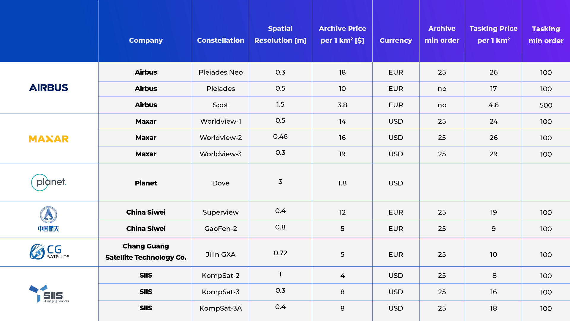
It is important to understand the factors that influence satellite data costs, especially when it comes to the most popular pricing model – pay-as-you-go. When analyzing typical pricing models offered (not including those multimillion-dollar contracts!), it becomes apparent that regardless of the packaging, price per 1km² remains the common denominator and baseline.
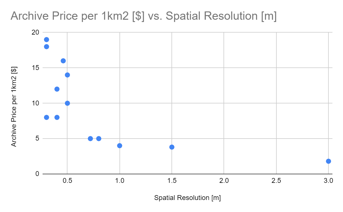
The primary differentiator is whether users are purchasing archived data or tasking satellites to capture on-demand data for a specific area of interest. In both cases, the price per km² depends mainly on the spatial resolution of the data, with higher resolution data costing more.
However, when budgeting for satellite tasking, the minimum order area becomes another crucial parameter, as tasking generally comes with a much larger minimum order size. For example, Airbus offers a minimum order of 100km² for the first purchase and 50km² for subsequent orders of the same area of interest.
Marketplaces provide a convenient way to buy data under the pay-as-you-go model. These platforms provide customers with a user-friendly interface and data filtering methods, offering access to satellite data from 20+ vendors, so analysts can make better-informed decisions when selecting and purchasing data for their projects.
The bottom line
The first question when it comes to satellite data is often simply “How much does it cost?”, but there’s not one single answer—in fact, there are options to suit almost every budget.
The price varies depending on factors including resolution, timeliness, area covered, and the data provider chosen: archive data from Airbus starts at just €3.80 for 1km2 of 50 cm resolution data, with no minimum order, but if you want 30cm resolution it’s €18 per km2, with a minimum order of 25km2. You can task a Kompsat satellite to capture 100km2 of 1m resolution data for just $800; while tasking Maxar’s Worldview-3 constellation to capture the same area (at 30cm resolution) will cost $2900.
Source: Infogeoafrica, 2020
Whatever the budget for a geospatial project,the main priorities for most of us will be convenience and transparency. Marketplaces are often the best way to secure both, providing a user-friendly platform where customers can find the option that suits their requirements.
Although the choice can perhaps be a little overwhelming, we can celebrate the fact that buying satellite data is no longer an insurmountable challenge. Just a year or two ago, it seemed that providers had no interest in selling their data to private customers.
They may not exactly be falling over each other to do so now, and there are still a couple of hoops to jump through, but there has been a giant leap forward—which can only be a good thing for the democratization of the Earth Observation industry.
Did you enjoy reading this article about satellite data pricing? Sign up to our newsletter for more: