How can remote sensing data be used to track plastic in the ocean?

Editor’s note: This article was written as part of EO Hub – a journalistic collaboration between UP42 and Geoawesomeness. Created for policymakers, decision-makers, geospatial experts and enthusiasts alike, EO Hub is a key resource for anyone trying to understand how Earth observation is transforming our world. Read more about EO Hub here.
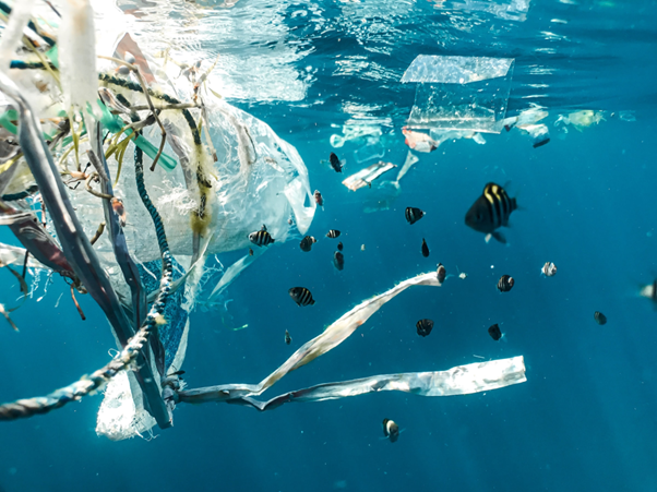
Around 10 million tonnes of plastic gets dumped into the oceans every year. The problem has gotten so bad that dumped plastics can be found in all parts of the ocean, from the equator to the poles and even frozen into polar ice. Vast ‘gyres’ of plastics exist in the Indian, Atlantic, and Pacific oceans. Two such gyres are so enormous that they have gained the name of the Great Pacific Garbage Patch. Smaller seas such as the Mediterranean and the North Seas are also developing their own garbage patches.
These garbage patches are not solid. They are simply enormous concentrations of plastic marine litter focused in one particular area.
Plastic cannot biodegrade. It breaks down into smaller and smaller pieces called microplastics. In the Great Pacific Garbage Patch — which stretches anywhere from a few centimetres to a few metres under the surface of the water — these microplastics make the water look like a thick soup.
Microplastics are ingested by marine life and eventually enter the global food chain. The long-term consequences of this to marine life and our own health are as yet unknown.
The problem with cleaning up this plastic is twofold:
- Until recently, nobody really knew just how much plastic was floating in the oceans.
- Lacking efficient reconnaissance techniques to determine the highest concentrations of plastics means that cleanup efforts are inefficient and overly costly for the amount of plastic recovered.
The Ocean Cleanup is a Netherlands-based non-profit organisation founded and led by Boyan Slat with the purpose of developing technology to clean up our oceans. What they have learned is that to clean the plastic, you need to learn to locate it effectively.
How The Ocean Cleanup moved to using Earth Observation data
Back in 2014, no one really knew how much plastic debris was floating around in the oceans. Numbers between tens of thousands and tens of millions of tonnes of plastic were floated. To understand the scale of the problem, The Ocean Cleanup needed to get an accurate figure of how much plastic there was to be cleaned up.
Todetermine the amount of plastic, The Ocean Cleanup launched something called the Mega Expedition. “We crossed the ocean with 30 boats at the same time, taking more measurements in three weeks than in the preceding 40 years combined,” said one of the non-profit’s representatives.
The team discovered that there was debris that was even larger than what they were able to properly sample. So they launched yet another unprecedented expedition, this time using a Vietnam War Era C-130 Hercules aircraft to spot large debris and determine how much of it was in the ocean.
The results from both expeditions were alarming. About 80 million kg of plastic spanned an area that was three times the size of continental France. Of all that garbage, 92% of the mass is still contained in larger objects (>5mm).
“In just two-and-a-half hours, our crew observed more than a thousand large objects of plastic floating underneath this aircraft,” said Boyan Slat.
By focusing on collections of large objects, the team can prevent the breakdown of these objects into microplastics that can enter the food system over the next few decades.
Plastic detection from space
But aerial mapping using aircraft was simply too costly to be done on a large scale. Satellite data seemed the logical option, but there were several challenges involved:
In 2017, the organisation teamed up with ESA, Airbus — the same company that provides VHR satellite data through the UP42 marketplace — and various other spatial organisations to investigate the potentials of making “remote sensing a reliable, scalable and efficient source of data for marine debris.” The project was called RESMALI — Remote Sensing of Marine Litter.
The intent was to create a SWIR (Short Wave Infrared) spectral signature library for oceanborne plastics. The challenge with such a library comes in the form of biofouling — the accumulation of bacteria and other marine organisms — as well as the plastic’s brightness. Both of these factors can affect the reliability of the spectral signature.
The other factor was the power of the satellite. To make such hyperspectral observation work, the satellite camera must have an extremely high ground sample distance (GSD). At the time, the best commercial satellites provided grayscale imagery in VHR at a GSD of 30 cm/pixel. The purpose of RESMALI was to determine what GSD was required to accurately detect plastics in the ocean.
It was discovered that, to detect objects of 1 m2 (these occurred roughly every 1 km2), they needed a hyperspectral camera with a GSD of 10 m/pixel. Satellites of this capability still are not commercially available.
But the project set in motion follow-up projects to find better ways to detect plastics in the ocean. For example, following up on the RESMALI project, ESA launched the SPOTS (Spectral Properties of submerged and biofouled marine plastic litter) project to further investigate the effects of biofouling and water depth on spectral reflectance.
Ghost nets
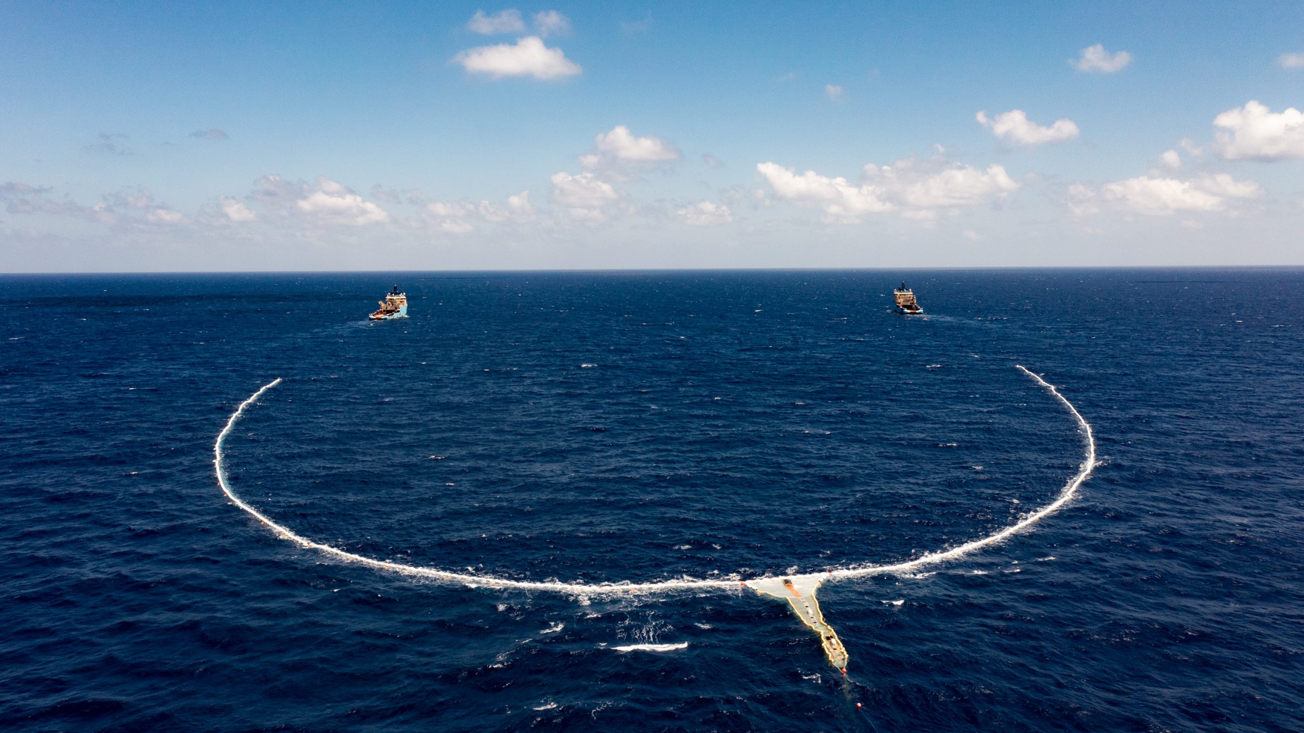
Waiting for the technology to be developed for a higher GSD was not an option. The team needed to find ways to determine the location of the highest concentration of plastic debris right now, using existing technology. The subject of ghost nets offered one possible solution.
Ghost nets are discarded fishing nets. Sea life can get trapped inside them, but they also indicate the presence of plastic around them.
The Ocean Cleanup developed several algorithms to detect ghost nets on the ocean’s surface and teamed up with Airbus to utilise satellite tasking to find these ghost nets.
To make this happen, The Ocean Cleanup required information on moving objects in less than 24 hours. Using the VHR Pléiades satellite developed by Airbus, The Ocean Cleanup Research Centre is able to order and receive tasking within 16 hours. Even during 56% cloud cover, the combination of rapid tasking and The Ocean Cleanup’s algorithms were still able to detect 10 ghost nets on 19 October 2018, the date they evaluated the system.
By determining the position of the ghost nets, The Cleanup Project is able to optimise its removal operations to focus on areas of highest concentration.
Conclusions
With at least 24.4 trillion pieces of microplastics estimated to be in the oceans, effectively cleaning up large oceanborne debris has never been more vital.
Using optical satellite data to map the position of plastic debris is challenging because only extremely large debris would be visible. Hyperspectral data, based on a dataset of spectral signatures, looks promising but it requires satellites with a high GSD that don’t currently exist for public usage.
The Ocean Cleanup is not giving up. And its efforts have spurred interest and innovation within the industry, giving rise to multiple projects across different technologies, each with the aim of finding ways to accurately map the position of these plastics so that cleanup efforts can be organised for maximum efficiency.
The Ocean Cleanup itself is testing another method of detecting marine debris — this time installing cameras with GNSS systems on vessels, and then using Deep Learning to detect floating objects in the ocean.
Breakthroughs in satellite technology and a better understanding of how to remotely sense plastic debris in the oceans are opening doors to more efficiently remove this plastic from our waters. And the quick availability of satellite data and computing algorithms via platforms such as UP42 makes it possible to conduct research more easily.

#Data source

Next article
Editor’s note: This article was written as part of EO Hub – a journalistic collaboration between UP42 and Geoawesomeness. Created for policymakers, decision-makers, geospatial experts and enthusiasts alike, EO Hub is a key resource for anyone trying to understand how Earth observation is transforming our world. Read more about EO Hub here.
The Pléiades Neo 30-cm resolution satellite constellation from Airbus offers unprecedented visual quality. Although some other constellations offer the same pixel size, the clarity of the Pléiades Neo images is mind-boggling. It feels more like aerial than satellite data.
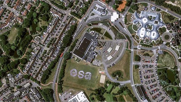
To show off the satellite’s incredible abilities, the European Space Agency (ESA) organised a group photo of 1,000 ESA personnel — from space. The personnel gathered on a rugby field, holding pieces of white paper on their heads, and stood in a formation that spelled the letters “esa.” The entire event had to be timed precisely as the satellite passed 700 km overhead.
The constellation is designed to offer a high revisit rate, allowing it to capture any location up to three times a day. Also, its spectral bands, including Red Edge and Deep Blue, enable new possibilities and applications.
Understandably, the geospatial industry is already eager to get their hands on Pléiades Neo data.
Buying satellite data has traditionally been extremely difficult
Even though buying satellite data is getting easier every month, it is still quite challenging.
The difficulties in easily obtaining satellite data are more apparent when dealing with very high-resolution imagery such as Pléiades Neo. There just wasn’t any marketplace around that provided a simple interface to browse available data. To preview and purchase Pléiades Neo data, it was necessary to go through customer support. This is a major drawback, especially for projects where you need data in a hurry.
This problem was solved by UP42, a Berlin-based startup that offers an online marketplace for customers to purchase satellite data and algorithms at scale. UP42’s latest platform release now adds the ability to preview and buy the high-res Pléiades Neo images immediately online without contacting sales. The search and purchasing process is also highly intuitive. Finding the right satellite scene is extremely easy. Here’s how it works:
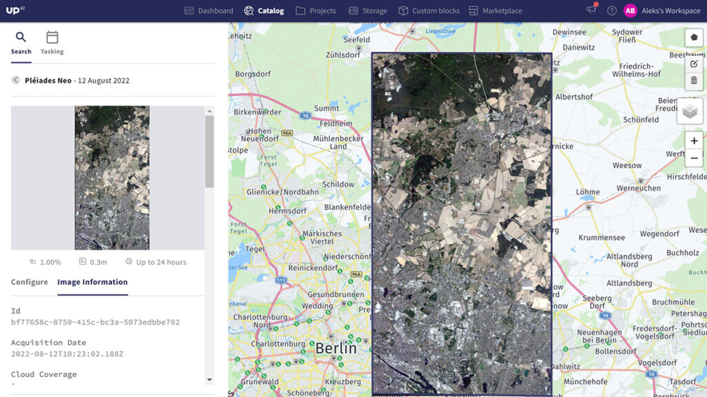
How does Pléiades Neo preview on UP42 platform work?
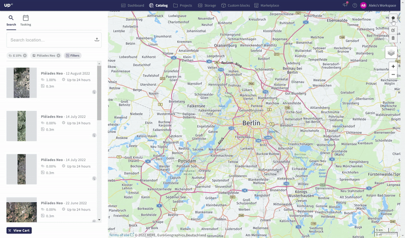
UP42 has provided an intuitive interface to zoom in on an area and preview all available archive Pléiades Neo satellite data(or other satellites they have imagery for, such as Pléiades, SPOT 6/7, and TripleSat).
Users can type in a physical address for the area they’re searching for, or draw a polygon on the map. They can also upload areas of interest in GeoJSON, KML, or Well-Known Text formats.
UP42 then provides search results for the data archive. The results are not in full resolution, but they are close enough to give the user a good idea of whether they want to purchase that data or not.
Once the user is satisfied that they’ve found the data they need, they can purchase the dataset with just a few clicks. The platform needs a bit of time to process the data (usually a few hours), and then the user can download the data.
Applications of Pléiades Neo
After buying Pléiades Neo, users can finally explore the wealth of possibilities and use cases it enables.
The data offers 30cm panchromatic resolution, with 1.2m resolution images in multispectral channels, making it highly useful for applications requiring close monitoring and counting of assets and infrastructure.
The positioning accuracy of the images is up to 3.5m, which makes it valuable for any use case that could benefit from change detection over time and overlaying other data layers, such as progress monitoring of a construction project.
Moreover, Pléiades Neo can be tasked, and its data downloaded and ready for analysis in below two hours, which makes it a game changer for emergency situations and disaster management.
The addition of the Red Edge spectral band enables more precise vegetation analysis and will support improved crop health analysis critical for precision agriculture.
On the other hand, the Deep Blue band is intended for hydrological and bathymetry applications. It allows deeper penetration into water bodies for a clearer understanding of waterways and improved safety in maritime navigation.
Buying high-res data must be easier
Very high-resolution satellite data is undoubtedly the future of Earth Observation. The more pixels and bands you have the more information can be extracted. In December 2021, Albedo, a start-up based in Austin, TX and Denver, CO, was granted an NOAA license to sell commercial optical imagery of their future constellation with a resolution of 10 cm, which suggests that even higher GSD data are just behind the corner.
The ease of buying very high-resolution satellite data must be improved for non-government users to unlock the full potential of such data for the benefit of society and the environment. At the same time, the higher the resolution, the more challenging data processing, storing, and analysing is. Users will not be able to effectively work with hundreds of gigabytes of data on their local PCs.
The role of platforms such as UP42 in buying and analysing very high-resolution satellite data will be critical. However, with the release of the new Pléiades Neo preview feature, we are getting there one step at a time.
Did you like the article? Subscribe to our monthly newsletter