

Synthetic Aperture Radar technology utilizes radar pulses to create detailed images or three-dimensional reconstructions of objects, such as landscapes or buildings. SAR is particularly valuable for EO as it can, unlike optical satellites, penetrate through clouds and operate in all weather conditions, both day and night. Various specialized techniques have been developed within the field of SAR technology, each suited to different applications. Here are a few types:
Most popular SAR techniques
1. InSAR (Interferometric SAR): This method involves using two or more SAR images of the same area taken from slightly different positions. By comparing these images, InSAR can measure changes in the Earth’s surface with high precision. This is useful for monitoring land subsidence, earthquakes or volcanoes.
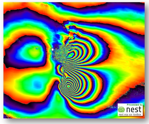
Interferogram – product of InSAR. Source: Copernicus.eu
2. DInSAR (Differential InSAR): An extension of InSAR, DInSAR uses differences between multiple interferograms taken at different times to measure surface changes over time more accurately. It is highly effective for tracking slow geological movements and the effects of human activities on the environment.
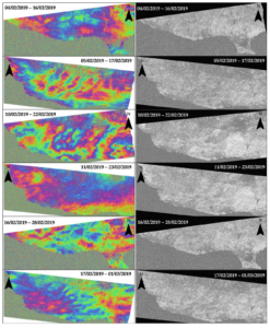
Differential InSAR. Source: MDPI
3. PSInSAR (Persistent Scatterer InSAR): This technique focuses on points in a radar image that remain coherent over a sequence of SAR images. It provides highly accurate measurements of very slow ground deformation over time. PSInSAR is particularly useful in urban areas where buildings or other structures provide consistent, reflective surfaces. This technique may be useful for displacement monitoring. Very insightful article is about Dutch Railway Monitoring using PSInSAR.
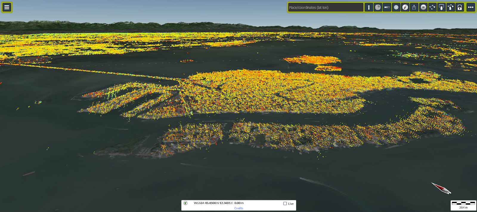
Venice and PS points. Source: EGMS
4. PolInSAR (Polarimetric InSAR): This method combines polarimetry and interferometry to analyze the scattering properties of targets in multiple polarizations. PolInSAR can provide additional information about the structure and properties of surfaces and objects, such as vegetation layers, and is useful in forestry and agriculture.
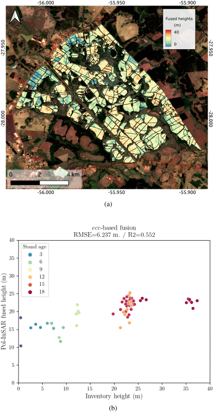
Determining the height of trees using PolInSAR. Source: https://ieeexplore.ieee.org/document/10423776
5. ScanSAR: This technique allows for wide-area imaging by using a modified scanning technique with the radar antenna. ScanSAR achieves broader coverage by reducing the radar resolution, making it effective for large-scale environmental monitoring, such as ice-sheet dynamics, large-scale deforestation, and flood extent mapping.
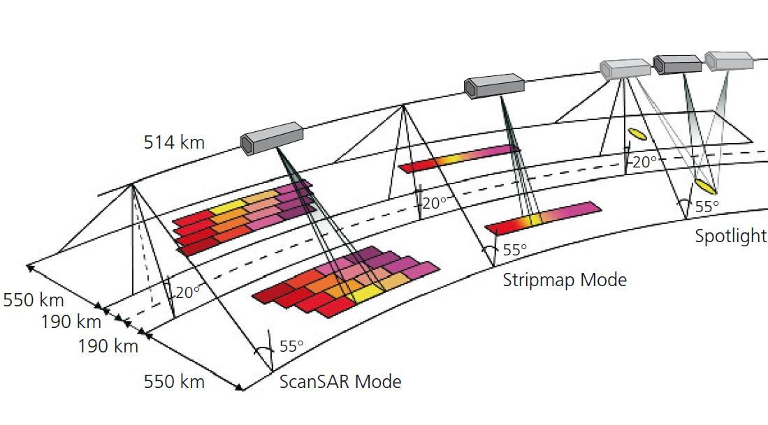
Satellite measurement modesL ScanSAR, Stripmap, Spotlight. Source: ResearchGate
6. TOPSAR (Terrain Observation by Progressive Scans SAR): An advanced form of ScanSAR, TOPSAR utilizes a special scanning technique that progressively steers the antenna along the flight direction. This method reduces scalloping effects and improves image quality over large areas, which is beneficial for ocean monitoring and environmental studies.

TOPS image result. Source: https://www.ncbi.nlm.nih.gov/pmc/articles/PMC6695588/
7. GMTI (Ground Moving Target Indication) – SAR-GMTI: GMTI technology is designed to detect and track moving objects on the ground, such as vehicles. By comparing multiple SAR images taken over the same area at different times, GMTI can isolate and identify movements within the scene, useful for surveillance and reconnaissance missions.
Tracking velocity of moving objects using SAR-GMTI. Source: ResearchGate
8. Compact Polarimetry SAR: This is a simplified form of full polarimetric SAR that transmits and receives radar signals in more than one polarization, but not all possible polarizations. It offers some of the benefits of full polarimetry but with reduced data volume and complexity. This technique can be used in applications like agriculture, wetlands monitoring, and soil moisture estimation.

SAR Compact Polarimetry for Soil Moisture Retrieval. Source: MDPI
9. HSI-SAR (Hyperspectral Imaging SAR): This approach combines hyperspectral imaging with SAR capabilities. By capturing a wide spectrum of frequencies along with radar data, HSI-SAR can provide detailed information about the material properties and changes in a landscape, useful in mineral exploration and environmental monitoring.
Multispecral imagery & radar images. Source: ResearchGate
10. Bistatic and Multistatic SAR: Unlike traditional monostatic SAR where the transmitter and receiver are colocated (often on the same platform), bistatic SAR involves separate locations for the transmitter and receiver. Multistatic SAR includes multiple receivers and possibly multiple transmitters. These configurations can enhance spatial resolution and reduce temporal decorrelation, offering advantages in urban mapping and complex environment monitoring.

The idea of Bi- and Multistatic SAR. Souce: MDPI
Conclusions
These techniques extend the capabilities of SAR technology, enabling diverse applications across various fields such as geology, hydrology and agriculture.
The potential for growth in SAR technology is significant, particularly as the satellite industry continues to evolve. Advances in satellite tech, such as the development of smaller, more cost-effective satellites and the increased launch opportunities provided by private space ventures, are expanding access to SAR data. This progress allows for more frequent updates and greater coverage, enhancing the ability to monitor and respond to global changes.
Moreover, innovations in data processing, ML, and AI are making it possible to extract more detailed and complex information from SAR data. As these technologies continue to mature, the number of specialized SAR techniques and their applications are likely to grow, leading to more precise, efficient, and versatile remote sensing capabilities. This evolution will put SAR technology as an irreplaceable tool in our increasingly approach to managing resources and addressing challenges.
Did you like this post about SAR techniques? Read more and subscribe to our monthly newsletter!

#Satellites

Next article
Geo Addressing Decoded Part 2: Beyond Coordinates – Exploring the Depth and Impact of Geo Addressing
Addressing systems do more than just guide mail delivery or help us find our way; they are foundational to how we understand and interact with the world around us. From the differing needs of a company providing delivery services or waste collection to those of an insurance or telecommunications firm, modern addressing systems must account for a vast array of considerations, from the location of the building to its physical characteristics and the ways in which electronic signals propagate through its walls.
In the first part of our ‘Geo Addressing Decoded’ series, we explored the significant challenges faced by traditional addressing methods, as organizations wrestle with globally diverse addressing systems, regularly changing address data, and incomplete and inconsistent datasets. Inadequate addressing systems present critical challenges across numerous sectors: Delivery and logistics companies face repercussions from misdirected or lost parcels; the insurance industry runs the risk of inaccurate policy pricing; fraudulent transactions are carried out through the simple manipulation of address details. This all exposes the vulnerabilities in our current systems, emphasizing the urgent need for robust and secure solutions.
This second article aims to delve deeper into some of those solutions, exploring how technological innovations offer new ways to solve age-old problems, and looking at why Geo Addressing is emerging as a unique and robust solution.
Early Technological Innovations: Geocoding
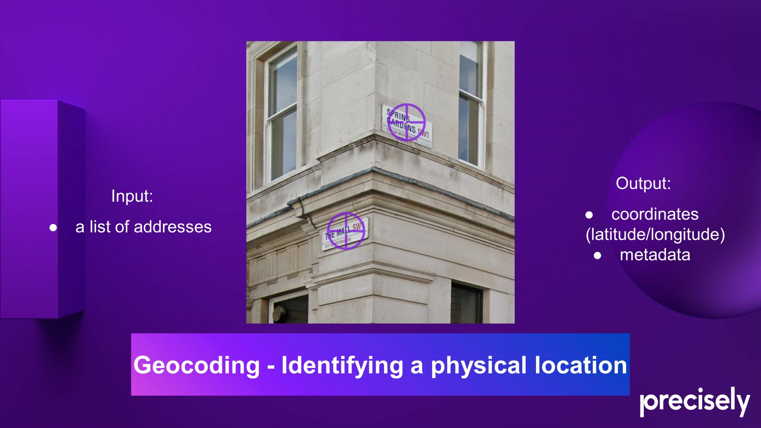
The ready availability of Global Positioning System (GPS) technology, combined with a host of new digital mapping and navigation tools, has transformed the way we think about addresses. Today, if we know someone’s address, we can view its location on a digital map; we can plug it into a GPS device or phone to be guided to it by private or public transport; we can even see what it looks like using Google Street View! All thanks to geocoding: translating known addresses into coordinates that can be used for mapping and analysis.
Consumer mapping platforms have made significant strides in making location data more accessible. Launched in 2005, Google Maps is widely recognized for its consumer-facing mapping and navigation services, but it also expanded the accessibility of geocoding by integrating geocoding capabilities into the Google Maps API. HERE is another digital mapping and location service company that provides detailed maps, navigation assistance, and location-based services. It has grown to become one of the largest location services in the world, with a primary focus on business solutions. Its Geocoding API enables businesses to integrate location information and address conversion, catering to a wide range of industries, including logistics and automotive. Its technology is used extensively in automotive navigation systems.
Reverse Geocoding
The process of reverse geocoding, where coordinates are converted to a more user-friendly ‘code,’ is becoming increasingly significant.
What 3 Words is a particularly notable innovation in this field, which divides the world into a grid of 3m x 3m squares, each assigned a unique three-word identifier. This location system provides a proxy for an address where addressing systems are inadequate or non-existent—such as in large, undifferentiated spaces or remote areas. It has been a game-changing technology for emergency services, enabling responders to locate individuals in need with speed and accuracy, when conventional addresses fail to provide sufficient detail.
Part of Google’s API, Plus Codes is another technology designed to provide an accurate way to identify any location on Earth, especially places that do not have a traditional street address. Plus Codes convert geographic coordinates into a short string of characters, creating a standardized code that represents a specific location. Like What3Words, the main advantage of Plus Codes is their ability to provide addresses in areas where the existing address system is insufficient, confusing or absent. They can be used for a wide range of purposes, including emergency services, navigation, and facilitating deliveries in areas that traditional addressing systems do not cover well.
The Limitations of Geocoding: The Complex Nature of Human Geography
Despite technological advances in location and mapping tools, both traditional addressing and modern geocoding solutions fall short when it comes to the particular intricacies of addressing. Geo Addressing is a field that combines human and physical geography, revealing the stories of our built environment and the societal decisions that shape it.
Tools like What3Words and Plus Codes, while innovative, deal with purely physical geography: points or squares based on latitude and longitude. Fundamentally, they are a stand-in for coordinates. However, an address encompasses far more than mere geographic coordinates. Addresses operate within multi-layered contexts, extending across multiple plots or even legal jurisdictions. An address might represent a PO box, lacking a tangible location per se. Addresses can also be three-dimensional, commonly ‘stacked’ atop one another in apartment complexes. Moreover, the specific geographic coordinates of an address may vary depending on the context—for instance, tax purposes might require the centroid of an address, whereas door-to-door delivery necessitates the address’s entry point.
Location services like HERE are primarily navigation engines. They are invaluable for guiding us through streets and highways, but prioritize street geometry over ‘secondary’ address details—in other words, sub-building or unit-level addresses—which are critical for accurate deliveries and provision of services. These location services simplify addresses to mere points, overlooking the layered realities of physical spaces.
The human complexity inherent in addresses exposes the limitations of a coordinate-based approach. It necessitates a shift towards a more targeted and nuanced approach that can accurately represent physical spaces in all their complexity.
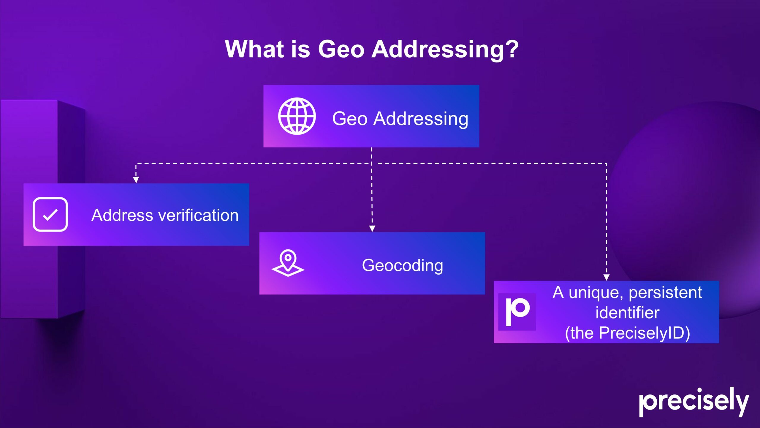
Geo Addressing and the PreciselyID: A New Era of Addressability
One of the most elegant and sophisticated addressing solutions is the ‘Geo Addressing’ service provided by Precisely. Beyond simple geocoding, Precisely’s unique identifier system simplifies how we manage addresses by replacing every multi-field address description with a unique identifier: the PreciselyID.
The PreciselyID system is applied to every ‘addressable location,’ meaning a physical address at the lowest granular level, whether a whole house or an apartment or unit within a larger building. Fundamentally, the objective is—to get as close to the ground truth of a location’s actual geographical footprint as possible and enable easy and fast enrichment for context. The PreciselyID is accepted as the de facto ID standard for hundreds of corporations across the globe.
Precisely’s Geo Addressing system has multiple benefits and applications across numerous sectors. The three key functions are: address autocompletion, address validation and verification, and geocoding plus PreciselyID. These processes combined provide the foundation of address data integrity: ensuring that the address information provided by a customer is accurate, complete, and contextual. After all Precisely is the leader of data integrity and addressing is one of the fields at which they excel.
Businesses can harness the wealth of information available through the PreciselyID to create data-driven strategies. Every end user of Geo Addressing and geocoded information will have a different use or application for the data, which we’ll discuss in detail later in this series.
Addressing is a field where geography, anthropology and technology all meet, as addresses reflect not just geographic realities but also the outcomes of political and social change. It’s a landscape that challenges conventional systems. The evolution of addressing systems—from traditional methods to advanced technological solutions like Precisely ID—demonstrates a compelling trajectory towards greater accuracy and utility. The implications of these advancements extend far beyond the immediate concerns of delivery logistics or emergency response; they touch on fundamental aspects of global connectivity and economic development.
In our next article, we will take a deeper dive into some specific details of the technology behind Geo Addressing solutions, as we consider a future where every location in our increasingly complex world is seamlessly integrated into a global addressing system.
About Precisely
Precisely is a global leader in data integrity, providing 12,000 customers in more than 100 countries, including 99 of the Fortune 100, with accuracy, consistency, and context in their data. Precisely’s data integration, data quality, data governance, location intelligence, and data enrichment products enable better business decisions and drive better results. Learn more at www.precisely.com

Did you like the article about Geo Addressing? Read more and subscribe to our monthly newsletter!