Geo Addressing Decoded Part 2: Beyond Coordinates – Exploring the Depth and Impact of Geo Addressing

Addressing systems do more than just guide mail delivery or help us find our way; they are foundational to how we understand and interact with the world around us. From the differing needs of a company providing delivery services or waste collection to those of an insurance or telecommunications firm, modern addressing systems must account for a vast array of considerations, from the location of the building to its physical characteristics and the ways in which electronic signals propagate through its walls.
In the first part of our ‘Geo Addressing Decoded’ series, we explored the significant challenges faced by traditional addressing methods, as organizations wrestle with globally diverse addressing systems, regularly changing address data, and incomplete and inconsistent datasets. Inadequate addressing systems present critical challenges across numerous sectors: Delivery and logistics companies face repercussions from misdirected or lost parcels; the insurance industry runs the risk of inaccurate policy pricing; fraudulent transactions are carried out through the simple manipulation of address details. This all exposes the vulnerabilities in our current systems, emphasizing the urgent need for robust and secure solutions.
This second article aims to delve deeper into some of those solutions, exploring how technological innovations offer new ways to solve age-old problems, and looking at why Geo Addressing is emerging as a unique and robust solution.
Early Technological Innovations: Geocoding
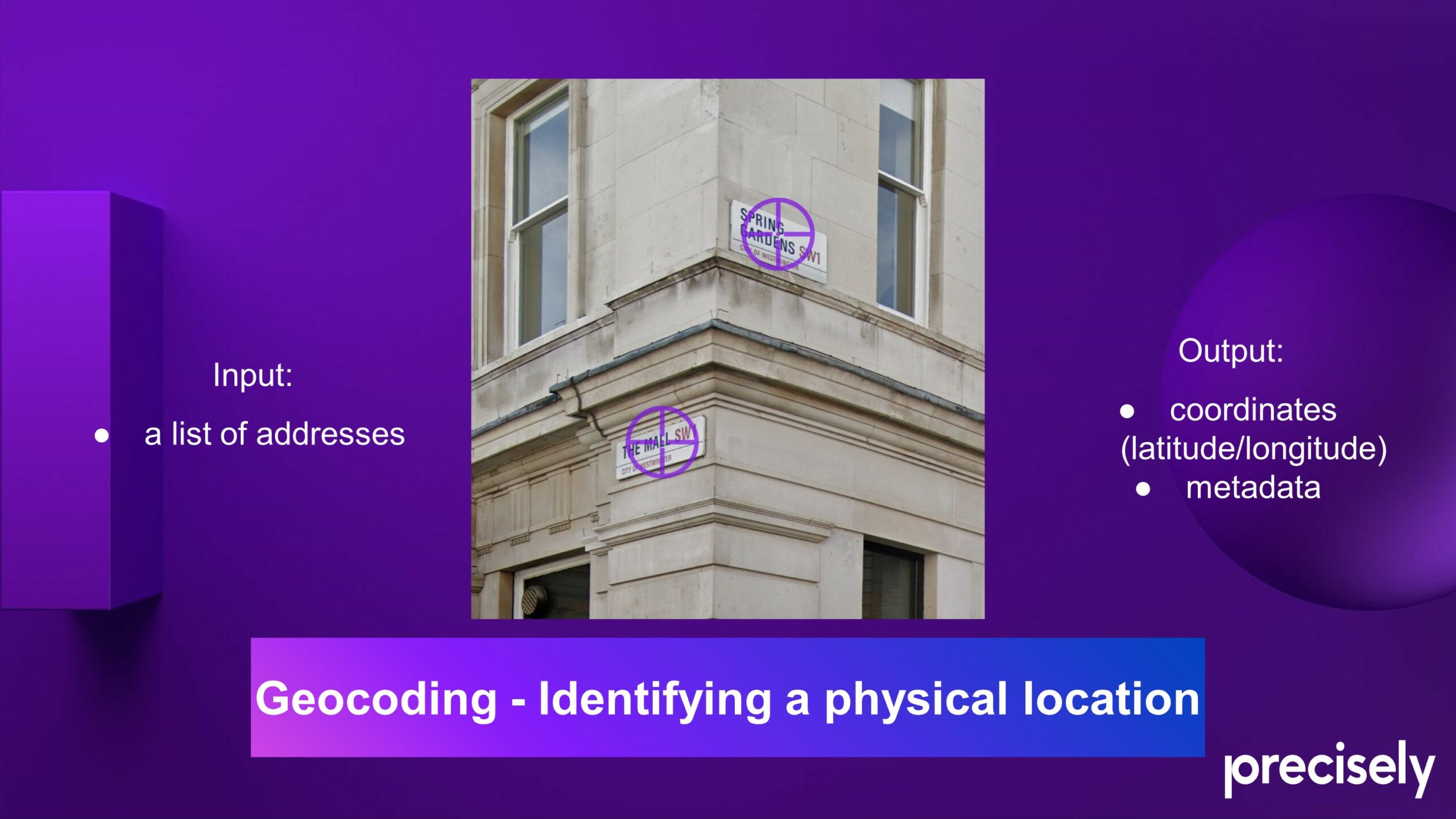
The ready availability of Global Positioning System (GPS) technology, combined with a host of new digital mapping and navigation tools, has transformed the way we think about addresses. Today, if we know someone’s address, we can view its location on a digital map; we can plug it into a GPS device or phone to be guided to it by private or public transport; we can even see what it looks like using Google Street View! All thanks to geocoding: translating known addresses into coordinates that can be used for mapping and analysis.
Consumer mapping platforms have made significant strides in making location data more accessible. Launched in 2005, Google Maps is widely recognized for its consumer-facing mapping and navigation services, but it also expanded the accessibility of geocoding by integrating geocoding capabilities into the Google Maps API. HERE is another digital mapping and location service company that provides detailed maps, navigation assistance, and location-based services. It has grown to become one of the largest location services in the world, with a primary focus on business solutions. Its Geocoding API enables businesses to integrate location information and address conversion, catering to a wide range of industries, including logistics and automotive. Its technology is used extensively in automotive navigation systems.
Reverse Geocoding
The process of reverse geocoding, where coordinates are converted to a more user-friendly ‘code,’ is becoming increasingly significant.
What 3 Words is a particularly notable innovation in this field, which divides the world into a grid of 3m x 3m squares, each assigned a unique three-word identifier. This location system provides a proxy for an address where addressing systems are inadequate or non-existent—such as in large, undifferentiated spaces or remote areas. It has been a game-changing technology for emergency services, enabling responders to locate individuals in need with speed and accuracy, when conventional addresses fail to provide sufficient detail.
Part of Google’s API, Plus Codes is another technology designed to provide an accurate way to identify any location on Earth, especially places that do not have a traditional street address. Plus Codes convert geographic coordinates into a short string of characters, creating a standardized code that represents a specific location. Like What3Words, the main advantage of Plus Codes is their ability to provide addresses in areas where the existing address system is insufficient, confusing or absent. They can be used for a wide range of purposes, including emergency services, navigation, and facilitating deliveries in areas that traditional addressing systems do not cover well.
The Limitations of Geocoding: The Complex Nature of Human Geography
Despite technological advances in location and mapping tools, both traditional addressing and modern geocoding solutions fall short when it comes to the particular intricacies of addressing. Geo Addressing is a field that combines human and physical geography, revealing the stories of our built environment and the societal decisions that shape it.
Tools like What3Words and Plus Codes, while innovative, deal with purely physical geography: points or squares based on latitude and longitude. Fundamentally, they are a stand-in for coordinates. However, an address encompasses far more than mere geographic coordinates. Addresses operate within multi-layered contexts, extending across multiple plots or even legal jurisdictions. An address might represent a PO box, lacking a tangible location per se. Addresses can also be three-dimensional, commonly ‘stacked’ atop one another in apartment complexes. Moreover, the specific geographic coordinates of an address may vary depending on the context—for instance, tax purposes might require the centroid of an address, whereas door-to-door delivery necessitates the address’s entry point.
Location services like HERE are primarily navigation engines. They are invaluable for guiding us through streets and highways, but prioritize street geometry over ‘secondary’ address details—in other words, sub-building or unit-level addresses—which are critical for accurate deliveries and provision of services. These location services simplify addresses to mere points, overlooking the layered realities of physical spaces.
The human complexity inherent in addresses exposes the limitations of a coordinate-based approach. It necessitates a shift towards a more targeted and nuanced approach that can accurately represent physical spaces in all their complexity.
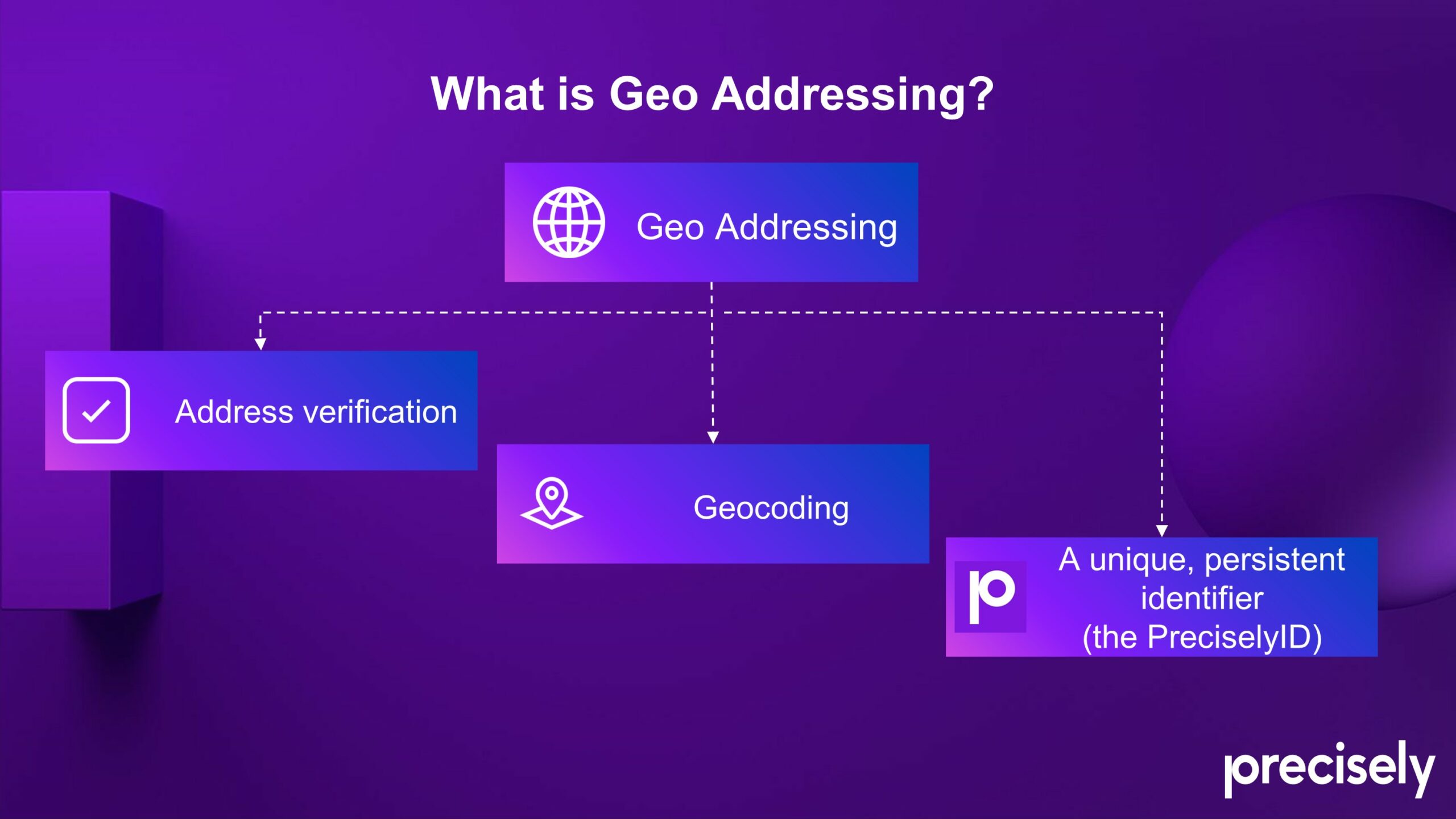
Geo Addressing and the PreciselyID: A New Era of Addressability
One of the most elegant and sophisticated addressing solutions is the ‘Geo Addressing’ service provided by Precisely. Beyond simple geocoding, Precisely’s unique identifier system simplifies how we manage addresses by replacing every multi-field address description with a unique identifier: the PreciselyID.
The PreciselyID system is applied to every ‘addressable location,’ meaning a physical address at the lowest granular level, whether a whole house or an apartment or unit within a larger building. Fundamentally, the objective is—to get as close to the ground truth of a location’s actual geographical footprint as possible and enable easy and fast enrichment for context. The PreciselyID is accepted as the de facto ID standard for hundreds of corporations across the globe.
Precisely’s Geo Addressing system has multiple benefits and applications across numerous sectors. The three key functions are: address autocompletion, address validation and verification, and geocoding plus PreciselyID. These processes combined provide the foundation of address data integrity: ensuring that the address information provided by a customer is accurate, complete, and contextual. After all Precisely is the leader of data integrity and addressing is one of the fields at which they excel.
Businesses can harness the wealth of information available through the PreciselyID to create data-driven strategies. Every end user of Geo Addressing and geocoded information will have a different use or application for the data, which we’ll discuss in detail later in this series.
Addressing is a field where geography, anthropology and technology all meet, as addresses reflect not just geographic realities but also the outcomes of political and social change. It’s a landscape that challenges conventional systems. The evolution of addressing systems—from traditional methods to advanced technological solutions like Precisely ID—demonstrates a compelling trajectory towards greater accuracy and utility. The implications of these advancements extend far beyond the immediate concerns of delivery logistics or emergency response; they touch on fundamental aspects of global connectivity and economic development.
In our next article, we will take a deeper dive into some specific details of the technology behind Geo Addressing solutions, as we consider a future where every location in our increasingly complex world is seamlessly integrated into a global addressing system.
About Precisely
Precisely is a global leader in data integrity, providing 12,000 customers in more than 100 countries, including 99 of the Fortune 100, with accuracy, consistency, and context in their data. Precisely’s data integration, data quality, data governance, location intelligence, and data enrichment products enable better business decisions and drive better results. Learn more at www.precisely.com

Did you like the article about Geo Addressing? Read more and subscribe to our monthly newsletter!

#Business


Next article
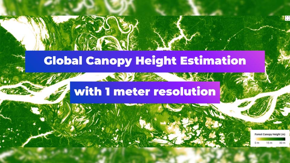

That’s just a geoawesome news! The quality of satellite-based products is improving year by year! Here’s a perfect example of mapping the elements of Earth’s environment globally. Meta Sustainability group and the World Resources Institute have recently released a Global Canopy Height map at 1m resolution.
What is Global Canopy Height Estimation?
Global Canopy Height Estimation refers to the process of determining the height of forest canopies around the world using various remote sensing techniques. This estimation is crucial for several ecological and environmental studies, including biodiversity assessment, biomass estimation, and climate change research.
Gathering of the data
To generate this global map there was a need to collect 18 million satellite images from 2009 to 2020, highlighting the data from 2018 to 2020. Over 1 trillion pixels resulted in an impressive 15+ TB of data! What about the accuracy? From information provided by the authors the mean absolute error is 2.8 meters. To generate the model AI tool such as DiNOv2 was used, which enables for accurate assessment of carbon stocks.

Canopy height in NYC, Google Earth Engine
Comparison with data from 2005 and 1km resolution, Belem, Brasil, South America, Source: Google Earth Engine
Spreading the news!
Thanks to the authors it’s possible to check out the possibilities of The Canopy Height map by yourself! Follow the link for online application. Case studies above were created using Google Earth Engine and uploading the following variables:
- Newest version: 1 meter resolution map:
var canopy_ht = ee.ImageCollection(“projects/meta-forest-monitoring-okw37/assets/CanopyHeight”)
- Older version: 1 kilometer resolution map:
var dataset = ee.Image(‘NASA/JPL/global_forest_canopy_height_2005’)
Know the difference: Global Canopy Height Estimation vs. nDSM
Mentioned Height map may sound familiar to nDSM – Normalized Digital Surface Model, but it’s limited only to the processed and modeled height of the canopy. nDSM presents the height of all surface structures above the ground, eg. buildings, infrastructure and vegetation. It’s generated by raster differencing DSM and DEM rasters. Example below is a visualization of DEM (Digital Elevation Model), DSM (Digital Surface Model), nDSM and satellite imagery for the west district of San Francisco. In nDSM visualization it’s notable that buildings are included next to tree cover in parks.
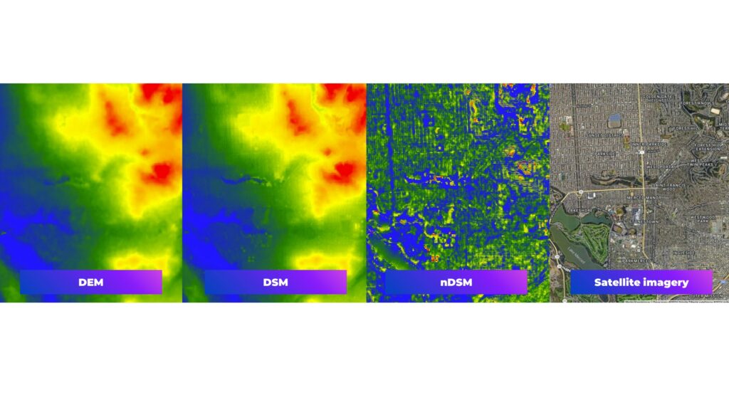
Know the difference. DEM, DESM and nDSM model
Conclusions
The recent release of a Global Canopy Height map at 1 meter marks a significant advancement in satellite-based monitoring. Utilizing the AI tool DiNOv2, this initiative analyzed satellite images, resulting in a highly detailed map that significantly improves the assessment of carbon stocks. This breakthrough demonstrates how AI tools are instrumental in enhancing the quality and precision of satellite-derived products, offering more reliable data and automation processing for ecological studies and environmental management.
Source: gee-community-catalog.org
Did you like the article? Read more and subscribe to our monthly newsletter!