
Imagine you are looking for a flat to rent around your office. Usually, you would google for a property site, enter your zip code, select a bunch of options about how big it has to be, how much the rent should be, the optimal distance from your office, etc. As a geogeek the most interesting aspect of all this is the distance i.e. the geofencing.
How exactly does the website return all properties that are within N kilometres from your office? What happens behind the scenes of a location based search? There are many options for programmers to implement a location-based search e.g. they can map the distance that it takes to walk/drive to the office or maybe the time it takes to get to your office with public transportation. But more often that not, what we get is a simple map with a 5KM radius mapped using an “as the crow flies” distance calculator.
“As the crow flies” approach has its benefits and makes it easier for websites to give users a rough idea of how far their points of interest are from a particular location. But as humans, we can’t drive in the same way as the crow flies (at least, until jet packs become a reality) – our roads and public transportation networks are more complicated than a simple radius search might lead us to believe. Travel time-based location search makes way more sense in such a scenario than a simple radius based approach.
Searching by time not distance
Calculating the time it takes from A to B, is rather easy – most mapping applications including Google Maps and Here have this feature, so a simple solution might be entering the address of the office and finding out how long it takes to one of your preferred rentals with your preferred mode of transport. Now, imagine doing this for ten properties? Still manageable. How about 50 properties? Surely, there has to be a better way to do this.
But why would you prefer searching by time rather than by distance in the first place? Aren’t they the same?
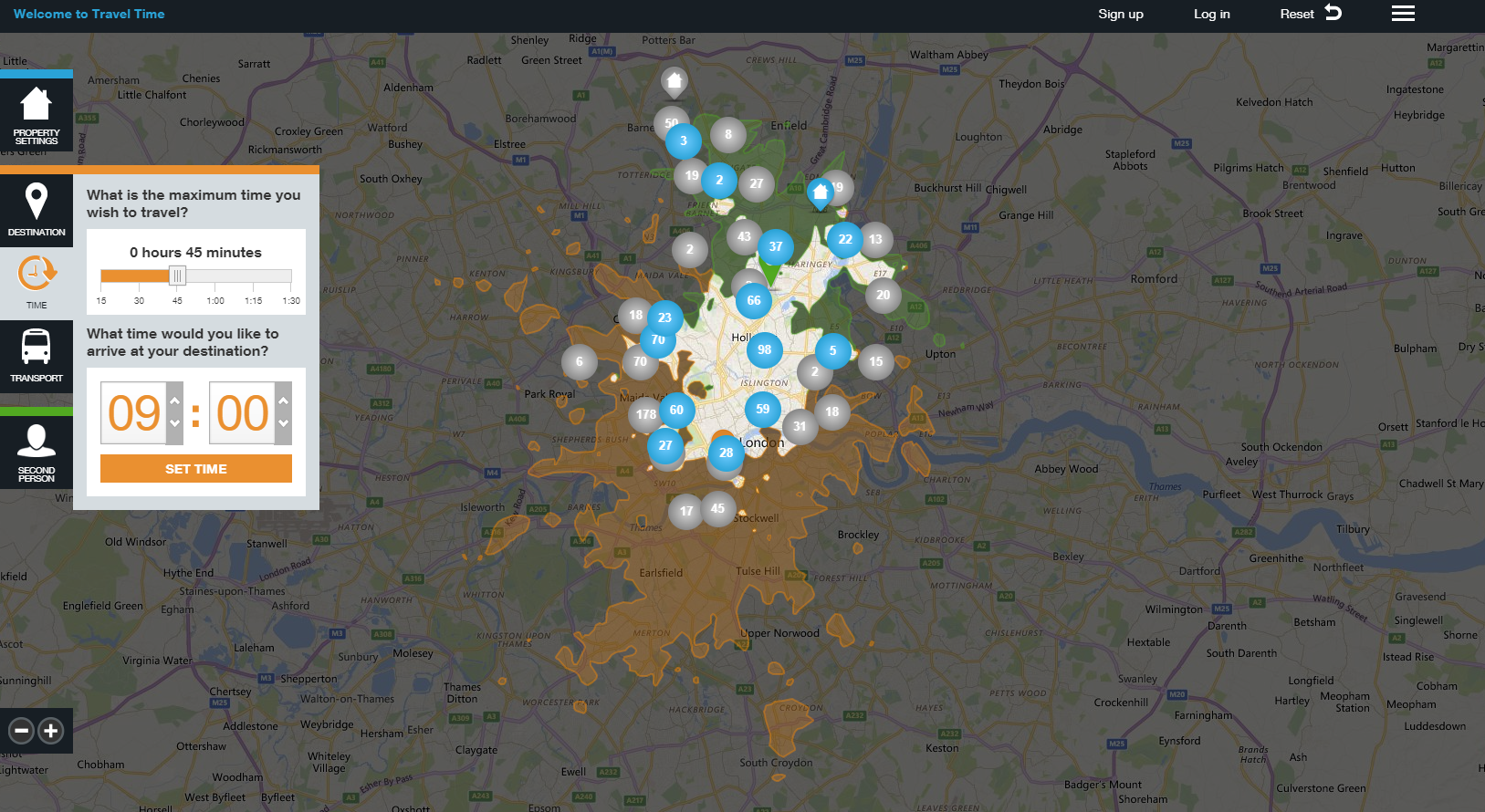
When comparing miles radius and TravelTime side by side, you see that many of the results returned using distance aren’t easy to reach. The grey markers on the map above highlight these unreachable points that are served with a distance search despite how long it takes to reach them. As we know some places are located along fast transport routes such as quick train lines or motorways. The points in orange pinpoint locations that seem far away but are easy to get to.
Unfortunately, even Google and Here can’t help us with such a search. This is where the London-based startup, iGeolise comes in.

Peter and Charles began iGeolise back in 2009 and is one of the winner’s of the UK leg of the European Satellite Navigation Competition. Interestingly, Charlie came up with the idea to search using time rather than distance whilst waiting in a traffic jam. Realizing that an API that uses “as the crow flies” distance calculation is always going to ignore local transport network, traffic congestion and the dynamics of the city, they decided to build the TravelTime Search API.
On a side note: iGeolise’s first office wasn’t a garage but Peter’s attic.
The API, which can display travel time areas on a map and sort location data by journey times, was inspired by isochrones used in GIS applications. The big difference is that response times for consumer facing apps need to be fast. iGeolise’s focus on returning data in the shortest time meant that the “Search API” now powers several property websites and job sites in the U.K. making it easier for users to measure everything in travel time instead of kilometres. TravelTime Search isn’t just a technological better solution; it has even lead to better conversion rates for iGeolise’s customers. It’s easy to imagine why – as a customer, I am going to spend more time on the site and finish my transaction if I don’t have to jump to a mapping application every single time to calculate the time it’s going to take me to get to work and stuff.
“Using TravelTime Search rather than distance provides a better user experience when finding locations online. This is because the user doesn’t need to calculate any routes when comparing which is the quickest point to reach. This is why a lot of our clients report increases in conversion rates. Our aim is to replace every distance-based search with a more relevant TravelTime Search.
The need for travel time data also expands beyond web search. We’ve helped businesses select a new office location by analysing staff commute times and looked at how new public transport networks will open opportunities for new store locations. We want to make location based decision making simpler and more accurate for everyone.” Charlie Davies, Co-founder, iGeolise
Difference for business using TravelTime
One of the first things that amazed me about iGeolise’s solution is how much better the travel time-based approach is. To see how transformative their solution is, you have to see it in action.
Looking to rent a property in London and want to be in the office each morning at 09.00 AM and don’t want to travel more than 15 mins with the public transportation to get there? There is an API for that 😉
Countrywide, one of UK’s largest estate agency and letting network uses the TravelTime API on their website and iGeolise reports that they were able to increase their conversions by 300%! I can imagine why more people preferred to use CountryWide over a website that did not have the ability to use time instead of distance.
If you are interested in creating your time travel map, check out the TravelTime Maps tool
The inner workings of the TravelTime platform
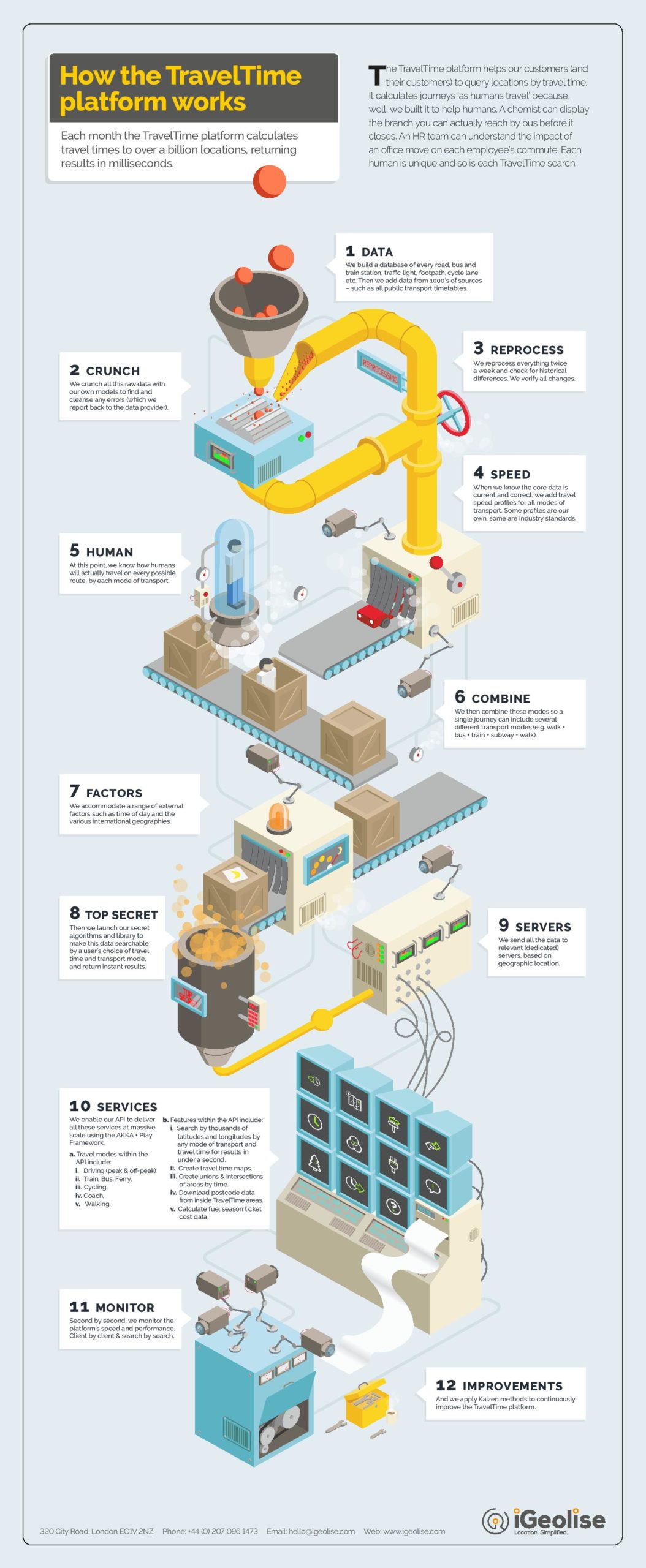
What goes on behind all this? How exactly does the travel time platform work? iGeolise sent us this helpful infographic (PDF) to get an overall idea of how what goes on in the background.
It’s amazing how a simple solution can transform the success of your business! Location-tech rocks 🙂


#Business


Next article

![]()
Apple is on a hiring spree. The company is looking for people who are skilled in the areas of mapping, geospatial information services, navigation and fleet management. Over 70 job listings pertaining to these specializations have been posted by Apple in the last month alone. And as CNBC notes, that’s a lot of jobs revolving around just one discipline. So, we can safely assume the technology giant has something big up its sleeve.
We are already aware that Apple has roped in some very, very smart people from Google’s satellite business, NASA and Tesla to its talent pool earlier this year. And that it’s painstakingly trying to improve its Maps product is also no secret. More recently, the Apple Mapping Van has been spotted driving around with four LiDAR sensors, capturing a 360-degree view of its surroundings. Who knows, we might even see 3D street view in Apple Maps in the times to come!
‘Big investments’ in augmented reality and AI
Meanwhile, on the Q3 earnings call earlier this month, Apple CEO Tim Cook was quite bullish about the company’s future in the field of augmented reality and autonomous systems – both of which require serious expertise in the field of location and positioning technologies.
Detailing that Apple’s ARKit, a new set of tools for developers to create augmented reality apps, has captured the imagination of the developer community, Cook said, “We believe AR has broad mainstream applicability across education, entertainment, interactive gaming, enterprise, and categories we probably haven’t even thought of. With hundreds of millions of people actively using iPhone and iPad today, iOS will become the world’s biggest augmented reality platform as soon as iOS 11 ships.”
When quizzed about Apple’s focus on self-driving technology, Cook didn’t comment on the company’s interest in autonomous vehicles, but did acknowledge that it is “very focused on autonomous systems from a core technology point of view.”
Cook admitted that a “large project” is going on in this field and that the company has been pouring in big investments to make it a success. “From our point of view, autonomy is the mother of all AI projects. And the autonomous systems can be used in a variety of ways and a vehicle is only one,” Cook said.