
First and foremost, wherever you are reading this from, I hope that you, your family and friends are doing well and keeping safe.
COVID-19 has disrupted even the best-made plans and our pet project – the Top 100 Geospatial companies of 2020 is no different. The nominations for the list were opened in January this year and we realize that it is time for an official update regarding the current status and when we hope to be able to close the nomination round, review the nominations and announce the list.
We understand that this is far from ‘business as usual’ and that companies have been struggling to cope with the impact of COVID-19 on their daily work and plans for the year. In light of these developments, we’ve decided to extend the nomination period until the end of Q3 2020 i.e. 30th September.
Our panelists will review it starting Q4 2020 and we plan to publish the final list by end of November this year.
I hope this provides a bit more clarity and answers some of the questions you might have had regarding the list and the timeline. 


#Business


Next article


The running joke in Washington is that think-tanks produce 200-page paperweights that sit on a congressperson’s desk, never to be read.
But the Center for Strategic and International Studies (CSIS) is different. Ranked #1 think-tank in the United States by the University of Pennsylvania’s ‘Global Go To Think Tank Index’, CSIS’s exhaustive reports are complemented by gripping map-based products, such as video stories and interactive geographic data visualizations.
In 2015, CSIS changed the global conversation on geopolitics by releasing the first declassified photos of China’s clandestine military bases in the South China Sea.
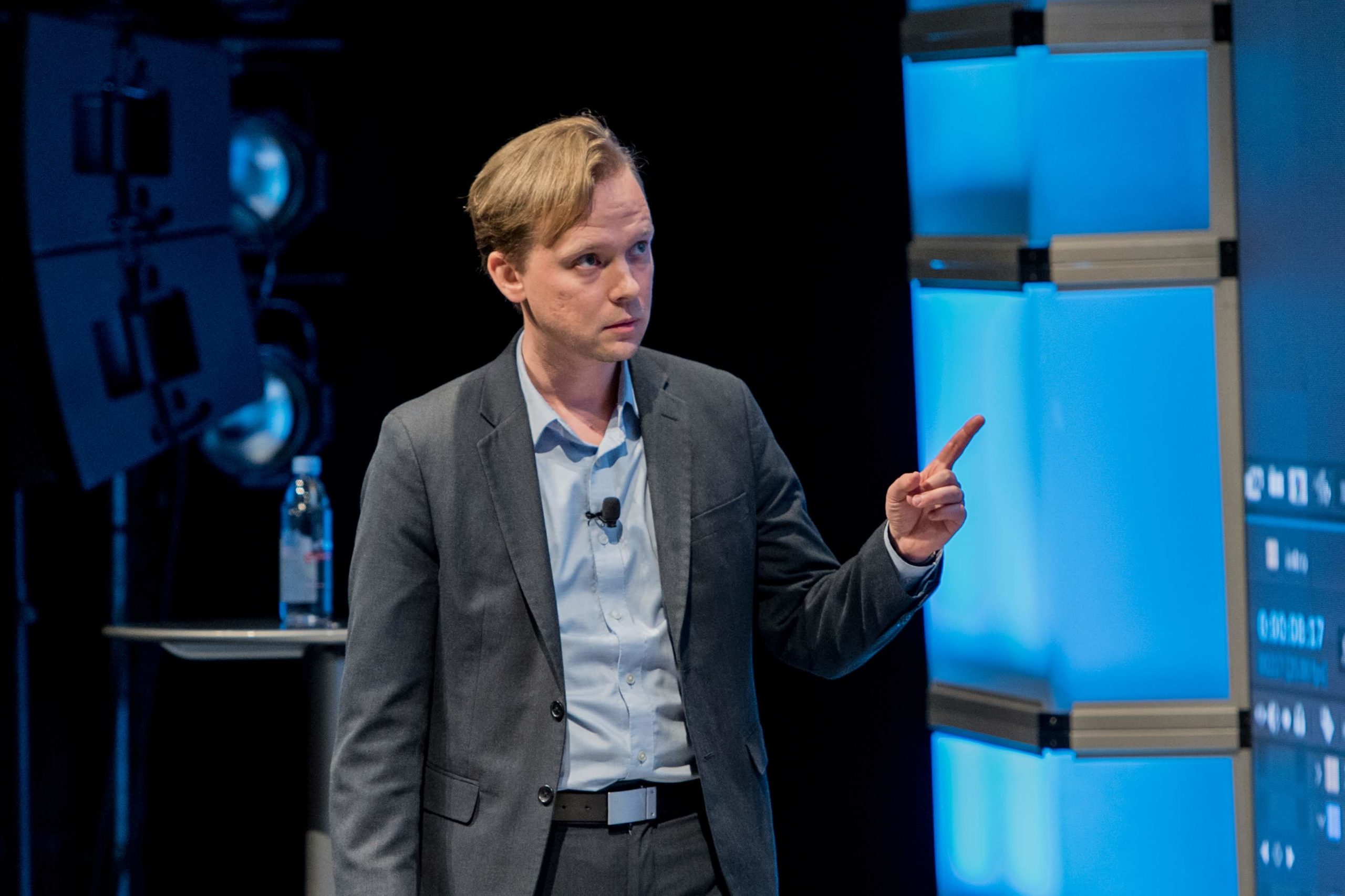
The picture below shows Adm. Harry Harris, while he served as the commander of the U.S. Pacific Command (PACOM) under the Obama administration, testifying in front of the Senate Armed Services Committee, pointing to a satellite image that CSIS provided him.

Adm. Harry Harris
Adm. Harris knew about China taking dredgers out to the sea, destroying coral reefs, and building military outposts in order to assert authority over its maritime neighbors long before CSIS made the evidence public. Only, earlier, he could not have addressed the issue publicly, let alone testify in front of Congress, since US intelligence reports are typically classified.
“The difference with this project and so many others from CSIS was that we built an entire website around these issues at the Asia Maritime Transparency Initiative. We did not bury these striking satellite photos in a report that languished on a congressperson’s desk,” says Paul Franz, who manages the production of innovative and engaging visual content at CSIS.
To this day, AMTI is cited as a leading source on Asian maritime legal and political issues.
Paul Franz as he presents at a Mapbox conference
Up against a world stuck in PDFs
As a former journalist, Franz is deeply aware of how powerful visuals, when presented well, translate into headlines. But when he jumped over to the nonprofit sector, it shocked Franz to see the dismal ways through which think-tanks were communicating important issues to their audiences.
“The dominant output of the ideas industry and think-tanks is the PDF. The world has moved on from this and audiences demand engagement that is not only cross-channel, but also multi-platform. It is not enough to take satellite images or maps and shove them inside a product like a PDF. No one will ever see that,” Franz stresses.
And while he recognizes that there’s always going to be an expert audience for deep dives into the written word, Franz is also cognizant of the fact that not everyone engages with content the same way as a researcher would.
“What organizations fail to understand is that this is not a zero-sum game. If the report is accompanied by a compelling video or interactive product, it doesn’t come at the expense of the report or the research. It all exists in a continuum of engagement. The report isn’t a tombstone,” he quips.
This is why as Director of Technology and Dracopoulos Chair in Creativity and Innovation, Franz has ensured that telling stories with maps and imagery – geostorytelling – becomes a core part of CSIS’s brand.
“We deal with heady stuff every day – major geopolitical issues of our time that shape the present and future of our world. Yet, we’re not journalists, novelists, or storytellers in the traditional sense. Unlike journalism, we can’t always rest on finding a compelling character to generate empathy and interest,” Franz points out.
“So, maps become the next best thing. Maps are familiar. They are engaging and fun. Maps transcend national languages. They are part of a common visual vocabulary that people can easily understand.”
In 2019, CSIS started a new video explainer series called ‘High Resolution’, orienting stories around the geospatial aspects of CSIS’s research. Franz and his team have produced 14 episodes to date, and by far, the series has been one of the most successful and most-watched products at CSIS – averaging an 80 percent completion rate and over 1 million views.
“To go from unread PDFs to this level of attention is all we could have asked for,” Franz smiles.
Pushing the envelope for maps
The success of ‘High Resolution’ also gives a nod to the inclusivity of the geospatial industry, proving that maps aren’t a province of cartographers or GIS professionals alone. “It shows that a video and motion designer can also have a seat at the table and a voice in geo,” Franz asserts, pointing to the emergence of tools like Google Earth Studio and the potential they hold for motion design, maps, and visualization.
“We think of maps as these static things – either an interactive image shown through an iframe or a still image. There’s so much room to keep pushing the envelope and incorporating the best of cinema – motion design, sound design, etc. – to make maps even more compelling.”
Does that list include virtual reality tools as well?
Not at the moment, Franz shrugs.
“At a recent geography meetup, I tried out Maxar’s CityBox to explore the locations of satellites. Beyond its initial ‘wow’ factor, I did not see much value to using it, especially from a storyteller’s perspective,” he explains.
“The question VR app developers really need to ask themselves is: What is the value-add? What can be done with native VR tools and technology that a ‘normal’ desktop or mobile experience cannot provide?”
For storytellers like Franz, immersion is everything. “If I can be fooled, even for one second, that I am actually standing on a corner of Washington, D.C., with a headset on, then I think VR will have reached a turning point. Right now, I still feel like I’m caught inside primitive attempts at early 3D visualizations of the 90s, with jagged edges, blurry images, and poorly extrapolated heights. For that matter, the VR geo apps I’ve tried are very one-dimensional. They’re yet to capture another critical part of visual storytelling: audio.”
Can the industry create a VR app that would transform geospatial in the same way Half-Life: Alyx revolutionized gaming? “We are not there yet. But I hope to be a part of that conversation and help lead us there.”
Talk about the novel coronavirus and its impact on the geospatial industry, and Franz is quick to mention that, if anything, the COVID-19 pandemic has made remote imaging technologies more valuable than ever. “If fieldwork and on-the-ground photography is restricted in the future or deemed too dangerous, then satellite imagery becomes ever more critical,” he says.
“I think this is also a golden opportunity for us to build a bigger tent for geo. I’ve been to too many talks and lectures where it’s obvious that the presenter is talking to his or her five colleagues who know as much as they do about GIS. That’s not what we need to do. We need to talk about geo in a way that’s effortlessly understandable to all.”
And that’s exactly what Franz and CSIS plan to continue doing – through stories that combine the best of other disciplines and use ideas from other industries to make geo better.