

Space is calling – banner of GLONASS program
GLONASS, or Global Navigation Satellite System, is Russia’s answer to GPS, providing real-time positioning and timing services globally. Initiated by the Soviet Union in 1976, it became fully operational in 1995. The system is vital for both military and civilian applications, ensuring independence from American GPS. GLONASS supports numerous devices across various sectors, including telecommunications, emergency services, and transportation, enhancing navigation accuracy worldwide.
“Unclear” intervention in Crimea and eastern Ukraine pushed a number of governments to apply sanctions against Russian individuals and businesses. The sanctions are strongly hitting Russian economy which moves into recession. Also Russian global satellite navigation system GLONASS will suffer. Due to restrictions in the delivery of radiation-resistant electronic components from the West, GLONASS satellite manufacturer will cancel the program for building the new type of satellites called GLONASS-K2.
Nikolai Testoyedov, CEO of Information Satellite Systems Reshetnev, told the Russian magazine Vestnik GLONASS:
After the two GLONASS-K1 satellites No. 11 and 12, we wanted to go for the launch of more advanced GLONASS-K2 devices. But, unfortunately, the plans had to be adjusted somewhat because of the sanctions restricting the delivery of radiation-resistant electronic components from the West. We have to put a hold on the in-depth development of technical and technological documentation and that delays us in terms of moving ahead by at least a year or two.
This will not affect the functioning of the system which had achieved 100 percent coverage, with the full orbital constellation of 24 satellites operational in 2011.
source: GPS World
Did you like this post about the GLONASS navigation system? Read more and subscribe to our monthly newsletter!

#


Next article
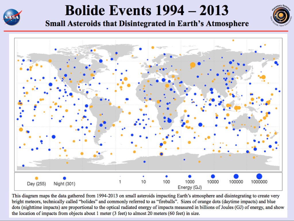

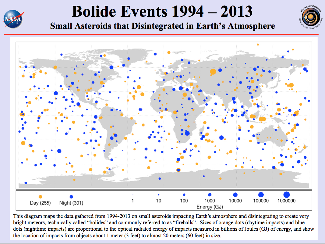
Asteroids entering the Earth’s atmosphere are very frequent occurrences summiting around mid August when the Earth is crossing the meteor shower associated with the comet Swift-Tuttle, during the so called Perseids days. Entering the atmosphere asteroids disintegrate due to friction and would burn up if they are small objects, which we can observe as small fireballs transecting the sky. Every day the Earth is bombarded by more than 100 tons of sand sized dust from space, only once a year an automobile-size asteroid enters the Earth’s atmosphere creating an huge and often explosive fireball, whereas asteroids of a certain size do not disintegrate completely before hitting the surface. The largest event within the last twenty years was a asteroid of around 20m size that entered the atmosphere near the city of Chelyabinsk in central Russia on February 15, 2013, exploding in the air before the asteroid hits the ground. The release of energy from that event corresponds to approximately 440.000 – 500.000 tons of TNT.
NASA’s NEO Observations Program
NASA’s Near Earth Object (NEO) Observations Program finds, tracks, and characterizes asteroids whose orbits bring them within approximately 50 million kilometers (31 million miles) of Earth’s orbit about the sun. It aims to find potentially harzadous asteroids that are expected to come close to the Earth. NEO claims to have detected already 96% of the estimated 1000 asteroids with 1km size and larger. The NEO Observation Program’s current objective is to find 90% of the 140m and larger sized objects that are around 25 times more frequent than asteroids of 1km size and thus more susceptible to hit the Earth.
Explaining the Map
However, the map at hand shows asteroids of 1m size and more that hit the Earth’s atmosphere within the past 20 years (1994 – 2013). Around 556 events of different energy impact were recorded indicated by the size of the dots. The colour refers to the time the event happened – orange color stands for daytime events and blue colour for nighttime events. The emitted radiant energy at each occurrence was recorded from which the total impact energy can be estimated using an empirical relationship: the smallest dot on the map presents 1 billion Joules of optical radiant energy, which is equivalent to around 5 tons of TNT. The size of the recorded asteroids ranges from 1m to 20m, smaller asteroids were not recorded due to the lack of radiant energy hitting the Earth.
So, think about what you wished when you observed your last falling star and if that wish has already been realised.
NASA Map
Did you like this post about mapping the asteroid hits? Read more and subscribe to our monthly newsletter!