How can satellite data add value for different construction stakeholders?

Part 2 in our EO Hub construction series
The construction industry, traditionally one of the slowest to embrace digital changes, has been making notable strides in recent years, with increasing interest in drone technology. But while UAVs are now commonly seen over modern construction sites, satellite data has not yet been adopted in any meaningful way.
However, the tool is emerging as a potential game-changer when it comes to large-scale and mega projects: while a few simple buildings can be easily monitored on foot, expansive mega projects, often spread over hundreds of kilometres, pose a unique challenge, exceeding the capabilities of traditional mapping or even drone technologies.
In this, the second in our three-part series on the use of satellite data in construction, we look in more detail at the myriad ways construction stakeholders can leverage satellite data across the entire construction lifecycle of these enormous sites.
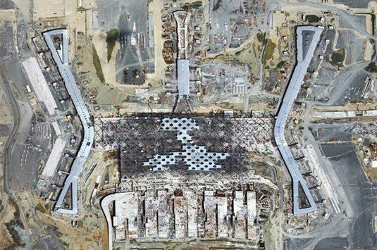
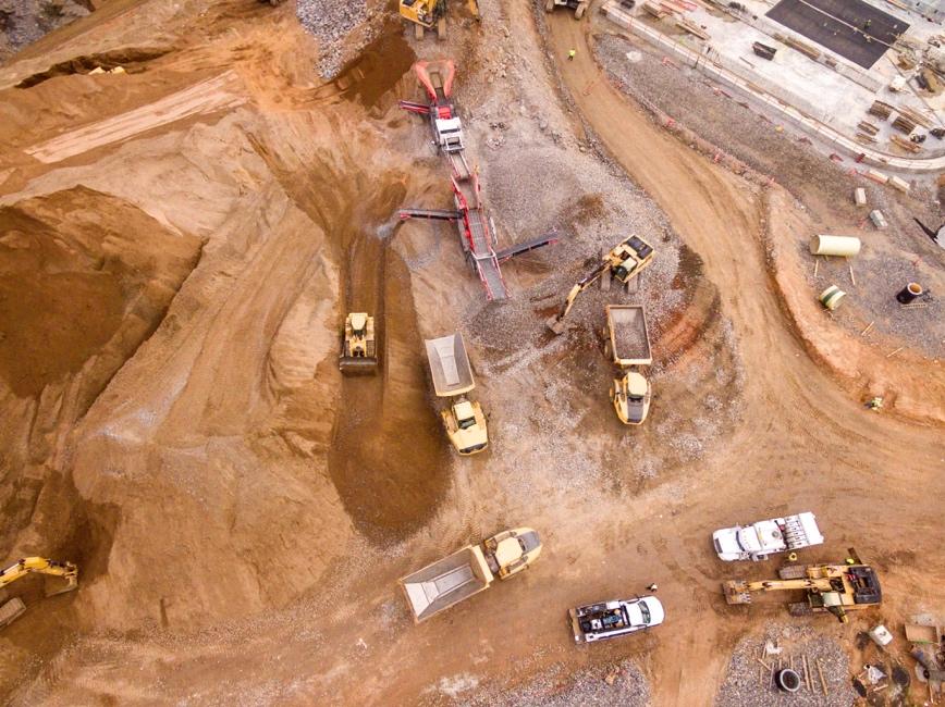
Satellite view of the construction of Istanbul airport — image from European Space Imaging
What kind of satellite data can be used by the construction industry?
When it comes to satellite imagery for construction, there is a simple rule: the higher the resolution, the better. And with 30cm resolution now available from several satellite providers, the data available is more precise than ever. Furthermore, this can be enhanced to 15cm by super resolution, which, although it cannot add any detail missing from the original image, significantly improves its readability by both humans and machines.
However, there are other facets to satellite data which improve its usability for construction stakeholders. Among the most notable are improved elevation accuracy and orthorectification.

0.5 elevation accuracy: The degree of accuracy in measuring elevations is crucial for understanding topographical variations across large construction sites, and satellite data is now accurate to within half a meter (0.5m). This degree of accuracy ensures that designers, architects, engineers, and contractors have a reliable and nuanced understanding of the terrain. This facilitates more informed decisions in the project planning and design phases, allows for precise calculation of earthwork quantities, better predictions of drainage patterns, and a detailed understanding of the site’s environmental and geotechnical conditions. Moreover, with the advent of Building Information Modeling (BIM) and other digital tools, highly accurate elevation data becomes even more vital, as it leads directly to a more realistic representation.
Orthorectified imagery: Orthorectification is a process that removes the effects of image distortion due to perspective, tilt, and terrain relief. It is created by calculating the nadir view of every pixel in the image, with the resulting ‘orthophotos’ having the aesthetics of a photograph and the positional accuracy of a map. Orthorectified images always show the earth’s surface from the same nadir angle, which is critical for change detection and comparing timeseries of satellite data with each other, and have a uniform scale, essential for mapping and monitoring. Marketplaces like UP42 offer orthorectified images as well as orthorectification services.
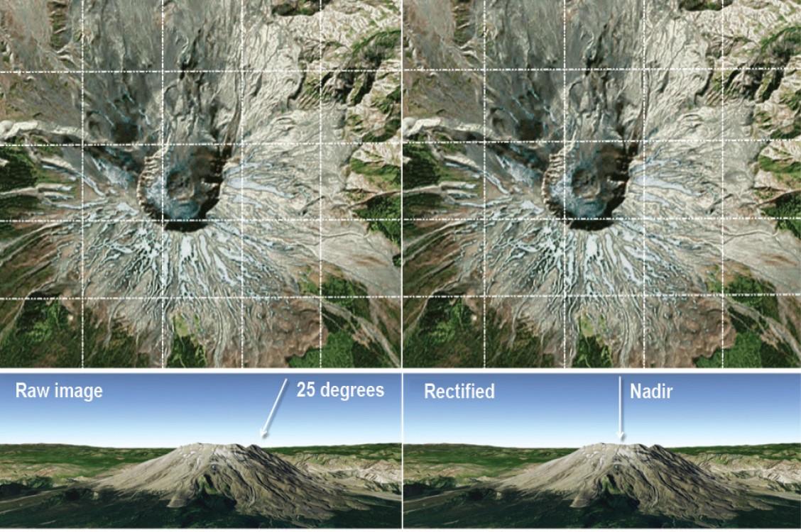
Before and after orthorectification — image from Esri
Satellite Data adds value for every stakeholder, throughout the construction lifecycle
It’s an observed trend that construction projects—especially large-scale and mega projects—often experience budget and cost overruns. Such projects are typically very ambitious in their scope, and pose inherent management challenges due to both their engineering complexity and sheer geographical spread. Without comprehensive data and appropriate analytical methods, effective management becomes an uphill task. Continuous situational awareness is therefore essential—and in this context, satellites have the potential to add transformative capabilities to the construction sector as a high-level management tool. They can also be complemented by the use of drones, which remain a key engineering instrument for capturing detailed measurements.
However, it’s important to note that neither technology can entirely replace the precision and expertise of land surveyors and on-site supervision. Combining traditional methods with modern data collection tools ensures stakeholders are equipped with current information, facilitating prompt and informed decision-making. This proactive approach aids in risk mitigation, ensuring projects remain on schedule and within budget.
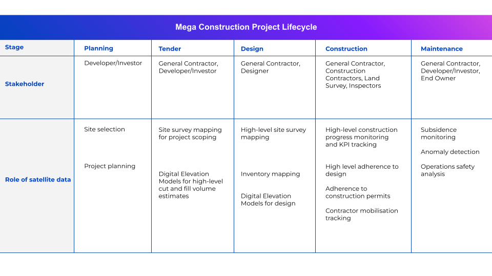
This table illustrates how satellite data comes into play for different stakeholders at different stages of the construction lifecycle:
For developers and investors, satellite data presents a wealth of accurate, detailed information about a site and its surroundings, in an easily-readable visual format. Developers can therefore make informed decisions regarding a project’s feasibility—and its potential profitability. As the project unfolds, these stakeholders can employ satellite data to ensure that progress is in line with budget and timeline, aiding in the early identification of potential hiccups and minimizing financial risk.
General contractors can incorporate near-real-time satellite data into their management process to help them coordinate construction activities, such as the movement and placement of equipment and materials, with precision. Furthermore, they can monitor the ongoing progress and quickly spot any deviations or issues. This results in enhanced productivity, cost efficiencies, and improved quality control.
For designers, including architects and engineers, satellite data can be an unparalleled tool for site analysis, shedding light on factors including topography, land use, environmental nuances, and surrounding infrastructure. This wealth of information can be instrumental in helping designers draw up plans for constructions that work in harmony with the existing environment.
Construction companies could derive similar immediate benefits from satellite data to general contractors, with applications in project management and quality control. However, these companies can also utilise satellites in their long-term strategic planning, whether scoping out potential locations for future projects, tracking market changes, or post-completion assessment of processes and projects.
Land surveyors may be able to use satellite data to minimize dependence on exhaustive and costly ground surveys, as high-definition satellite imagery can provide intricate details about a site’s topography. However, it’s essential to bear in mind that satellite data, while hugely valuable, might not always serve as a complete substitute for on-the-ground surveys—especially where pinpoint accuracy is required or where surveying extends to subterranean features.
For inspectors, satellite data can be instrumental in ensuring that construction activities abide by environmental and regulatory requirements. Inspectors can use the data to validate that the physical infrastructure aligns seamlessly with approved designs. Furthermore, in the event of inappropriate or illegal practices, like unauthorized waste disposal or unauthorized construction sprawls, satellite images provide clear evidence.
Lastly, for owners, satellite data provides a panoramic and comprehensive view of their assets. From a macro lens helping to monitor progress during the initial planning and construction phases to a meticulous tool for ongoing facility management, owners can monitor structural health, coordinate maintenance schedules, and even gauge potential threats from natural disasters.
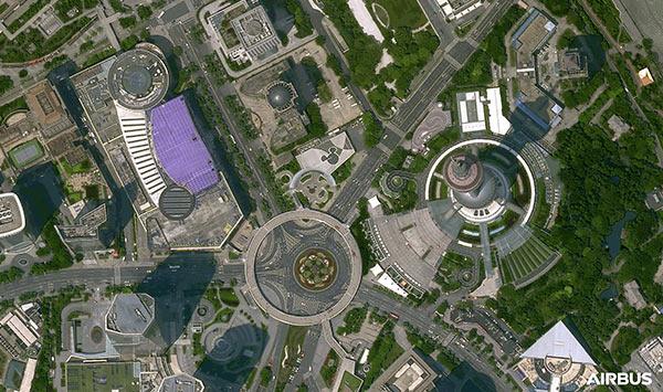
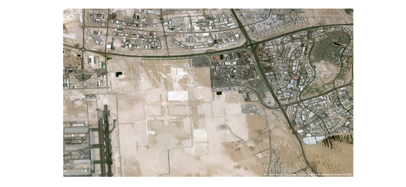
Satellite imagery of Shanghai. Image from Airbus
In essence, when it comes to high-level data collection over a vast geographical area like a construction mega project, satellites are the only way to map the entire site. The technology facilitates informed decision-making and transparency throughout the construction lifecycle, ensuring all stakeholders are both well informed and also held accountable. It streamlines coordination, enhances efficiency and precision, and ultimately leads to more successful outcomes for everyone involved.
A future of enhanced stakeholder confidence
The world of construction is fraught with challenges, but the integration of satellite data is poised to be a game-changer, particularly for the management of expansive mega projects. It offers unparalleled situational awareness, facilitating informed decision-making and risk management across all phases of the construction lifecycle. Every stakeholder, from property developers to environmental inspectors, can harness its potential: beginning with the careful tasks of site selection and project design, through the strategic orchestration of activities and compliance monitoring, right up to and including long-term facility management.
With satellite data in their toolkits, construction companies can benefit from enhanced project management, better quality control, and improved safety—all of which translates into successful projects delivered on time and within budget. In the final segment of our series, we will delve deeper into precisely how this is done, by considering which construction KPIs can be measured using satellite data.
Did you like the article? Read more and subscribe to our monthly newsletter!

#Categories
Next article
Exploring the role of satellite and drone data in construction progress monitoring
Part 1 in our EO Hub construction series
Historically, the construction industry has lagged behind other sectors when it comes to digitization. However, technological advances are increasingly permeating the construction landscape, with drone technology in particular gaining significant attention.
Recognized for their ability to capture volumetric measurements of earthworks, and with a typical resolution of around 3cm, drones are now a key engineering tool. They can also provide enhanced situational awareness for small to midsize construction sites, as high-resolution data can be captured and processed into orthomosaics and high-density 3D point clouds in as little as 24-48 hours. This has led to the wide adoption of drones by the construction industry.
However, when the area of interest expands to tens—or even hundreds—of kilometers, as is common in mega projects, challenges arise, and the shortcomings of drones are exposed. This is where the power of satellite data comes into play. With 30cm resolution data now available from several constellations, this technology has the potential to perform a significant role for the industry—provided construction stakeholders can overcome their skepticism.
As we embark on a three-part series exploring the potential use of satellite imagery in the construction industry, we begin by comparing the use of drones and satellite data.
Drones: A versatile data-collection tool
Drone technology is already widely utilized in the construction industry. High-resolution aerial imagery and 3D mapping of construction sites facilitate the collection of crucial data, which can add enormous value for multiple stakeholders.
For example, drones can be used in planning, for verification of site conditions or making environmental impact assessments. During construction, they can be used for detailed engineering calculations, including volumetric cut-and-fill measurements. Drones also play a vital role in monitoring schedule adherence, budget management, quality control, and compliance, and can be used for the detection and rectification of planning and execution errors.
One of the most important benefits of drones is in increasing safety. Construction is one of the most dangerous industries globally, with construction workers 3–4 times more likely to die from on-the-job accidents than those in other sectors—rising to 6 times higher in the developing world. Drones can significantly mitigate the risk of injury and death, by enabling firms to access and capture imagery in dangerous, hard-to-reach locations without on-the-ground human involvement.
With companies like Propeller Aero providing data processing and analysis platforms, plus hardware for improving the accuracy of drone surveys, organizations don’t need team of experts to incorporate drones into their workflow. Furthermore, with drones becoming more and more affordable, the entry barrier to their use is lower than ever.
In short, drones are the perfect tool for remotely monitoring sites up to several square kilometers, and with technology advancing rapidly, they have become indispensable to the construction industry. However, they do have limitations. They are not suitable for use in adverse weather conditions—and, most significantly, are not practical for projects over 10-25km2 in area.
Satellites: The macro perspective
Satellites, on the other hand, provide a high-level perspective. Although they may not prove cost-effective for surveying areas smaller than 10-20km2, they hold immense promise for mega projects. These sites can sometimes be hundreds of kilometers in size, and satellites can offer a macro-level overview which are virtually impossible with traditional methods.
Resolution limitations may prevent cm-level surveying, but with resolution of 30cm (or even 15cm with super resolution) now available, the applications of satellite data are rapidly expanding. For example, satellite imagery can aid in the planning stage when investigating potential sites and assessing environmental impacts—UP42 is an example of a platform which gives construction companies a cost-effective way to conduct planning and feasibility studies through its historic collections.
During construction, satellites can be tasked to help firms to monitor productivity metrics on a large scale, or to measure ground deformation as a result of tunneling. Furthermore, satellite imagery can enhance transparency and trust, improving stakeholder communication.
Source: Airbus
Of course, as with drones, satellites have their limitations. They are not ideal for monitoring long, linear projects like roads, and depending on the type of imagery required, they may not be effective when dealing with cloud cover.
Complementary Solutions: Drones and Satellites in construction progress monitoring
By combining the use of drones and satellite technology, construction firms can create a robust, multi-layered system for project monitoring and data-gathering. Each technology compensates for the other’s limitations: the broader coverage of satellite data counterbalances the restricted range of drones, while the high-resolution data from drones supplements the less detailed satellite data.
This synergy between the two technologies can ensure comprehensive progress monitoring, enhance decision-making, and sharpen predictive capabilities. When used in tandem, they can significantly reduce (although not eliminate) the need for on-the-ground monitoring, which can increase safety and efficiency, and potentially reduce costs. With the rapid advances being made in data analysis, unparalleled insights are available to organizations willing to embrace the technology.
The table below summarizes the technical differences between drone and satellite data, and demonstrates clearly that they are complementary, rather than competing technologies:

Conclusion
As the digital transformation unfolds, both drones and satellites hold vast potential for the construction industry, and have the potential to work synergistically as invaluable tools for managing large-scale projects. These technologies herald a revolution in construction progress monitoring, driving efficiency, improving quality, and ensuring that complex mega projects can be completed successfully.
However, challenges remain to widespread adoption of satellite data—not least, skepticism within the industry about both its capabilities and affordability. It’s true that historically satellite data has been prohibitively expensive, with resolution only suitable for the highest level of analysis. However, the industry has come a long way in a short time. Earth observation data providers and thought leaders in the space have a crucial role to play in communicating the giant leaps forward that satellites have made, in terms of resolution, tasking abilities, and in affordability.
Did you like the article? Read more and subscribe to our monthly newsletter!