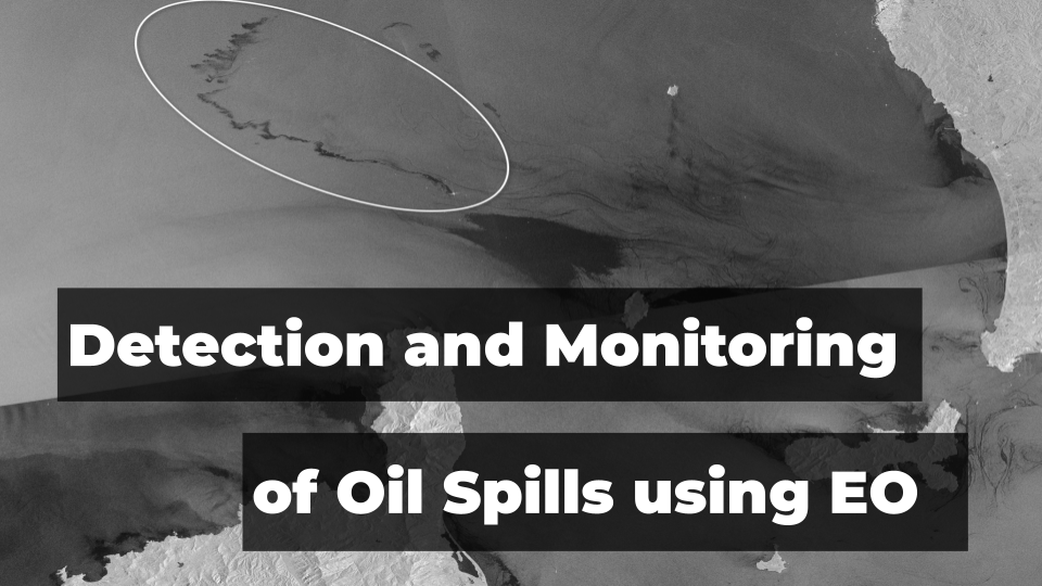
Leveraging Satellite Technology for Advanced Detection and Monitoring of Oil Spills

The critical importance of marine ecosystems cannot be overstated, given their vast contributions as significant nutrient reservoirs and oxygen providers. These ecosystems also sustain ecological equilibrium, rendering their preservation indispensable. However, these vital systems are perennially threatened by natural and man-made disasters, with oil spills representing one of the most devastating and frequent occurrences. Studies show that approximately 50,000 tons of crude oil find their way into our oceans annually, painting a grim picture of marine pollution.
Oil spills predominantly occur during the marine transportation of oil. Despite numerous international environmental regulations and stringent operating procedures to prevent such catastrophes, the menace of oil spills persists. The types of oil spills range from light oils that, despite their rapid evaporation, pose high toxicity to heavy oils that, while less toxic, persist in the environment for an extended time. Once released into the water, these oils swiftly spread, forming a thin surface layer known as an “oil slick.” Amplified by wind, waves, and currents, spills can expand over vast areas, inflicting severe environmental damage.
Harnessing Satellite Technology for Oil Spills
To mitigate the damage to marine life and human health, oil spills must be detected promptly and monitored carefully to avert subsequent environmental hazards. The evolution of technology has engendered innovative tools and methodologies to achieve rapid and accurate detection and monitoring of oil spills. Among these, remote sensing satellite imagery has proven particularly effective, providing oceanographers and responders with relevant data to detect, track and monitor oil spills in near real-time.
Satellites are the eyes in the sky that can help us identify problems occurring in even the most difficult-to-reach areas on Earth. Oceans, for instance, are too vast to be monitored effectively through any other means. Remote sensing technology can help responders get the visual data required to understand the extent of the disaster over huge areas. Such data can be then combined with other data sources to build advanced analytical workflows using different remote sensing tools and platforms.
Researchers typically rely on both optical and SAR data types for in-depth analysis of the location, shape, size, colour, and orientation of an oil spill at any given time. The baseline analysis starts with passive optical sensors. RGB optical data from satellites such as Landsat or Sentinel-2 allow the detection of sunlight reflected by oil, which can be differentiated from the surrounding water in clear weather conditions. Particularly useful, however, are Infrared (IR) and Near-Infrared data, which have proven to be very effective in the non-visual spectrum of light.
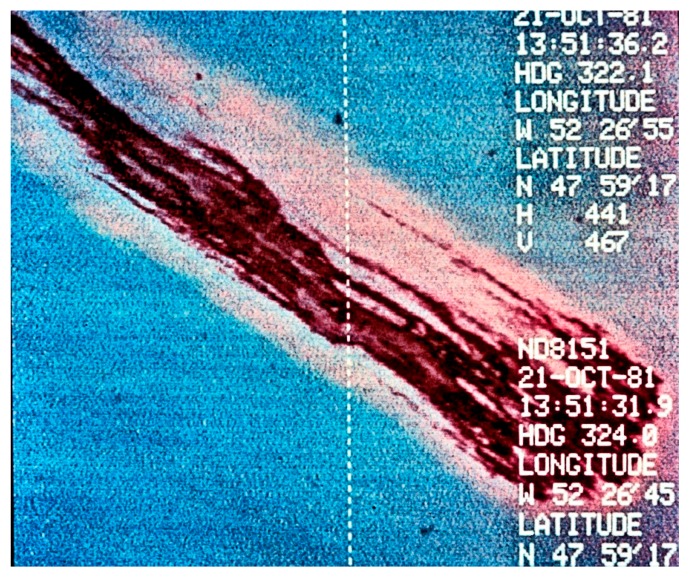
Source: IR example of the oil slick (Photo from Environment Canada)
Visible spectrum imagery is useful but can be obstructed by weather and sun glint, therefore, scientists more often rely on Synthetic Aperture Radar (SAR) data, which can provide data independently of sunlight or weather conditions. Satellite radar is particularly useful for monitoring the progression of oil spills because the presence of oil on the sea surface dampens down wave motion. Since radar basically measures surface texture, oil slicks show up well–as black smears on a grey background.
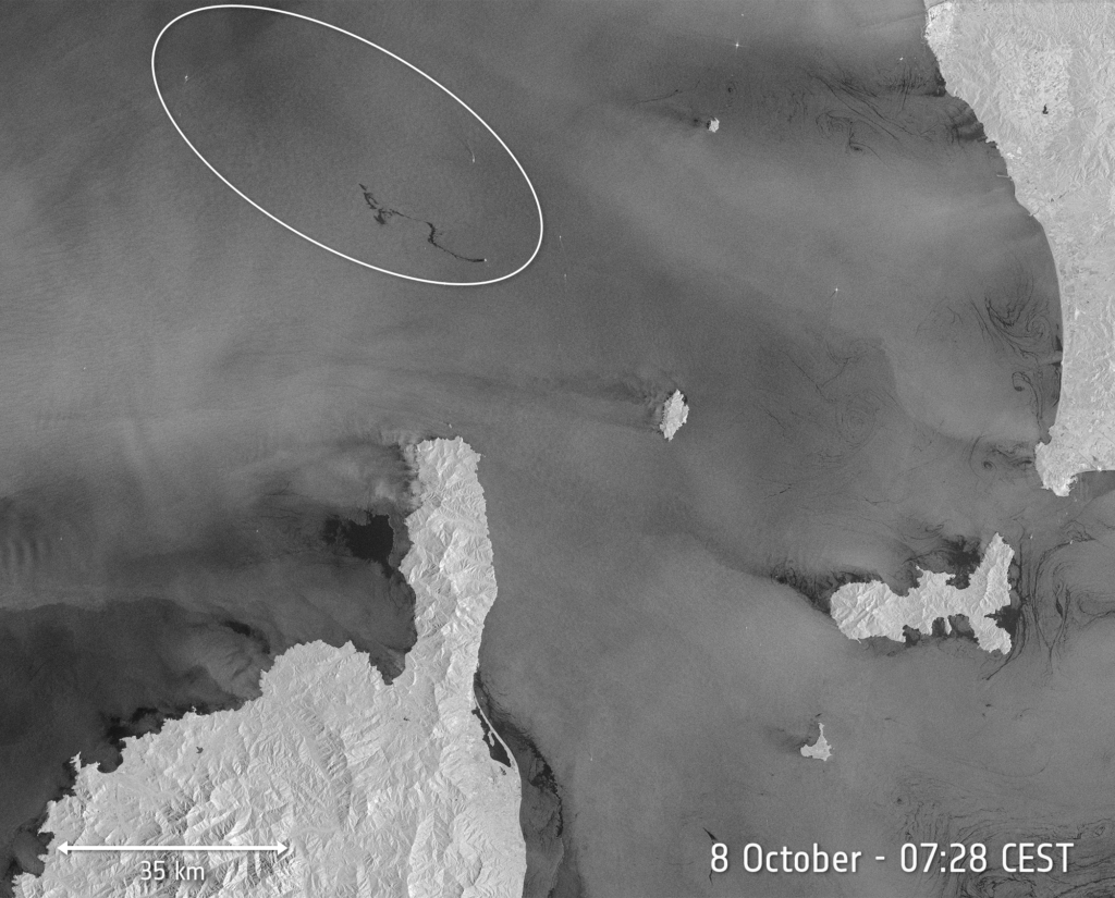
Source: ESA
Another challenge for scientists is estimating the thickness of an oil slick. One of the most common techniques is to observe its “colour” and assign a thickness based on established guidelines for thickness ranges. Tables and guidelines for visual estimation of oil spill volumes are published by the National Oceanic and Atmospheric Administration (NOAA) on their response and restoration website.
Monitoring Changes and Predicting Trajectories
Satellite technology is an invaluable tool for monitoring changes in oil slicks, enabling responders and oceanographers to accurately predict the oil’s future location. By updating oil spill trajectory models with the latest satellite observations of surface oiling extent, planning of clean-up actions becomes more effective.
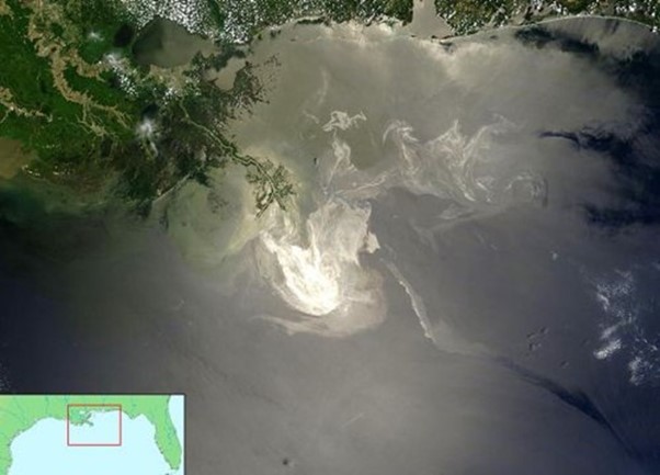
The significance of satellite imagery was vividly demonstrated during the Deepwater Horizon oil spill, also known as the “BP oil spill,” which began on April 20, 2010, off the United States Gulf of Mexico coast. With an estimated discharge of 4.9 MMbbl (Million Barrels), this catastrophe marked the largest marine oil spill in the petroleum industry’s history and one of the most significant environmental disasters globally.
Satellite imagery played a critical role in containing this disaster by measuring the spill’s extent and identifying areas off-limits to fishing due to oil contamination. In addition, the National Oceanic and Atmospheric Administration (NOAA) utilized satellite data to monitor circulation patterns in the Gulf of Mexico, closely track the slick’s position relative to the Loop Current, and assess the risk of oil spread to other coasts.
Such cases highlight the importance of having highly accurate satellite data as provided by platforms like UP42.
Source: NOAA
Preventing Oil Spills
It has been well established that satellite technology has all the capabilities to provide responders with a comprehensive and timely view of the effects of oil spills. Satellite technology facilitates quick and accurate detection of the presence of oil spills, thereby paving the way for a rapid and more effective response. It is essential to reduce the risk of oil spill disasters to protect the environment and reducing economic losses.
There is ongoing research to further refine remote sensing satellite technology to conduct oil spill surveillance, identify pollution causes, and detect minor spills before they escalate into widespread disasters. This preventative strategy, known as oil spill surveillance, forms a critical component of oil spill disaster management, further highlighting the role of satellite technology in environmental protection.
Did you like the article? Read more and subscribe to our monthly newsletter!


#Categories


Next article
A look at the ways in which satellites are used to monitor and forecast weather
Weather affects every aspect of our lives. Accurate forecasts are not only useful for day-to-day planning, but also crucial for industries such as aviation, logistics, agriculture, and emergency management. These days, we have forecasts at our fingertips, delivered through simple iconography in smartphone apps and widgets. However, this user-friendly delivery method means we often take it for granted, and don’t consider the intricate upstream and downstream processes that make weather forecasting possible.
In recent years, the use of satellites has revolutionized meteorology, enabling the observation of weather patterns on a global scale. This advancement has led to more accurate predictions than ever before—not to mention more timely warnings of dangerous conditions.
The science of weather forecasting
The current trend of representing weather through static icons on a smartphone screen does a lot to disguise the complexity of these dynamically changing systems. Weather is driven by thermodynamics: temperature differences between the poles and tropics, combined with the rotation of the Earth, influence the flow of air and water vapor across differentially heated parts of the planet’s surface. This fluid flow is also affected by factors such as oceans, land masses, and mountains. Weather forecasting relies on numerical weather prediction (NWP) models, which are mathematical models that simulate this fluid behavior.
‘Deterministic forecasting,’ which gives a single forecast outcome, is fraught with challenges, both due to chaos theory and the limitations of NWP models, and can only be relied on up to a few days in advance. Meteorologists, therefore, often use ‘ensemble forecasting’: By simulating different conditions, a range of possible outcomes can be predicted, together with their probability, making a forecast fairly reliable up to about two weeks—and despite long-running jokes about their accuracy (or lack thereof), weather forecasts have become incredibly precise over time.
However, none of this is possible without accurate data to input into the models. Measurements taken include atmospheric factors like precipitation, precipitable water (the total amount of potential precipitation in a column of the atmosphere), and wind direction and speed, but also ground-level factors, like sea surface temperature and other oceanic properties. This data comes from various sources, including weather balloons, ground stations—and, increasingly, satellites.
Satellite tools for weather forecast
Today, there are approximately 200 meteorological satellites in orbit, and the vast majority of them can be classified into two types. The first are polar-orbiting satellites, which travel around the Earth at low altitudes, from pole to pole, monitoring the entire planet as it rotates, over a period of 10 days to 1 month. Geostationary satellites, meanwhile, orbit at a high altitude over the equator, moving at the same speed as Earth’s rotation, thereby continuously monitoring a specific section of the planet. Both types play essential roles in weather forecasting.
Weather satellites are equipped with various instruments, including sensors for temperature and humidity, cameras for capturing images, and tools for measuring other atmospheric conditions like wind speed and precipitation. Generally, they are designed to be multi-functional, and carry a combination of different sensors to provide comprehensive observations. Some, however, may focus on a specific variable. For instance, the Global Precipitation Measurement (GPM) mission and Tropical Rainfall Measuring Mission (TRMM) both focus on precipitation data.
Some of the sensor types used by weather satellites
|
Advantages of satellites in monitoring and weather forecast
Perhaps the single most significant advantage brought about by weather satellites is their ability to monitor conditions over the oceans. They account for over 70% of the planet’s surface, but before the space age, weather observations over the Earth’s oceans were sparse, with ocean-going ships and buoys providing only limited measurements. Satellites have given meteorologists the ability to monitor weather over the entire surface of the planet, which has led to a far greater understanding of global weather patterns and, consequently, significant improvements in forecasting.
The use of satellites in weather forecasting offers other advantages over conventional means. They enable monitoring of remote regions including mountains, deserts and rainforests, and also permit simultaneous observation of multiple areas, all of which contributes vital information about weather systems and long-term predicitons. They can also assist with short-term prediction, by monitoring and providing real-time data on atmospheric changes, such as the development of storms or clouds, and identifying fog formation.
Satellites are also the best means by which to track storm movements and predict their path and intensity, by detecting changes in pressure, and wind direction and speed. They can therefore help to warn of potentially devastating consequences, like floods, wildfires, destruction to assets, or danger to lives. Hurricane Sandy provided a dramatic real-life example of the benefits of satellites in weather prediction, when NASA’s polar-orbiting satellites were able to predict the storm’s very unusual ‘left-hook’ movement and forecast its landfall a week in advance.
The state of the industry
Historically, the sector has been driven by government agencies or intergovernmental bodies. EUMETSAT (European Organisation for the Exploitation of Meteorological Satellites) operates a series of geostationary meteorological satellites, Meteosat, and also two polar-orbiting satellites, MetOp, for weather forecasting and climate monitoring. The United States National Oceanic and Atmospheric Administration (NOAA) also operates a number of satellites, including the geostationary COSMIC-2 series focused on the equator. However, NOAA has recently turned to private companies GeoOptics and Spire to help fill gaps in satellite coverage, particularly closer to the poles.
GeoOptics provides environmental data to commercial partners as well as governments. The company has a constellation of nanosatellites called CICERO (Community Initiative for Cellular Earth Remote Observation), the first—and so far the only—satellite constellation providing high-quality radio occultation data. Spire’s Lemur constellation has over 100 satellites, one of the largest constellations in existence, and the company provides weather data as one of a number of solutions, also using radio frequency technology.
There is a growing commercial market for satellite data, creating a more diverse and dynamic sector. For instance, marketplaces like UP42 now host data and analytics related to weather, making it easy to access information for those who need weather data for a small project or area of interest. UP42’s weather data is provided in partnership with Meteomatics.
Opportunities and challenges for the meteorological satellite sector
Space has become more accessible than ever before, but a satellite launch is still a costly endeavor. The market for weather data is limited, so investors are hesitant to fund startups in this domain, and although there has been a significant increase in the number of private satellites in general, not enough companies are focusing on weather forecasting. Weather companies themselves face the challenge of balancing limited budgets. Furthermore, there are challenges to do with technology on the ground: As satellites are producing more data, with increased spatial resolution, the need for greater data storage and processing speeds also grows.
One of the most promising opportunites for satellite weather forecasting has been presented by advances in small satellite technology and cubesats. Weather satellites have traditionally been huge, which contributes significantly to the cost of their launch. Small satellites—like NASA’s ‘Raincube’ and ‘Windcube’, or those being developed by Orbital Micro Systems (OMS), PlanetiQ, and —could dramatically increase affordability, leading to more constellations capable of filling measurement gaps.
Meanwhile, as machine learning and artificial intelligence continue to develop, they will play an increasingly crucial role, improving the models used in weather prediction. Developments in quantum computing could lead to faster computers which, coupled with advanced AI, can help to process the vast amount of data collected by satellites.
Satellites are likely to be used in combination with traditional measurement techniques for some time yet. For example, UP42’s weather data source combines satellite data with ‘over 10,000 weather stations dotted across the globe.’ Climate and weather specialist Climavision provide what they claim to be ‘the most technologically advanced site-specific weather forecasting system, with data gathered not just from satellites but also an overlapping network of proprietary low-atmosphere radars.
Conclusion
Emerging technologies hold great promise for the future of weather forecasting, but there are still several hurdles to overcome to fully realize their benefits, according to acclaimed meteorologist Dr. Marshall Shepherd: The industry needs higher resolution precipitation data, more comprehensive wind information, and a deeper understanding of internal hurricane dynamics—especially over oceans. There is also apparently a data gap for precipitation and water vapour measurements in the ‘boundary layer,’ the first kilometer of the atmosphere. Finally, there needs to be improvement in the way weather information is communicated to people, so that they know when and how to act when faced with extreme weather events. These are not all problems that can be solved by satellites.
Nevertheless, the field of satellite-based weather forecasting has made significant strides in recent years, and there’s no doubt that as technology continues to improve, the sector will become increasingly important. Climate change is bringing more extreme and unpredictable weather events, with weather-related disasters increasing fivefold over the past 50 years. Surging populations in the developing world are making even more people vulnerable, so it’s crucial to provide early warnings for floods, hurricanes, and other natural disasters.
Investing in satellite technology for weather forecasting will not only save lives but also help communities better prepare for and adapt to our changing climate. With ongoing advancements and a growing understanding of the challenges faced by the industry, the future for satellite-based weather forecasting looks sunny.
Did you like the article? Read more and subscribe to our monthly newsletter!