A look at the ways in which satellites are used to monitor and forecast weather

Weather affects every aspect of our lives. Accurate forecasts are not only useful for day-to-day planning, but also crucial for industries such as aviation, logistics, agriculture, and emergency management. These days, we have forecasts at our fingertips, delivered through simple iconography in smartphone apps and widgets. However, this user-friendly delivery method means we often take it for granted, and don’t consider the intricate upstream and downstream processes that make weather forecasting possible.
In recent years, the use of satellites has revolutionized meteorology, enabling the observation of weather patterns on a global scale. This advancement has led to more accurate predictions than ever before—not to mention more timely warnings of dangerous conditions.
The science of weather forecasting
The current trend of representing weather through static icons on a smartphone screen does a lot to disguise the complexity of these dynamically changing systems. Weather is driven by thermodynamics: temperature differences between the poles and tropics, combined with the rotation of the Earth, influence the flow of air and water vapor across differentially heated parts of the planet’s surface. This fluid flow is also affected by factors such as oceans, land masses, and mountains. Weather forecasting relies on numerical weather prediction (NWP) models, which are mathematical models that simulate this fluid behavior.
‘Deterministic forecasting,’ which gives a single forecast outcome, is fraught with challenges, both due to chaos theory and the limitations of NWP models, and can only be relied on up to a few days in advance. Meteorologists, therefore, often use ‘ensemble forecasting’: By simulating different conditions, a range of possible outcomes can be predicted, together with their probability, making a forecast fairly reliable up to about two weeks—and despite long-running jokes about their accuracy (or lack thereof), weather forecasts have become incredibly precise over time.
However, none of this is possible without accurate data to input into the models. Measurements taken include atmospheric factors like precipitation, precipitable water (the total amount of potential precipitation in a column of the atmosphere), and wind direction and speed, but also ground-level factors, like sea surface temperature and other oceanic properties. This data comes from various sources, including weather balloons, ground stations—and, increasingly, satellites.
Satellite tools for weather forecast
Today, there are approximately 200 meteorological satellites in orbit, and the vast majority of them can be classified into two types. The first are polar-orbiting satellites, which travel around the Earth at low altitudes, from pole to pole, monitoring the entire planet as it rotates, over a period of 10 days to 1 month. Geostationary satellites, meanwhile, orbit at a high altitude over the equator, moving at the same speed as Earth’s rotation, thereby continuously monitoring a specific section of the planet. Both types play essential roles in weather forecasting.
Weather satellites are equipped with various instruments, including sensors for temperature and humidity, cameras for capturing images, and tools for measuring other atmospheric conditions like wind speed and precipitation. Generally, they are designed to be multi-functional, and carry a combination of different sensors to provide comprehensive observations. Some, however, may focus on a specific variable. For instance, the Global Precipitation Measurement (GPM) mission and Tropical Rainfall Measuring Mission (TRMM) both focus on precipitation data.
Some of the sensor types used by weather satellites
|
Advantages of satellites in monitoring and weather forecast
Perhaps the single most significant advantage brought about by weather satellites is their ability to monitor conditions over the oceans. They account for over 70% of the planet’s surface, but before the space age, weather observations over the Earth’s oceans were sparse, with ocean-going ships and buoys providing only limited measurements. Satellites have given meteorologists the ability to monitor weather over the entire surface of the planet, which has led to a far greater understanding of global weather patterns and, consequently, significant improvements in forecasting.
The use of satellites in weather forecasting offers other advantages over conventional means. They enable monitoring of remote regions including mountains, deserts and rainforests, and also permit simultaneous observation of multiple areas, all of which contributes vital information about weather systems and long-term predicitons. They can also assist with short-term prediction, by monitoring and providing real-time data on atmospheric changes, such as the development of storms or clouds, and identifying fog formation.
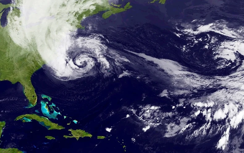
Satellites are also the best means by which to track storm movements and predict their path and intensity, by detecting changes in pressure, and wind direction and speed. They can therefore help to warn of potentially devastating consequences, like floods, wildfires, destruction to assets, or danger to lives. Hurricane Sandy provided a dramatic real-life example of the benefits of satellites in weather prediction, when NASA’s polar-orbiting satellites were able to predict the storm’s very unusual ‘left-hook’ movement and forecast its landfall a week in advance.
The state of the industry
Historically, the sector has been driven by government agencies or intergovernmental bodies. EUMETSAT (European Organisation for the Exploitation of Meteorological Satellites) operates a series of geostationary meteorological satellites, Meteosat, and also two polar-orbiting satellites, MetOp, for weather forecasting and climate monitoring. The United States National Oceanic and Atmospheric Administration (NOAA) also operates a number of satellites, including the geostationary COSMIC-2 series focused on the equator. However, NOAA has recently turned to private companies GeoOptics and Spire to help fill gaps in satellite coverage, particularly closer to the poles.
GeoOptics provides environmental data to commercial partners as well as governments. The company has a constellation of nanosatellites called CICERO (Community Initiative for Cellular Earth Remote Observation), the first—and so far the only—satellite constellation providing high-quality radio occultation data. Spire’s Lemur constellation has over 100 satellites, one of the largest constellations in existence, and the company provides weather data as one of a number of solutions, also using radio frequency technology.
There is a growing commercial market for satellite data, creating a more diverse and dynamic sector. For instance, marketplaces like UP42 now host data and analytics related to weather, making it easy to access information for those who need weather data for a small project or area of interest. UP42’s weather data is provided in partnership with Meteomatics.
Opportunities and challenges for the meteorological satellite sector
Space has become more accessible than ever before, but a satellite launch is still a costly endeavor. The market for weather data is limited, so investors are hesitant to fund startups in this domain, and although there has been a significant increase in the number of private satellites in general, not enough companies are focusing on weather forecasting. Weather companies themselves face the challenge of balancing limited budgets. Furthermore, there are challenges to do with technology on the ground: As satellites are producing more data, with increased spatial resolution, the need for greater data storage and processing speeds also grows.
One of the most promising opportunites for satellite weather forecasting has been presented by advances in small satellite technology and cubesats. Weather satellites have traditionally been huge, which contributes significantly to the cost of their launch. Small satellites—like NASA’s ‘Raincube’ and ‘Windcube’, or those being developed by Orbital Micro Systems (OMS), PlanetiQ, and —could dramatically increase affordability, leading to more constellations capable of filling measurement gaps.
Meanwhile, as machine learning and artificial intelligence continue to develop, they will play an increasingly crucial role, improving the models used in weather prediction. Developments in quantum computing could lead to faster computers which, coupled with advanced AI, can help to process the vast amount of data collected by satellites.
Satellites are likely to be used in combination with traditional measurement techniques for some time yet. For example, UP42’s weather data source combines satellite data with ‘over 10,000 weather stations dotted across the globe.’ Climate and weather specialist Climavision provide what they claim to be ‘the most technologically advanced site-specific weather forecasting system, with data gathered not just from satellites but also an overlapping network of proprietary low-atmosphere radars.
Conclusion
Emerging technologies hold great promise for the future of weather forecasting, but there are still several hurdles to overcome to fully realize their benefits, according to acclaimed meteorologist Dr. Marshall Shepherd: The industry needs higher resolution precipitation data, more comprehensive wind information, and a deeper understanding of internal hurricane dynamics—especially over oceans. There is also apparently a data gap for precipitation and water vapour measurements in the ‘boundary layer,’ the first kilometer of the atmosphere. Finally, there needs to be improvement in the way weather information is communicated to people, so that they know when and how to act when faced with extreme weather events. These are not all problems that can be solved by satellites.
Nevertheless, the field of satellite-based weather forecasting has made significant strides in recent years, and there’s no doubt that as technology continues to improve, the sector will become increasingly important. Climate change is bringing more extreme and unpredictable weather events, with weather-related disasters increasing fivefold over the past 50 years. Surging populations in the developing world are making even more people vulnerable, so it’s crucial to provide early warnings for floods, hurricanes, and other natural disasters.
Investing in satellite technology for weather forecasting will not only save lives but also help communities better prepare for and adapt to our changing climate. With ongoing advancements and a growing understanding of the challenges faced by the industry, the future for satellite-based weather forecasting looks sunny.
Did you like the article? Read more and subscribe to our monthly newsletter!

#Categories


Next article
Apply for the ESA NoR Sponsorship and Receive up to €5,000 to spend on Earth Observation Services and Data

Earth observation (EO) efforts have come along in leaps and bounds in recent years and as the technology advances, so do the potential applications. By making data collection, processing, and analysis more accessible, the barriers to entry lower and geospatial enthusiasts can tackle problems across every industry with high-quality, reliable data.
One barrier that still remains is the cost of obtaining this data. And that’s why the European Space Agency’s (ESA) Network of Resources initiative (NoR) is so exciting. NoR provideS users with a unique environment to discover EO services and their associated costs that may be useful in achieving specific project goals. ESA then provides sponsorship for these resources for selected users who want to try the various services, up to a maximum of €5,000 per user.
The network currently has over 940 service offerings available through the portal. It’s a fantastic selection of resources that can be leveraged to support non-commercial projects of all shapes and sizes.
How Do You Apply for the ESA Sponsorship?
The ESA sponsorships for NoR are meant for use in research, pre-commercial development, and demonstration projects that exploit satellite-based EO data. You can apply if you’re working on a geospatial-related project that doesn’t generate revenue and only requires downloading of the processed results (not the original data).
All you need to do is explain what your project is trying to accomplish, lay out the reason why these EO services can be of assistance, and then commit to sharing a final report about your project after it has been completed.
The process to apply for a sponsorship (link to detailed instructions) is as follows:
- Use the NoR discovery portal to review the available portfolio of resources and identify the most suitable solution.
- Go through the pricing wizard procedure using the link visible on the main page of the portfolio corresponding to the chosen provider.
- Select “Ask ESA for sponsorship” and then “Open Sponsorship form”.
- Export the sponsorship request from the wizard page, sign it, and email it to NoR-SponsorshipRequests@esa.int.
Your proposal will then be reviewed in around 6-10 working days and the team will assess your project according to your eligibility, the merits of the project and the proposed follow-on, and the appropriateness and cost-efficiency of the requested resources.
What UP42 Resources Are Available?
When you look through the discovery portal, you’ll see a wide range of different service providers covering analytics, AlgoHosting, DPaaS, IaaS, IDE, and other auxiliary services. You can use the filters on the left-hand side to adjust for service type, data source, geographical coverage, and temporal period. You can also search by keyword if you know exactly what you’re looking for. From there, you can look through the detailed summaries of each service provider and compare what they have to offer.
UP42 is a proud contributor to the network, and offers many of their services and data collections as a part of this initiative. Their platform offers companies and developers access to a range of commercial and open data sources as well as a variety of data processing algorithms for data preparation, calculation of indices and statistics, and advanced ML-based algorithms.
The data collections on offer include:
- Pleiades Neo
- GaoFen-7 Stereo
- NightVision
- TerraSAR-X & TanDEM-X & PAZ
- BlackSky
- Superview 2
- Superview 1
- HyperScan
- Capella Space
- DailyVision@75cm
- EarthScanner
- NEXTMap One 1m DSM
- Superview NEO-1
- ICEYE
- Satellogic NewSat
- GaoFen-3
- Spot 6/7
- Jilin Stereo
- WorldDEM
- JL-1GF04A
- Pleiades
- GaoFen-2
- ZY Tri-Stereo
In terms of services, UP42 makes available various Fixed VM AlgoHosting services, as well as several DPaaS services which include the following (not an exhaustive list):
- Coregistration
- DIMAP to GeoTIFF Conversion
- Flood Finder
- Host Your Own Algorithm
- K-means Clustering
- Land Cover Classifier
- NDVI
- NDVI Threshold
- NetCDF to GeoTIFF Conversion
- Pansharpening
- Raster CRS Conversion
- Raster Tiling
- Raster Zonal Statistics
- Sharpening Filter
- Super-resolution
- Time Series Image Statistics
- Vectorization
- Water Finder
- Count Objects
You can apply existing algorithms to data blocks or certain catalog collections (SPOT, Pléiades, and Pléiades Neo), or use custom blocks with your own algorithms and apply them to any data blocks or catalog collections. As you can see, the opportunities to leverage geospatial data and algorithms are endless as you seek to enrich and augment your analysis. You can use the pricing wizard to estimate costs for your specific use case and let that inform your application for sponsorship if you want to make use of what UP42 has to offer.
There is so much to be explored here, and it’s incredibly exciting to see just how many different options you have at your disposal.
What Has Been Accomplished So Far?
The ESA NoR initiative has already been a great success, with 420 projects having received sponsorship (at the time of writing). Some of the projects that have been completed so far include:
- Automatic detection of building stock changes in Germany,
- Crop performance forecasting in France,
- Decadal ice thickness and mass balance estimations of glaciers in the Himalayas,
- Detection and analysis of landslides in Argentina,
- and so many more…
It’s inspiring just to scroll through the list of projects and see how wide the pool of potential applications for this technology truly is. Some of the in-progress projects include cave system mapping in Denmark, characterization of forest degradation signals in Italy, coastal erosion analysis in Ireland, and data science education efforts in Turkey.
The breadth of potential projects is staggering and it speaks to the myriad of opportunities that such a sponsorship opens up to take earth observation and geospatial analysis to the next level.
Where To From Here?
If you have a non-commercial project that could benefit from the NoR, then now is the best time to take advantage of the opportunity. By leveraging the vouchers for EO data and other services, you can take your research from an idea to a fully-fledged completed project that uses cutting-edge technology and up-to-date data. This could just be the catalyst for your future innovation and a jumpstart to your future.
To find out more, check out the NoR website or contact the team directly at NoR@esa.int.
Did you like the article? Read more and subscribe to our monthly newsletter!
On April 26th, we launched our first sector focused newsletter. Didn’t sign up yet? Check out the edition before you do 🙂 Convinced? Sign up now!