Ground Stations Explained: How Does Satellite Data Travel from Space to Earth?

Editor’s note: This article was written as part of EO Hub – a journalistic collaboration between UP42 and Geoawesomeness. Created for policymakers, decision-makers, geospatial experts and enthusiasts alike, EO Hub is a key resource for anyone trying to understand how Earth observation is transforming our world. Read more about EO Hub here.
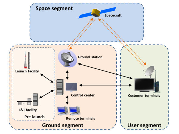
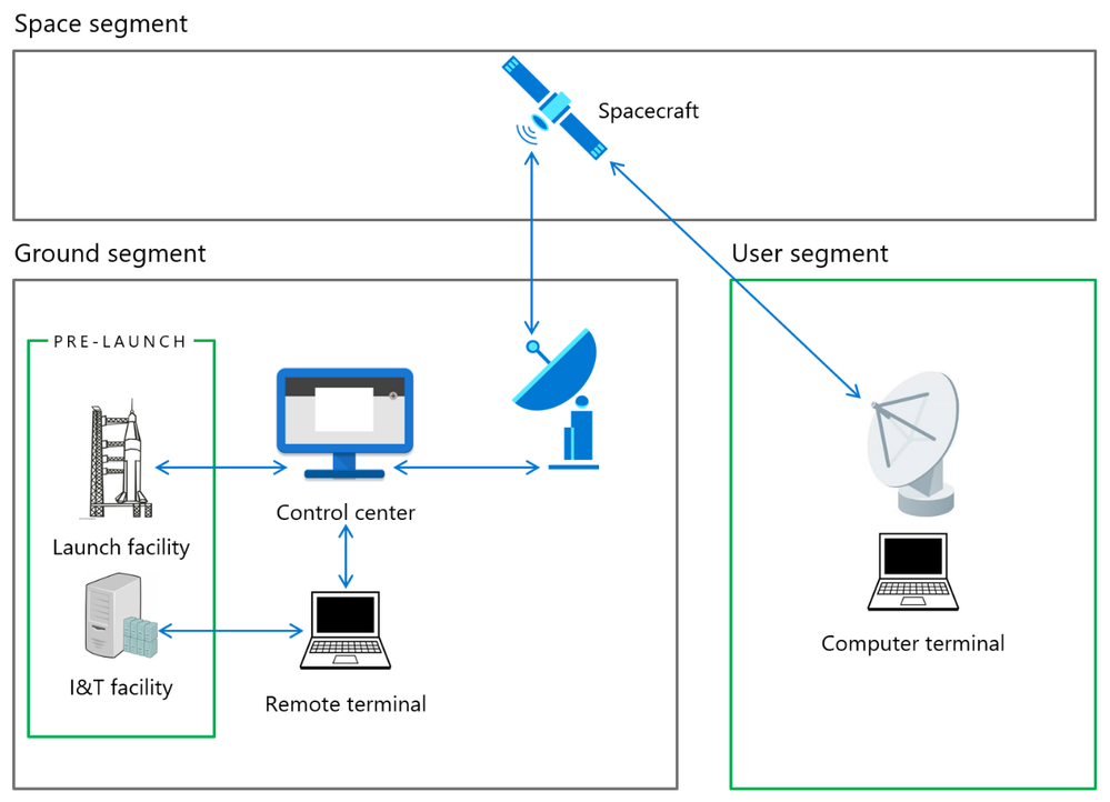
The space system—comprising the space segment, ground segment and user segment—is a trusted trio that together, brings space data down to Earth.
With the focus usually on building and launching a spacecraft into orbit, as well as the user segment when accessing and analyzing earth observation data, the ground segment is often overlooked. However, it is one of the most important elements of the space system. Being able to operate a satellite from the ground and download data back to Earth is vital to the success of an Earth observation mission.
As the number of satellites in orbit is predicted to grow exponentially, this growth needs to be paired with the growth of bandwidth within the ground segment sector. Otherwise, data collected by satellites in space runs the risk of not being transmitted down to Earth.
Let’s take a closer look at what ground stations are, the key role the ground segment plays and the future of downloading data from space.
What are ground stations?
Ground (or Earth) stations are terrestrial radio stations designed for extraplanetary telecommunication with spacecraft. They are a physical location that has an antenna allowing a satellite operator to down link imagery from their satellite after it’s been collected.
When a spacecraft is within a ground station’s line of sight, this period is known as the pass—when the spacecraft is above the local horizon and available for line-of-sight communication with a ground station.
The beginning of a pass is referred to as the acquisition of signal (AOS) and the end of a pass is the loss of signal (LOS). Each pass over a ground station is an opportunity to send data from and to the satellite. This satellite-to-ground link (SGL) describes the communication between a satellite and a ground station. If the ground station transmits a signal up to a satellite, this is an uplink signal. When a satellite transmits a signal down to a ground station, this is a downlink signal.

The International Space Station’s pass seen in the skies over Tampa, Florida on 18th May 2010.
Why are ground stations so important?
Ground stations are the way we remain connected to spacecraft.They are the first port of call for satellites beaming down data. Together, with the control center and remote terminals, the ground station forms the ground segment stage of the whole space system.
This ground segment enables us to communicate with and receive communication from satellites through uplinks and downlinks. Ground stations enable us to manage, monitor and control satellites from the ground as well as receive data collected in space.
It’s been continuously noted however, that despite the importance of ground stations, many satellite vendors—especially smaller vendors—plan this portion of their operations too late. We’ll get into the ways we can resolve this through the adoption of Big Tech solutions soon, but for now, let’s look at where we can find ground stations and how they work.
Where are ground stations positioned?
Ground stations can be located anywhere in the world, but there are some advantages to having them in specific locations. For example, if your satellites are in a sun-synchronous orbit, it’s a good idea to use ground stations that are close to the north or south poles. This allows you to have more passes in a day for your satellites and as a result, more downlinking opportunities.
Ground stations in general are either stationary or mobile in their position. They can be specialized, and used to communicate with satellites, space stations and uncrewed space probes.
The most common locations for ground stations are:
- Elevated areas – positioned on elevated terrain gives ground stations a better line of sight to the satellite. Whether on hills or mountains, this reduces the potential for signal blockage, weather interference and generally facilitates better communication.
- Remote locations – these areas have fewer physical objects that may impact signal transmission and greater visibility of the sky.
- Coastal locations – being by the coast is common in maritime and satellite applications for maritime communications as ground stations here offer excellent visibility of the horizon.
- Urban communications centers – high-tech centers or technology parks in urban or semi-urban areas provide robust and reliable infrastructure and power—essential to ground station communication with satellites.
Selecting ground stations
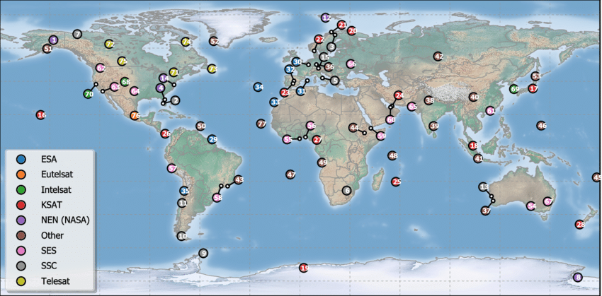
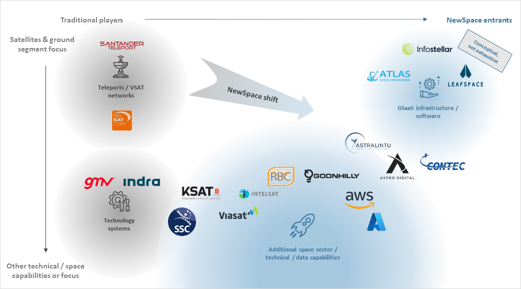
Most companies, when launching satellites, do not build their own ground stations. They partner with those who already offer large networks of ground stations across the world.
Players in the ground segment market include legacy technology companies, ground station and satellite operators (KSAT, SSC), NewSpace entrants such as (Leaf Space, Infostellar) and Big Tech companies looking to diversify their cloud offering (AWS, Microsoft Azure).
So, how do you select ground stations?
As mentioned earlier, it starts with the satellites. Each ground station varies according to the satellites with which the connection is to be established. Geostationary (GEO) satellites do not need a ground station with the same capabilities as a ground station tracking low-earth-orbit (LEO) satellites. That being said, they must all have the same starting point.
The factors to consider when selecting ground stations are:
- Antenna direction and alignment – it is very important that there is a configured alignment and tracking system that allows the link with the satellite to be as direct and accurate as possible in order to minimize losses.
- Frequency band selection – both transmit (TX) and receive (RX) frequencies must be present. In general, the most commonly used frequency band is ultra high frequency (UHF), very high frequency (VHF) and S band. Also X band, Ku and Ka band and optical comms see increasing use.
- Signal processing – digital signal processing (DSP) systems filter, modulate, demodulate, encode or decode information. Ground stations often receive weak or distorted signals, so ensuring these errors are detected and corrected is extremely important.
- Data throughput, storage and processing – having sufficient throughput, storage capacity and data processing capabilities is critical to extracting and analyzing useful information.
- Monitoring and remote control – the ground station will have software that allows it to communicate with satellites by sending commands and receiving telemetry in order to monitor both status and performance.
- Connection to terrestrial networks – whether via wired networks, microwave links or other communications technologies—connecting to the terrestrial network takes data from space and transmits it between locations across the planet.
- Safety and security – preventing security risks ensures the integrity of satellite operations and prevents interference. End-to-end data encryption, access control systems and lightning protection can all help to keep data safe and prevent misuse or compromise of the satellite.
How do ground stations work?
Satellite ground stations typically consist of advanced technology for receiving and analyzing signals. These include large parabolic antennas which are shaped like dishes to accurately reflect and capture incoming signals.
The antennas main purpose is to amplify the signal that’s incoming without affecting it by adding noise.
Transmitter and receive units are optimized to meet the specific requirements, depending on the type of ground station. Modems and terminal equipment are also part of ground stations to ensure efficient communication with satellites.
Getting to the ground
Data collected and stored in satellites only becomes useful to us back on Earth once we can receive it and take a look at what has been captured in orbit.
Typically, the maximum downlink volume of a ground station is determined by the link budget (communications hardware), energy budget (solar panel energy allocated to the comms system) and number of comms passes over the ground station (this depends on the ground station network).
For example, in one pass, Worldview-4, a high-resolution imaging satellite, downlinks up to 18 terabytes per day. This is achieved through a network of ground stations and a high-speed X-band data link (800 Mbps).
The stages
- Satellites in operation – first, satellites accumulate data and store it on board, awaiting the next ground station downlink opportunity.
- Data transmission – then, satellites communicate using radio waves to send signals to the antennas on ground stations. These antennas capture these signals during a satellite pass and process it.
- Processing and distribution – once satellites have transmitted data to an earth-based antenna, this data is stored in a data center. It’s important to note though, that there are a limited number of earth-based antennas, so time must be scheduled with them in advance.
Generally, transmission from satellites is done by either a high-gain or low-gain antenna. High gain antennas have to be pointed in exactly the right direction and can send a lot of data very quickly. This type of antenna is very precise. Low gain antennas don’t require such precise positioning, but transmit data much slower.
It’s usually best to use a high gain antenna, but a low gain antenna is often used after the initial launch and during the testing stages. It’s also a great backup in case the high gain antenna isn’t working or the satellite isn’t pointing in the correct position.
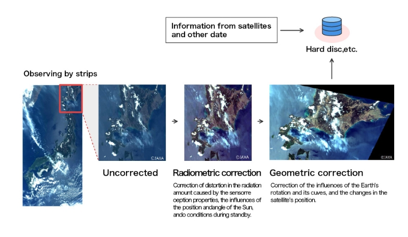
Processing and distributing data (Remote Sensing Technology Center of Japan).
Challenges and solutions
- Bandwidth issues – As demand for downlinking services increases supply, downlinking constraints such as bandwidth issues will impact the amount of data you are able to collect and use. Solutions such as building more ground stations, inter-satellite relay networks and optical communications as an alternative to radio frequency communications are all in development to tackle this.
- Frequency licensing – It’s important to register your frequency. The ITU oversees the allocation of the radio frequencies required to meet the continuously evolving needs of the satellite industry. The ITU also manages a cooperative satellite frequency registration process.
- Ground station accessibility – Finding a ground station provider to whom you can downlink your data can be challenging. As the request for EO data increases, so does the need to transmit large amounts of satellite data to ground stations.
- Orbit availability – Ground stations can communicate with satellites only when the satellite is in their visibility region. As mentioned, the timing and duration of passes depend on the type of orbit a satellite occupies, as well as the objects in space and earth. Satellites in geosynchronous orbit may be continuously visible, whereas those in low earth orbit only offer short-duration ground passes. In order to solve some of these challenges, a number of web-based and mobile applications predict passes for known satellites.
Next generation ground systems
As demand for data increases each day, ground stations and the satellites they search the skies for are evolving to become more efficient in their design and use. The next generation of EO satellites will need to be able to downlink an ever-increasing amount of data.
More efficient use of the frequency spectrum is needed for both S-band TT&C and X/K band data downlink operations. This will avoid the use of already congested banks, decrease the risk of interference from high latitude ground stations and improve payload data return.
AI in satellite data collection and processing
Leveraging AI capabilities is the present and future face of satellite data collection and processing. AI can be used to automate the collection of satellite data and reduce the amount of time spent by operators on data collection. Automating satellite data collection can reduce the likelihood of errors, improving the accuracy of the collected data.
AI also allows more data to be processed, sooner. Using neural networks and deep learning through computer vision models to interpret data drives efficient and informed decision-making.
Algorithms trained to detect objects, identify patterns and spot trends in large amounts of data are already having a significant impact on extracting value from satellite data. Faster processing times benefit applications such as weather forecasting, agricultural monitoring and natural disaster response.
Marketplaces like UP42 offer both geospatial data and processing algorithms. Their off-the-shelf processing algorithms enable a host of geospatial analytics from land cover classification to settlement mapping.
Ground stations as a service (GSaaS)
A new dawn for satellite ground stations is here with the emergence of ground stations as service (GSaaS) coupled with the API approach. The promising new method of satellite operations outsources ground infrastructure operations to a third-party provider. As a result, satellite operators can reduce costs, improve reliability and security while increasing flexibility.
By outsourcing the entire ground segment operating expenditure, satellite operators are better able to pivot to change technical requirements or the business model quickly, without worrying about owning ground assets.
The ground segment is increasingly experiencing disruption from companies offering GSaaS (space-tec).
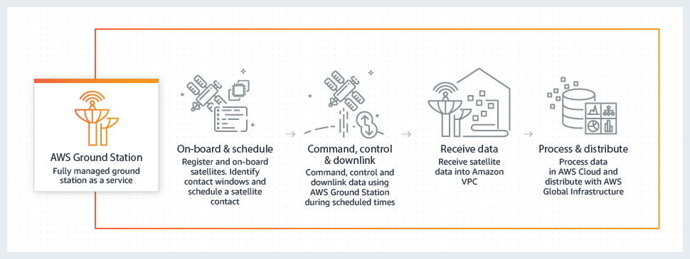
Big Tech companies not traditionally active in the space industry have also entered the ground segment space. Amazon Web Services (AWS) Ground Station is one of the most well known on the scene. Launched by Amazon in 2018, it provides a global network of ground stations in close proximity to the network of AWS infrastructure regions. As a fully managed service, AWS lets you control satellite communications, process data and scale your operations without worrying about having to build or manage your own ground station infrastructure.
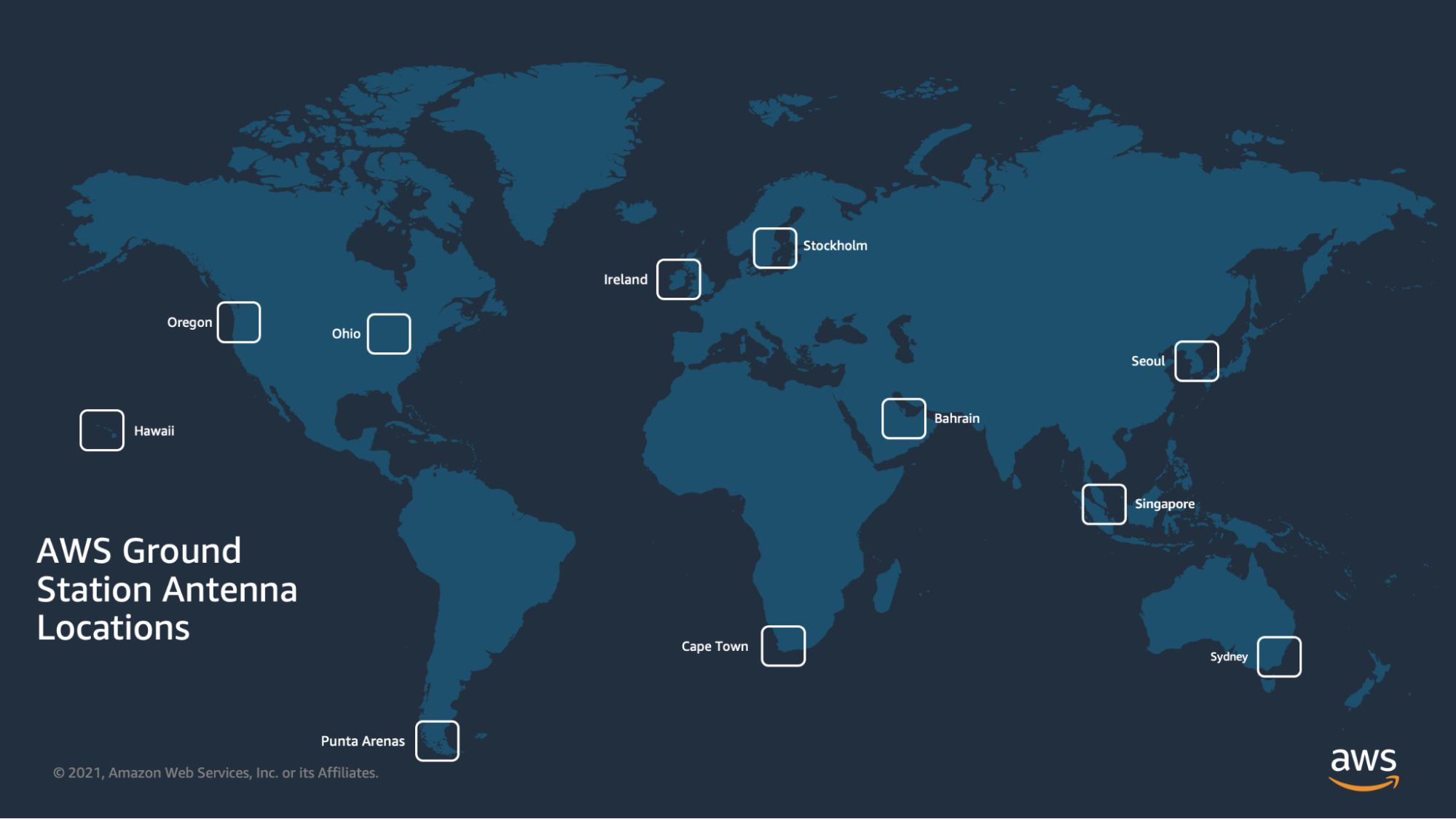
AWS has built a network of six ground stations located in the US (Oregan and Ohio), Middle East (Bahrain), Europe (Stockholm and Ireland), Asia Pacific (Sydney, Seoul and Singapore) and South America (Punta Arenas).
Microsoft has also entered the ground segment market with Azure Orbital Ground Station. The cloud-based ground station as a service allows satellite operators to receive their space data with near-zero latency over the Microsoft network. All you need to do is register a spacecraft, add it to your subscription and request authorization to use it. Each operator has their own contact profile resource which stores pass requirements such as links channels and network endpoint details.
While traditionally, ground station components are physical hardware, we can now virtualize hardware in a data center. Azure Orbital’s API simplifies operating various types of satellites across generations, allowing for seamless transitions of operations.
When a ground station is virtualized, APIs are developed which can be consumed in an app. For example, with Azure Orbital, the REST APIs can be used in a Mission Control app which can be stored in source control, updated through a pull request, integrated with continuous integration, and then deployed as part of a deployment pipeline.
KSAT has long been offering ground station services and solutions since 1968, with their ground network dotted across the globe. As part of Microsoft’s partner network, KSAT, alongside others, are enabling satellite operators to focus on their satellite and operate from the cloud.
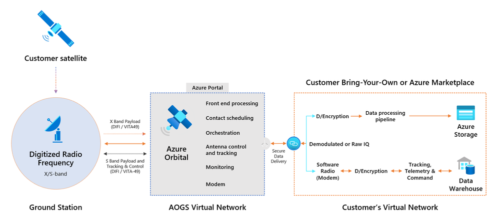
Azure Orbital Ground Station Architecture (Microsoft).
Conclusion
Launch vehicles and satellite spacecraft make a lot of the headlines but without the ground segment itself, they have little value. Satellite ground stations are built for collecting and streaming remote sensing data which is then provided to a variety of users and applications.
They enable downstream applications by downlinking data from satellites. As the world changes, it’s more important now than ever to keep up with the pace of change. Ground station and satellite technologies are evolving side by side as AI streamlines data collection and processing. Organizations such as UP42 offer access to the world’s leading providers of optical, radar, elevation, and aerial data, alongside advanced analytics, all in one place.
Ground stations as a service is said to be the future as satellite operators can rent a ground station to communicate with a satellite, rather than build their own. This frees satellite operators to focus on the mission, revealing new insights and understanding sooner. NewSpace innovations are bringing fresh new ways of working to the entire space value chain. As the number of satellites increases, as does the sector of ground segment providers.
Now, the industry is evolving as demand for GSaaS emerges and pricing models such as by-the-minute or per-pass open up access to new players on the market.
So, where does this new and improved ground segment offering leave the future of the market? New business models are disrupting the status quo and soon, innovation across the industry will be necessary for companies to remain relevant and keep up with the pace of technological innovation.
Did you like this article? Read more and subscribe to our monthly newsletter!

#Categories

Next article
Bridging the Gap: How Buying Satellite and Drone Data is Evolving
Editor’s note: This article was written as part of EO Hub – a journalistic collaboration between UP42 and Geoawesomeness. Created for policymakers, decision-makers, geospatial experts and enthusiasts alike, EO Hub is a key resource for anyone trying to understand how Earth observation is transforming our world. Read more about EO Hub here.
Those working with Earth observation data have always been presented with two options: the detailed precision of drones or the expansive reach of satellite imagery. Since most projects face some form of constraints, whether in the form of budget limitations or the logistical challenges of sourcing data from multiple providers, many have had to settle for one type of data over the other. This can affect their scope and potential—satellite data may not provide sufficient detail, while drones might not be practical for the scale of the project.
However, the industry is currently undergoing a significant shift, and these challenges are being addressed head-on. Accessing comprehensive geospatial data is about to become more streamlined—and more accessible—than ever before.
A Comparison of Satellite and Drone Data
Before considering how their procurement differs, it’s worth remembering what sets these two powerful data sources apart in terms of their qualities and applications.
Satellite data provides a continuous, broad overview of the Earth’s surface, which is advantageous for large-scale and long-term monitoring projects like vegetation mapping and environmental management. The resolution of satellite imagery varies: Open-source data may be around 10 meters per pixel, while premium services can offer resolution down to 30 centimeters per pixel—but at a higher cost, ranging on average from $20 to $30 per square kilometer for tasked data. Satellites’ ability to operate is unimpeded by weather conditions—although the quality of images can be affected by cloud cover. Satellites also offer the valuable ability to analyze historical data, or monitor an area of interest long-term, through frequent revisits.
In contrast, drone data offers higher resolution images, sometimes down to less than 1 centimeter per pixel. This allows more precise and detailed analysis of specific areas, making drones ideal as an engineering tool. Drones can also be deployed rapidly, and provide greater control over data collection—ideal for time-sensitive applications. In contrast to satellites, drones are not affected by cloud cover; however, it may not be possible to operate them in adverse weather conditions or in some jurisdictions. They are often cost-effective for small, targeted missions, but will prove far costlier for expansive projects.
As can be seen, each technology is uniquely suited to different aspects of geospatial analysis, and the decision to use drone or satellite data will typically depend on the project’s scope, the detail required, and available budget. However, by combining both data sources, truly comprehensive insights can be achieved: for instance, in disaster response, satellite imagery can pinpoint areas of concern, and drone imagery can then be deployed to aid rescue missions. In construction, satellites can assist with project oversight while drones can provide engineering measurements. In environmental management, satellites can track changes over time, whereas drones can assess specific surface features or polluting infrastructure. This dual approach is key in enabling targeted and efficient interventions on the ground.
Acquiring the data
Buying both satellite and drone data has traditionally been a complex process, but recent advancements have streamlined these transactions significantly.
Buying Satellite Data:
In the past, satellite data could only be purchased directly from satellite operators—an at-times arduous process. However, it has now become more accessible through various platforms.
- Marketplaces like UP42 have simplified the purchasing process, offering a user-friendly interface and immediate access to a diverse range of satellite data, including historical data for time-series analysis or recent imagery for up-to-date monitoring. One of the most significant advantages of using a marketplace is that they aggregate multiple data sources, rather than being limited to a single satellite constellation. This variety can be crucial, as any one provider may not meet all the requirements of a project.
Buying Drone Data:
When it comes to drone data, the options have been to either operate drones in-house or to purchase the data from service providers.
- In-house drone operations can be cost-effective for those who use drone data at scale, but it requires a high degree of engineering knowledge and skill, and will also involve significant initial investment in hardware and/or software. Costs include purchasing a drone and obtaining relevant pilot licenses, while learning to use photogrammetry processing software will require both time and money. Additionally, securing flight authorization from local air navigation service providers is likely to be essential.
- Service providers, on the other hand, provide a turnkey solution for businesses needing precise, area-specific insights without the overhead of managing drone operations. Typically, these companies don’t just provide their own drones, but also handle every aspect of the project, from flight planning and authorization to data capture and processing. It’s a practical option for companies that need specialized drone data but do not have the infrastructure or expertise to collect it themselves. There is now also an increasing number of companies offering tailored drone mapping, surveying and inspection services, reflecting a growing demand for high-resolution geospatial data.
- Marketplaces for drone data now also present a powerful new option for those seeking drone data. Globhe, for instance, is a platform which crowdsources drone data from around 10,000 independent drone operators. It allows for drone ‘tasking’ from any area of interest, as well as providing a huge 70TB database of imagery at a fraction of the cost of custom data.
Integrating Drone and Satellite Data Acquisition
Whilst purchasing both types of data previously involved navigating multiple providers, the industry has recently made another leap forward in terms of convenience and efficiency due to a partnership between UP42 and Globhe. Globhe’s vast selection of drone data and tasking capabilities are now available directly through UP42’s marketplace, creating a game-changing new option for customers who require both types of data, and ensuring consistent, high-quality geospatial information is readily available for any area of interest.
The single marketplace model not only saves time, but also opens the door to new geospatial applications—it’s likely to be especially useful for projects that span multiple locations worldwide, including in developing countries where contracting reliable drone services can be a challenge.
The Democratization of Earth Observation Continues
The integration of drone and satellite data procurement is another significant stride toward democratizing Earth observation. A simplified process, through initiatives like the UP42-Globhe partnership, makes geospatial data more accessible to a wider range of projects and sectors, including those with lower budgets. This in turn paves the way for smaller, more agile projects, potentially presenting innovative new solutions for sustainability, development, and more.
As the marketplace continues to evolve, we can expect to see an upsurge in creative and impactful applications of geospatial data across various fields, making a substantial contribution to our understanding and management of the planet.
Did you like this article? Subscribe to our monthly newsletter!