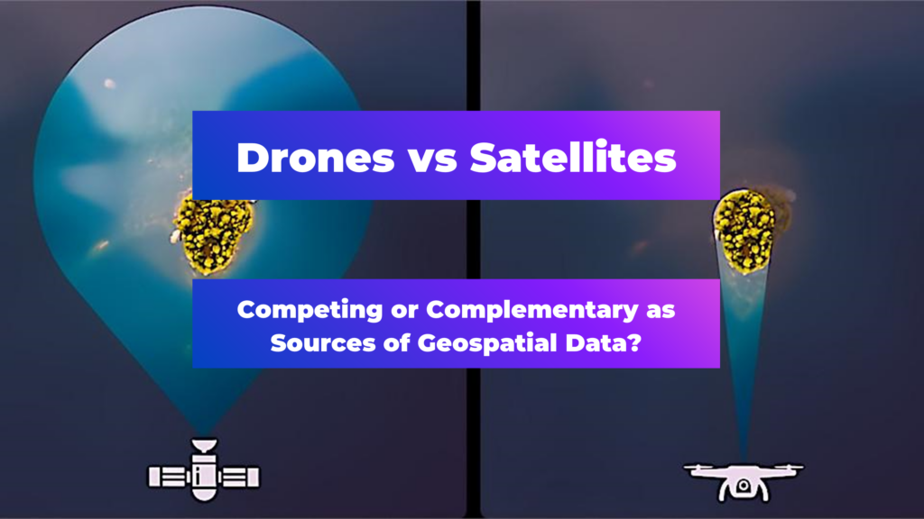
Are Drones and Satellites Competing or Complementary as Sources of Geospatial Data?

Editor’s note: This article was written as part of EO Hub – a journalistic collaboration between UP42 and Geoawesomeness. Created for policymakers, decision-makers, geospatial experts and enthusiasts alike, EO Hub is a key resource for anyone trying to understand how Earth observation is transforming our world. Read more about EO Hub here.
Both drones and satellites have helped to usher in a new era in Earth observation. These two remote sensing tools have revolutionized our ability to gather detailed data about our planet’s surface. While they might seem like rivals at first glance, a closer look reveals that their strengths are in fact complementary, with each making up for the other’s weaknesses.
Drones are recognized for their ability to capture detailed, high-resolution images of relatively small areas, with unparalleled agility and precision. However, their range, coverage and flight time are inherently limited, often restricted by their battery life and susceptibility to adverse weather conditions. Here, satellite data can be a powerful ally, with the ability to capture vast swathes of the Earth’s surface quickly, efficiently and repeatedly.
There are numerous instances where data from drones and satellites can be utilised in tandem to give a more comprehensive picture of the Earth’s surface.
Comparing Drones and Satellites Data Sources:
Looking deeper into the specific attributes of satellite and drone data, it becomes apparent that each source offers unique benefits. When used together, the two tools provide a synergistic approach to Earth Observation. This table provides a comparison of their qualities:
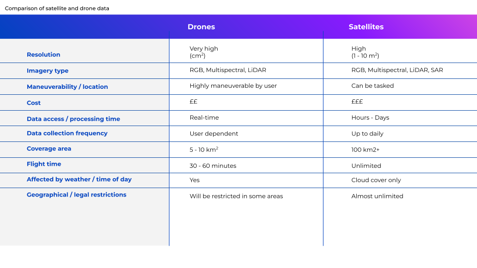
The key benefit of drones is arguably their ability to provide very-high spatial resolution data, down to a centimeter level—in other words, incredibly detailed imagery. This is ideal for engineering tasks or safety assessments, for example. By contrast, while the spatial resolution provided by satellites is improving all the time, it is still significantly lower than that captured by drones, typically ranging from meters to tens of meters. Where satellites really excel, however, is in their ability to provide a macro perspective, capturing data over vast areas quickly and efficiently. Datasets on this scale are invaluable for comprehensive analysis and decision-making, and management of large-scale projects.
Another advantage of drones is that they can be deployed incredibly rapidly and are highly maneuverable—critical for time-sensitive or targeted missions, such as searching for survivors in the immediate aftermath of a disaster. The immediacy with which drone data can be accessed and analyzed is also of huge importance. However, a drone’s flight time is often restricted by limited battery life. Satellites are not such a flexible and highly targeted option, but they offer constant and consistent monitoring. They are also able to make frequent revisits to a given area of interest, offering regularly updated data—ideal for long-term monitoring.
One of the biggest drawbacks of drones is that they can be limited by weather conditions like high winds. Their use may also be restricted in certain locations due to local legislation or logistical challenges. Satellites, however, can observe any place on earth, and capture data in all conditions—even at night, if using Synthetic Aperture Radar (SAR) systems. It is worth pointing out, however, that in heavy cloud cover, satellites are not able to capture spectral data, unlike drones, which can fly below the clouds.
Finally, although cheaper options are becoming available, satellite data can still be quite expensive. This means that drones are often the most affordable solution for localized or short-term operations. On the other hand, for large-scale projects, economies of scale mean that satellite data very often proves to be more cost-effective.
In short, the wide areas of coverage and frequent revisits achieved by satellites provide data on a scale not possible for drones, while drones provide an ideal solution for many of the shortcomings of satellites. Furthermore, satellite imagery, with its macro perspective, can contextualize the detailed data provided by drones. When combined, they deliver a rich, robust data set, invaluable for a wide range of applications.
Acquiring the Data:
When it comes to drone data, there are a few operational models that cater to various project needs. For instance, individual users may own and operate their drones, which gives immediate availability and full control over the data collection process. It can also be the most affordable option for simple or small-scale projects. However, operating drones requires a certain amount of expertise depending on project complexity and size, and for a variety of reasons direct ownership may be impractical. Therefore, drone operations are sometimes subcontracted—either to specialized companies that provide the drone equipment and pilots, or by purchasing data from platforms like Globhe, which crowdsource data from professional drone operators.
Satellite data, on the other hand, has traditionally been prohibitively expensive for many use cases, and purchasing it directly from satellite companies has been a challenge to say the least. However, data marketplaces like UP42 are democratizing the use of satellite data, making it increasingly easy for users to purchase discreet data sets, or even task satellites themselves, and to integrate this data into their workflows.
Interestingly, the recent partnership between UP42 and Globhe is a prime example of how the landscape is still changing. This collaboration brings Globhe’s world-leading collection of drone imagery to UP42’s well-established geospatial marketplace, and enables users to order drone data from any area of interest around the world in much the same way as they procure satellite data. Being able to access both types of data from one source has the potential to radically streamline the process of data acquisition and analysis. The development is significant for a number of industries, including agriculture, environmental conservation, and disaster response, where the combination of drone and satellite data can lead to more informed decisions and effective interventions.
Use Cases for Drones and Satellites Working in Tandem
Disaster response is a key application for Earth Observation. In the immediate aftermath of a disaster, drones are rapidly deployed to assess damage, providing vital data to aid rescue operations and damage assessment. Satellites, meanwhile, offer a wider perspective, mapping the affected area and tracking the progress of recovery efforts over time. This combination ensures that every phase of the disaster response—from immediate relief to long-term rebuilding and prevention—is informed by the best possible data.
Similarly, in the field of flood monitoring, drones can be deployed to capture high-resolution imagery of the affected areas—images which show the extent of the damage and can be instrumental in planning immediate response actions. Satellites further complement this by monitoring the extent of the flooding over a wider area, and tracking its movement over time, offering a strategic view that’s essential for recovery and future planning.
Another compelling use case is in agriculture—particularly in crop monitoring. Both drones and satellites can be equipped with multispectral imaging cameras to assess the health of crops. However, while drones can assess crops at a granular level, identifying areas of stress or disease sometimes on individual plants, satellites can monitor the growth and yield of crops over an entire farming region. This dual approach ensures both targeted intervention and overarching management of agricultural resources.
Complementary Tools for Comprehensive Understanding
Drones and satellites are not competitors when it comes to Earth Observation. Instead, with their unique capabilities, they are complementary tools. When used together, they provide a more comprehensive and accurate understanding of the Earth’s surface, which can prove crucial for a variety of applications. As an increasing number of industries continue to leverage these technologies, we can look forward to a future in which our planet is observed with unprecedented precision and insight.
Did you like the article? Read more and subscribe to our monthly newsletter!

#Categories

Next article
What Construction KPIs Can Be Measured Using Satellite and Drone Data?
Part 3 in our EO Hub construction series
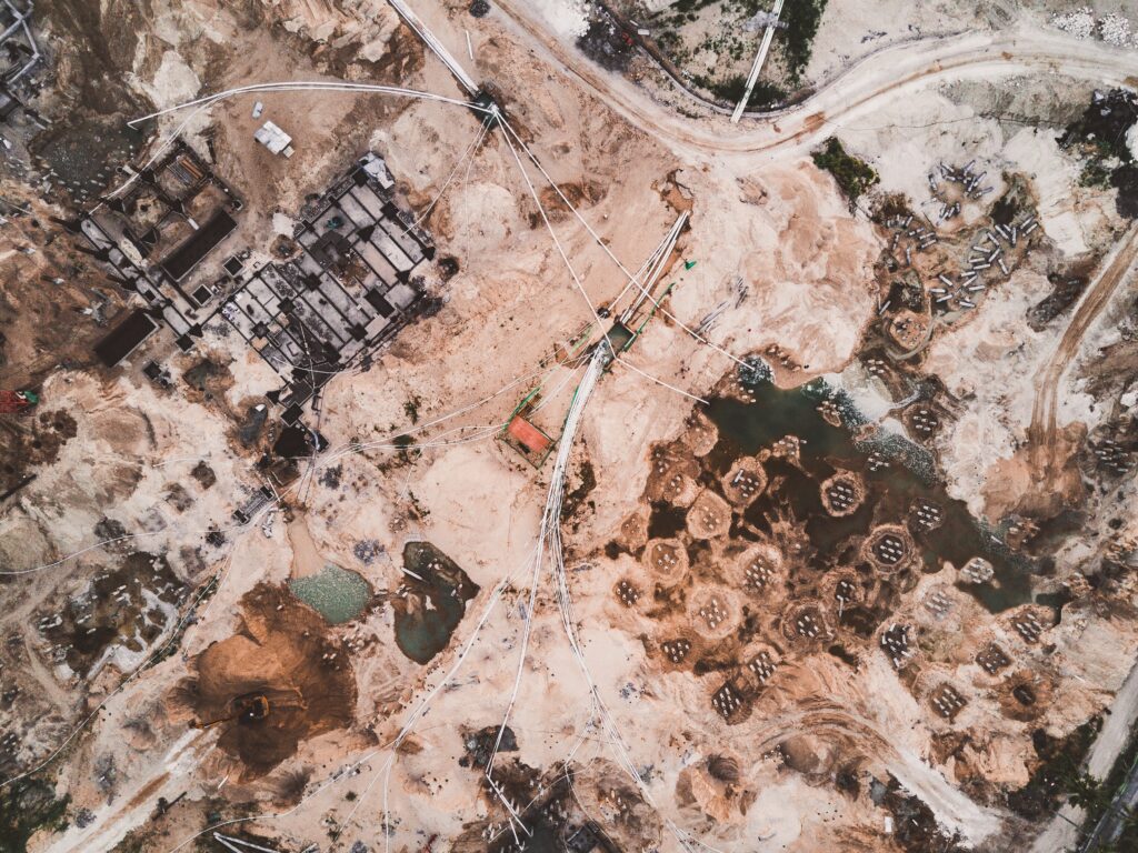
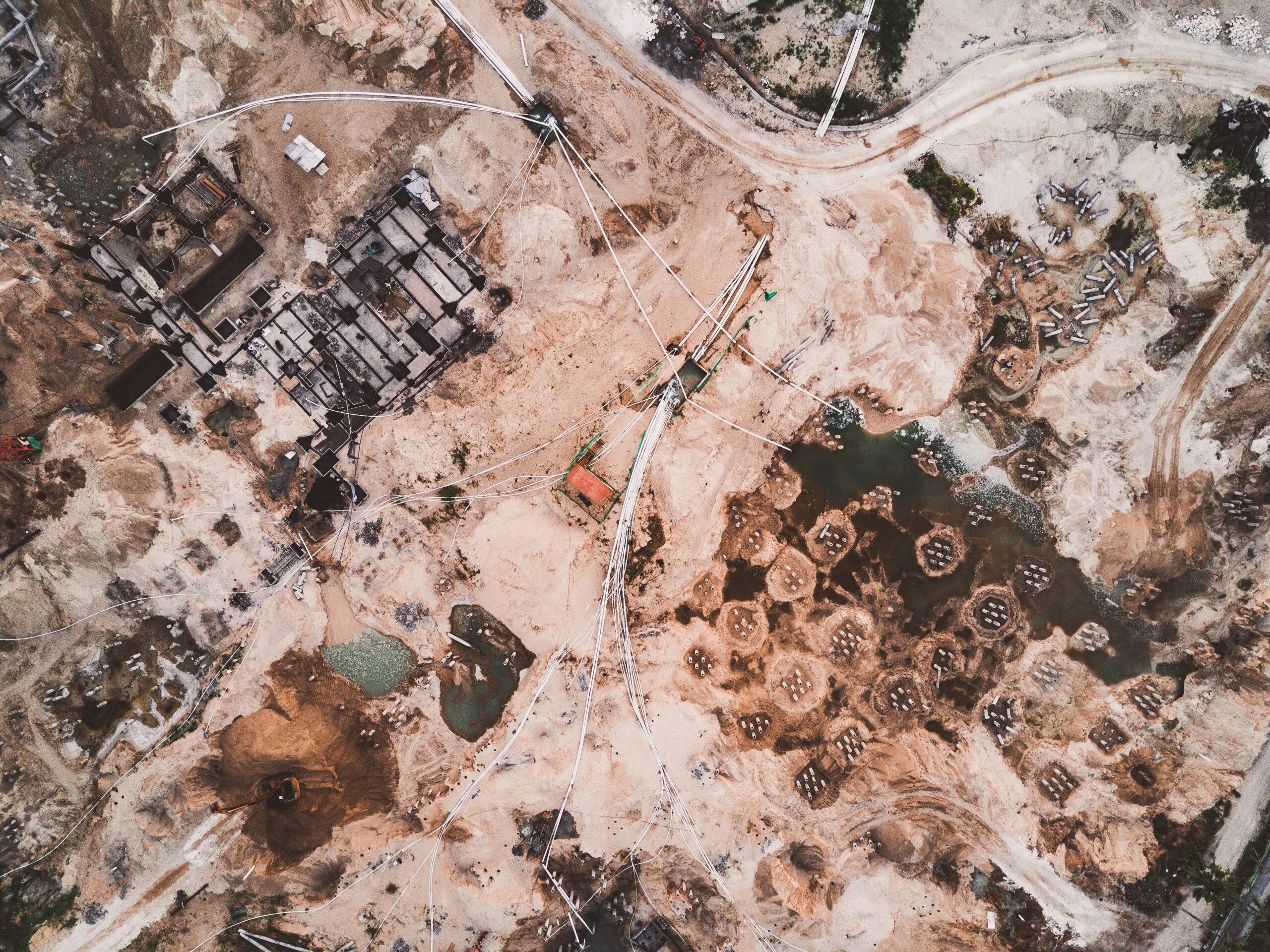
In the evolving landscape of the construction industry, drones have already proven invaluable, and satellite technologies look set to join them, especially for large-scale and mega-projects. Used in tandem, these tools have the potential to transform the sector, capturing precision details, providing a high-level view of project progression, and ushering in a new era of data-driven decision making.
We’ve previously explored the different roles of satellite and drone data in construction progress monitoring and the value satellite data can add for different stakeholders. In the third and final article in our series, we explore the specific roles each of these technologies can play in measuring vital key performance indicators (KPIs), and precisely what KPIs they are able to capture.
Construction KPIs: Key functions of Earth Observation
For construction mega projects, different stakeholders will naturally be interested in different sets of KPIs. While general contractors, construction companies, designers, inspectors and land surveyors will be interested in engineering analysis of every centimeter of the construction, investors and owners will be interested in a more high-level view of the site—very challenging over the vast expanse of a mega project.
In this context, drones and satellites carve out separate but complementary niches in the construction industry, each offering unique insights. Furthermore, these tools are most effective when used in combination with traditional methods, such as in-person land surveying. Used as part of a holistic approach to construction monitoring, Earth Observation tools have the potential to support many different aspects of a project:
Schedule Adherence: One of the hallmarks of a successful project is its ability to stick to timelines. Both drones and satellites can help to monitor the rate of on-site completion. Satellite data will be used to detect high level adherence to work schedule, such as whether the mobilization of resources, equipment, and machinery is going according to plan, or whether the construction of particular structures are on time. Drone data will allow stakeholders to go a little deeper, looking at specific steps for each structure—if the footing is ready, reinforcement installed, support pillars in place, etc.
Budget Management: Both technologies aid in cost control by tracking resource allocation; for example, monitoring the volume of materials being used at different project phases, and by spotting any discrepancies that may hint at possible issues with wastage or theft. Drones are already a standard tool used for volumetric measurements of construction earthworks, proving much more accurate than traditional methods. Satellite data products such as Elevation 0.5 from Airbus allow measurement of 50cm volumes; this may not be accurate enough to provide detailed measurements, but it can give a high-level overview of resources on site.
Quality Control: In terms of quality control, detailed drone imagery is ideal for spotting minute structural inconsistencies or deviations from design specifications. Optical and LiDAR sensor–equipped drones provide absolute accuracy down to the level of several centimeters, which cannot fully substitute traditional high-precision methods, but is more than enough for many engineering KPIs. Satellite imagery, on the other hand, is often the only tool which can detect any changes over the broader area (e.g. surface deformation or environmental factors) which might compromise the project’s quality.
Safety Compliance: On a construction site, safety is paramount. Here, drones can be tasked to spot specific safety lapses, such as improper material storage, the absence of safety gear, or unsafe working conditions. Satellites can measure large-scale hazards such as pooling water, potential landslides, or emissions.
Environmental Impact: Satellites are the best tool for monitoring environmental KPIs. They are unsurpassed when it comes to measuring broad changes in local ecosystems, such as alterations in local vegetation patterns or bodies of water, or even changing wildlife activity. All these factors provide insights into a project’s environmental impact. Satellites are also able to track a mega project’s alignment with any environmental standards and regulations.
Stakeholder Communication: Regular visual updates are invaluable for stakeholder engagement. Here, drone-captured imagery provides detailed insights into the project’s evolution and information about specific structures, while comprehensive satellite images provide a full view over the whole mega-project site, allowing stakeholders to follow the project’s progression in its entirety.
Productivity Metrics: Specific KPIs and units of measurement
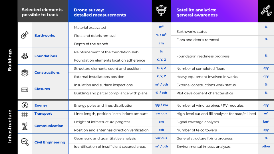
Having touched on the overarching roles of drones and satellites, it’s worth digging deeper into some specific KPIs and their units of measurement to help understand the contribution of drones and satellites when it comes to tracking progress. Drones are primarily an engineering tool, while satellites function as a management tool, and the specific KPIs reflect this. However, both tools can play a role in gauging productivity by capturing specific measurements for accuracy and consistency, with drones quantifying on-the-ground activity like worker numbers or equipment use, and satellites assessing the overall pace and scale of the project.
For instance, when monitoring earthworks, drones can capture trench depths to a centimeter level, and calculate the volume of excavated material in cubic meters. Satellites, on the other hand, provide a high-level overview of factors that affect the whole project, like the amount of vegetation displaced or percentage of earthworks completed. While foundations are being laid, drones are able to verify the placement of elements using specific geographic coordinates. Satellites offer a broader view, measuring foundation readiness, and a high-level view whether concrete has been poured or not.
During construction, drones track the exact positioning of structural elements, while satellites can, for example, detect the presence of heavy machinery by count, indicating the scale of work in progress, and can measure the percent of completed structures. In the closures phase, drones may focus on issues like insulation and surface inspections, while satellites capture a macro view of external construction work progress, marking high-level milestones as they’re achieved.
Of course, different types of construction projects will require different types of KPIs to be measured. For instance, in infrastructure projects, drones measure specific details, such as the distribution of power lines or the height of structures in centimeters. Satellites count larger features, like the total number of turbines or pylons, and can provide high-level volume measurements, like cut-and-fill analysis in cubic meters. Within civil engineering, drones deliver detailed and quantitative geometric analyses, whereas satellites offer high-level insights assessments of construction progress and broader environmental impact assessments.
Earth observation in construction: a suite of tools for complete and holistic project oversight
Drones and satellites have undeniable potential to revolutionize the way we approach construction, particularly in large-scale projects. These technologies, when coupled with advanced analytics, offer an unparalleled depth of insight, allowing for meticulous tracking and improvement of vital construction metrics and KPIs. This holistic overview, combined with granular detail, grants managers an extraordinary level of control and oversight.
Throughout this series—describing the different roles of satellite and drone data in progress monitoring, showcasing their immense value for various stakeholders, and laying out their functions when it comes to KPIs—it’s hopefully become clear that the use of these technologies drives efficiency, refines quality, and significantly augments the chances of a project’s success.
As we conclude the series, we hope that the construction industry is ready to embrace these advancements, not just to keep mega-projects on track in terms of efficiencies, but to propel the entire sector into a more precise, informed, responsible and sustainable future.
Did you like the article? Read more and subscribe to our monthly newsletter!