
Can you imagine any better way of story telling than using a map? Hard to image. This was the thought of designers at German Salt Museum (former salt mine since the Middle Age) in Lüneburg, a city close to Hamburg, Germany. They’ve created amazing interactive installation, entitled „Salt Worldwide“ which tells the story of the salt mining around the world and
The map presents a virtual world made of salt with 34 touch sensitive salt crystals spreading over the map. When touched the crystals start to glow and some of them launches extra virtual information. Moreover each crystal launches a millions of salt particles that flow over the world map, slide down along the mountain ridges, and along the currents in the seas. It gives an amazing impression. I love it.
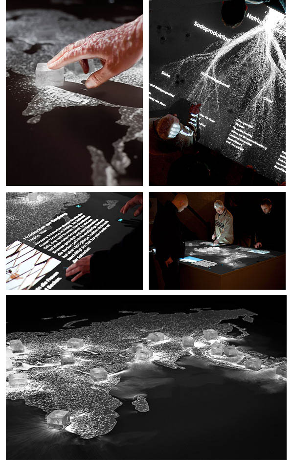
source: ArtCom

#Ideas


Next article

Aston University
What will OpenStreetMap (OSM) look like in 2018? Will it beat Google Maps in popularity or will it just grow into a larger community as more people will start using OSM for their own benefit? In short: what will the future bring OSM? These and other questions were part of debate during the international congress State of the Map 2013, which was held at the Aston University in Birmingham (UK) at the beginning of September. More than 300 members of the OSM community gathered together for their yearly held congress and shared their experiences with OSM.
OSM is what we call a collaborative project to create a free editable map of the world. Maybe you haven’t heard of it yet, but there are over a million mappers – as OSM users call themselves – worldwide. And this community is still growing larger day by day. It was created in England in 2004 by computer engineer Steve Coast. Coast didn’t like the large sums of money government-run and tax-funded organization asked for using their maps. Since then the OSM community grew to over a million users, all volunteers, who collect data using GPS devices, aerial photography, and other free sources. These crowd sourced data are then made available under the Open Database License. More than 20 million kilometer of motor ways, bicycle paths and walking paths have been mapped.
International
Everybody is free to participate in this community. Map data is usually collected using a GPS unit, although this is not strictly necessary if an area has already been traced from satellite images. More and more companies discover the advantages of this detailed open source data. For example, the White House used OSM for president Obama’s change campaign. Also Wikipedia, Flickr, Foursquare and Apple are using OSM for several purposes.
The OSM maps are almost real time updated and improved. This is also one of the major advantages over Google Maps where for example each change must be approved by a so-called “reviewer” and is wholly owned by Google. Or where data supplied by the mapmaker can later be removed.
More apps needed
But why is OSM less known by a larger audience than for example Google Maps? It is not a PR problem, experts say. It is actually the famous chicken and egg story. The more companies and administrations use OSM and invest in OSM, the more people will get to know the advantages of this free open data and because of that the more companies will use OSM in new applications. But if everyone works with Google Maps, few companies will be interested to develop applications for OSM maps.
 The so called Future Group of the OpenStreetMap Foundation also struggles with these dilemmas. Its members want to see OSM in a broader perspective: Where will it be in five years? What will we as a community have achieved by then and what is needed to get there?
Simon Poole, chairman of the OSM Foundation: ‘We do not provide services such as Google, but free to use data instead. We must therefore ensure that we become more visible. We can do that by creating a good balance between the people that capture the data – the mapmakers – and the organizations using the maps for a variety of applications. As more and more organizations use OSM maps and also let people know they do so, the use of OSM and interest in this open source data will surely increase. OSM needs companies like Mapbox to deliver a complete product.’
More open data
Mapbox was one of the sponsors of the State of the Map congress 2013. No wonder, as CEO Eric Gundersen is a strong supporter of open data. ‘The freer the data, the more you can do with it, the more you can innovate, the more the user will benefit. The fact that we now use global navigation systems in our cars, is only because we can use free GPS data that was created by the United States Army. Data that was released because the U.S. government decided to make all data freely available which was government funded.’ An initiative that very soon will be followed in all EU countries, as the law changes in 2015 and government data will be opened up. A great result of the open data initiative by European Commissioner Neelie Kroes from the Netherlands.
 Gundersen predicts a growth of OSM use in the future. ‘It’s not a PR problem, it’s a tool problem. As soon as more tools come available to OSM, the number of users will grow by itself. Just look at the fact that now we have acquired VK, the second largest social network in Europe, at once 195 million new users get acquainted with OSM. VK is particularly active in countries like Russia and Belarus. If all those people use these maps and complete information, we automatically get better detailed maps from those areas. The community of OSM should in our opinion mainly keep doing what they are doing now: producing good maps. And companies like Mapbox provide the services around it.’
Humanitarian aid
Also Kate Chapman, board member of the OSM Foundation, is convinced of the usefulness and necessity of OSM. Chapman is executive director of HOT, the Humanitarian OpenStreetMap Team, that bridges the gap between traditional humanitarian aid and OSM. HOT was founded shortly before the Haiti earthquake. The organization could immediately show how important it is to help the community and infrastructure fast and free with an accurately well detailed map of the disaster area. The same happened later in the areas that were devastated by the tsunami.
Chapman: ‘We talk within the OSM community not just about technology, but also about the possibilities of open source data. So far we have mainly focused on Europe and North America, where most of our users live. Now we also focus on areas where users need us most. Next year our conference State of the Map will be held in one of these countries. This also gives an immediate problem: OSM is mainly working with volunteers. That delivers beautiful results, but isn’t always practical. Not anyone can take time off from work to attend a conference. We could have paid staff for strategic issues, but that in turn requires fundraising and we don’t want to be too dependent for money on one single party. I also think we should focus on other languages. English, German and French are the main languages within OSM. More languages should be supported. Then it becomes easier for people to use OSM in their own environment.’
Innovation
 Stefan Keller, professor of Information Systems at the Hochschule für Technik (HSR) in Rapperswil, Switzerland, is using gamification to interest a whole new group of users in OSM. Gamification uses game elements to motivate users to work on a project and thus gain experience that way. ‘Two of my students figured out how you can reach enthusiastic new groups and also how one can ensure that mappers that are no longer active become active again. The game [www.kort.ch] indeed attracts new users.’ According to Keller gamification is just one of the many roads that OSM can take to attain more popularity and growth amongst a wider audience. ‘More importantly: what does the OSM Community want to attain in five years time? Do they only want to make maps that support their open database or do they want to make a map that can also be used for other purposes?’
Skobbler CTO Philipp Kandall (Germany) and member of the OSM Community hopes for the latter: ‘I certainly hope OSM will become the predominant map as Wikipedia has become the predominant encyclopedia. I believe open maps are a very important goal, and therefore my hope is that OSM can go beyond a display map and be used more and more by everybody from automotive companies to everyone else. In 2018 OSM will – as I hope – be the default map on many huge portals and apps such as Facebook, Apple Maps and TripAdvisor and become a significant and major competitor for Google Maps. The community should have reached 1 billion+ people who use apps/sites with OSM data and 10 million editors, with at least 10.000 of them being actively mapping every day. Then we most likely will be leaders in the mapping space all over the world.’ Or as Mikel Maron (former member of the board of the OSM Foundation) puts it: ‘I can’t imagine a future without it.’