The perfect storm called artificial intelligence and geospatial big data

On April 20, 2010, when BP’s deep-water drilling rig Deepwater Horizon exploded in the Gulf of Mexico, the oil giant claimed that the spill was just 1,000 barrels per day. A small non-profit in West Virginia, SkyTruth, studied the satellite observations of the oil slick, cataloged its computations, and concluded that the spill was at least 20 times bigger than what was being claimed. The report was quickly picked up by the media, and lead the US government to straightaway increase the estimate to 5,000 barrels of oil per day.
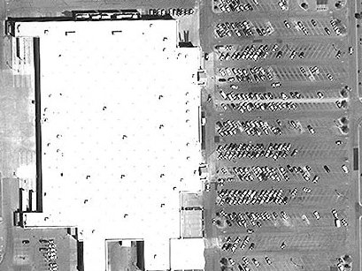
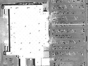 The same year, UBS Investment Research had two teams quietly working on Wal-Mart’s quarterly earnings preview – one using time-honored traditional methods, the other studying the satellite pictures of the American retail brand’s parking lots to gauge the customer footfall. Each came up with a different revenue forecast. No prizes for guessing which team’s projections were more accurate.
When these analytical use cases for commercial satellite imagery made headlines, the space economy had only begun to detangle itself from the clutches of governmental monopoly. Today, plummeting launch costs and the deluge of small and affordable satellites have guaranteed that we have many more eyes in the skies – revisiting different parts of the earth at a much greater frequency, and taking our cache of high-definition EO imagery beyond the scope of human analysts.
Thankfully, this invasion of big data has been accompanied by an equally vigorous advancement in data analysis techniques (like classification and prediction) which have been the driving force behind geographic information systems (GIS). Technologies like artificial intelligence, deep learning and machine learning have matured just in time to equip us with the tools we need to make sense of an ever-increasing trove of imagery data. (Read: What’s the difference between Artificial Intelligence, Machine Learning and Deep Learning?)
So, when Facebook wants to find out the exact geographical locations where people do not have access to the Internet, all it needs to do is take 350 TB of satellite imagery and run it through an AI-enhanced image-recognition engine. After processing 14.6 billion pictures, the company can identify more than 2 billion disconnected people across 20 countries.
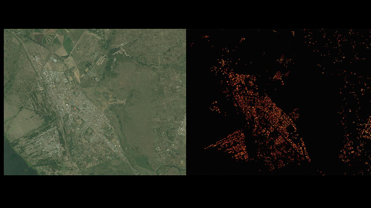
Satellite imagery of Naivasha, Kenya (left) and Facebook’s analysis of the same (right)
Researchers at Stanford University adopt a similar approach while making predictions on poverty. They ask a machine learning system to compare daytime and nighttime satellite imagery and see which areas are devoid of artificial lights – a tell-tale sign of lack of affluence.
The same technology enables Global Fishing Watch’s tracking platform to comb through 22 million location logs provided by ocean vessels every day and determine what kind of fishing gear is being used by what kind of ship – allowing citizens, governments and researchers across the planet to access data about commercial fishing activity in a manner that simply didn’t exist earlier.
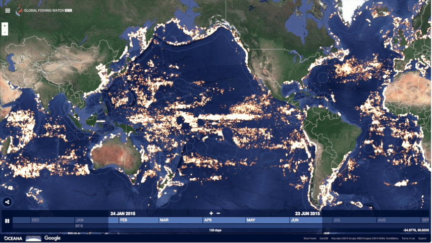
Global Fishing Watch
Among the things that didn’t exist earlier also fall geospatial data refineries. Today, we have highly-specialized startups whose only job is to dig through the wealth of imagery data captured by companies like Airbus, DigitalGlobe, and Planet, and extract extraordinary insights from them.
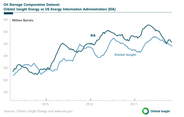
Take Orbital Insight for example. This geo-analytics startup is working to help stabilize the price of oil by giving investors an unprecedented look into the volume stored by countries whose public data cannot be readily trusted. At the end of 2014, by analyzing high-res sat imagery for aboveground oil storage, Orbital Insight was able to identify 2,100 petroleum reserve tanks in China – four times more oil than what was being reported by the industry’s standard database.
In another project, the company sifted through daytime satellite imagery for the World Bank, zeroing down on geospatial features like buildings in developed areas, car density, and agricultural land. These features would go on to serve as useful indicators of economic activity and poverty at the local level and help the World Bank determine where it should focus its efforts more.
Another geo-analytics startup, Descartes Labs, is looking at tons of pixels generated by satellites to predict food yields months in advance of current standards. The company collects data from every single farm in the United States on a daily basis and uses spectral information to measure chlorophyll levels in crops. In essence, Descartes Labs is working to help alleviate a food crisis even before it happens!
SpaceKnow, meanwhile, is monitoring over 6,000 industrial facilities across China by comparing satellite imagery and assigning values for optical changes like visible inventory or a new building. This allows the startup to make independent predictions about China’s economy in its China Satellite Manufacturing Index, which even went live on Bloomberg Terminal last year.
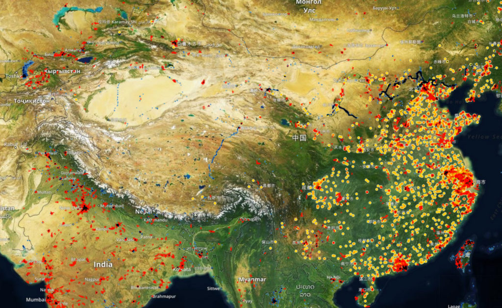
SpaceKnow is monitoring over 6,000 industrial facilities across China
These are only a few instances where the coalescing of remotely-sensed data with computer vision, machine learning, and artificial intelligence has aided investments funds, Fortune 500 companies, humanitarian organizations, et al, to observe global socio-economic trends – and keep an eye on the planet as if it were a living entity – at the speed of business.
As the analytics metamorphoses from conjectures to precision, the implications for multi-billion industries can be pretty incredible. And geospatial companies are only beginning to explore the tip of this big data analytics iceberg.

#Business


Next article

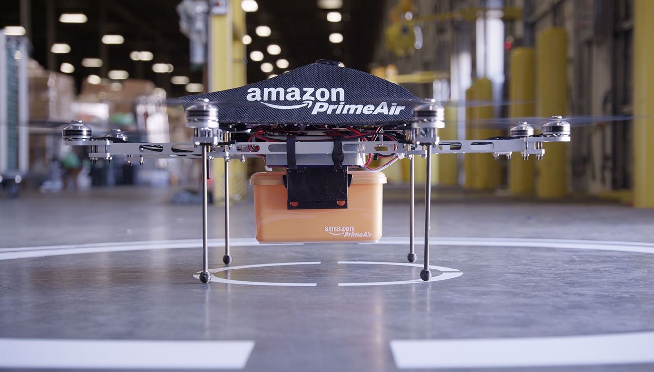
Four years ago, in December 2013, Amazon Founder and CEO Jeff Bezos shared with the world his vision of using flying robots to deliver products. “I know this looks like science fiction. It’s not,” he assured of the service called Amazon Prime Air, even as critics hollered that the announcement was nothing more than a marketing gimmick aimed at grabbing the attention of Christmas shoppers.
Four years later, not only has that seemingly crazy concept of drone delivery glided squarely inside the realm of plausibility, it has almost become an obsession with tech bigwigs. Getting these delivery drones off the ground, however, was a process riddled with regulatory hiccups and operational complexities.
Taking off
To begin with, the Federal Aviation Administration (FAA) of the United States spent much of 2014 treating Amazon like its ex, completely ignoring the latter’s request to test its drone delivery services. The legislative cold-shoulder was frustrating enough for Bezos to look for options in other countries. So, Amazon set up an R&D center in the United Kingdom, where it concluded its first successful drone delivery to a Cambridge home in 2016. Its first public demo in the US didn’t come until this March.
Meanwhile, Google’s Project Wing completed its first public drone deliveries at an FAA-sanctioned test site of Virginia Tech in 2016, delivering lunch orders to hungry students and employees. The tech giant also started collaborating with the FAA and NASA for setting up an air traffic control system for drones.
This week, a team at Project Wing joined hands with a Mexican food chain and a pharmacy brand to test the delivery system with customers in rural Australia. “The information we gather from both of these test partners will help us build a system so that merchants of all kinds can focus on what they’re good at — like making food or helping people feel healthier — rather than being distracted by complex delivery logistics,” said James Ryan Burgess, co-lead of Project Wing.
The US Postal Service (USPS) scrambled to join the race, but only after conducting a nationwide survey in mid-2016 to get a sense of the American public’s rapidly-evolving perception of this new mode of delivery. The USPS study revealed that more Americans liked the concept of drone delivery (44%) than those who disliked it (34%), but almost one-fifth were yet to make up their mind.
That ambiguity, however, didn’t stop the national mail service of Switzerland, Swiss Post, from joining forces with US-based drone logistics company Matternet to leverage the option of faster deliveries for the healthcare industry. In March this year, Swiss Post successfully completed 70 flights where drones transported laboratory samples autonomously between two hospitals. The service is now weaning off the test phase and in the process of being formally launched, keeping company to Iceland’s on-demand drone delivery service by online retailer AHA.
But if you keep fields like healthcare and disaster recovery aside, do the numbers from drone deliveries actually add up? How much sense does it make for Amazon and other companies to use drones for commercial deliveries?
The economics
If a recent study by Skylark Drone Research is to be believed, “The economics of using commercial UAS for package delivery are so compelling, companies in the package delivery market will either need to adopt this new disruptive technology or face declining market power in the face of a new industry model.”
With more than 100 million products being sold online on a daily basis, and almost 90% coming in the weight range that a drone can deliver economically, the report found that an online retailer could save $0.76 per delivery. This basically means that the annual savings for a large logistics company like Amazon could range anywhere between $2 billion (pessimistic forecast) and $10 billion (midrange forecast) at the least.
Courtesy: Ark Invest
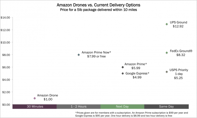
Earlier, a report by Ark Invest had detailed how if the FAA gives Amazon clearance for the commercial rollout of its drone delivery service – which promises to deliver the product within 30 minutes of a customer placing the order – the price that a consumer would pay for the delivery of a five pound package could come out to be as low as $1.2. That’s almost 8-13 times less than what companies like Federal Express and United Parcel Service would charge for much-longer delivery time, the report explained.
Opening up
All this, as well as much more open approach of other countries toward drone deliveries, must have made sense to someone in the White House. Because only last month, the US President Donald Trump passed an executive order designed to accelerate the approval of drone flights over crowded places and for longer distances.
“To promote continued technological innovation and to ensure the global leadership of the United States in this emerging industry, the regulatory framework for UAS operations must be sufficiently flexible to keep pace with the advancement of UAS technology,” the memo read, allowing local governments to seek FAA waivers for currently prohibited activities like testing drone deliveries in urban spaces and UAS traffic management systems.
Expectedly, this initiative should help to dissolve the tensions between federal regulators and the commercial industry – and encourage Amazon and Project Wing to test their drone delivery services in the United States. So, if a burrito delivered by a drone is what your heart desires, now is the time to keep the faith!