
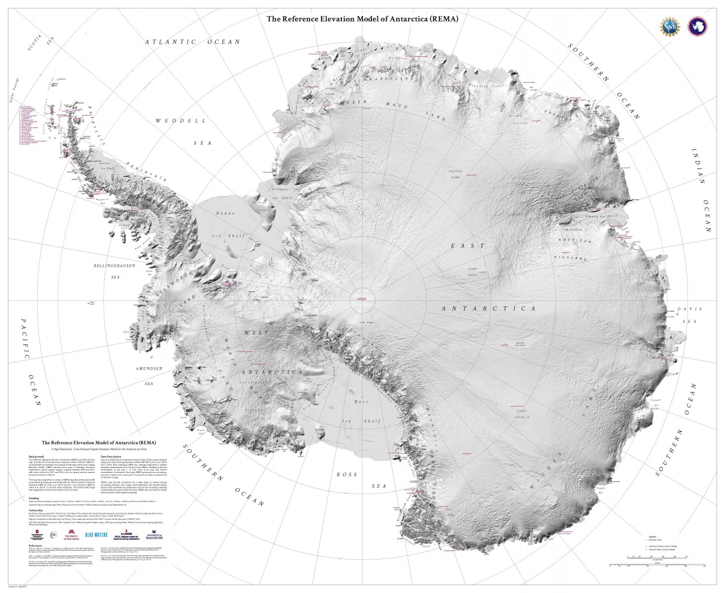
Did you know: Up until September 2018, we had a more detailed map of Mars than we had of Antarctica? That, thankfully, has been changed by scientists in the United States who have released a new map of Antarctica – one that puts maps of all other continents to shame.
This new map, called The Reference Elevation Model of Antarctica (REMA), has a resolution of 2 to 8 meters, compared to the previous maps’ spatial resolution of 1,000 meters. Seeing them side by side in the image below helps to appreciate the stark difference in visual clarity of the two maps:
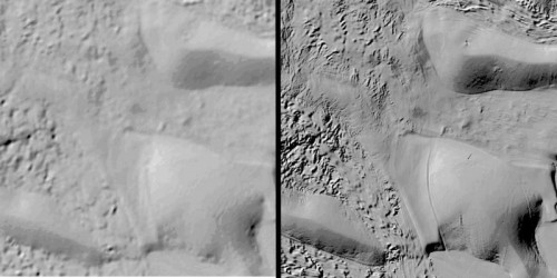
Comparison between prior available surface imaging (left) and REMA (right) shows dramatically improved detail. Courtesy: OSU
According to project leader Ian Howat, who is a professor at The Ohio State University, “At this resolution, you can see almost everything. We can actually see variations in the snow in some places. We will be able to measure changes in the surface of the continent over time. We will see changes in snow cover, changes in the motion of ice, we will be able to monitor river discharge, flooding and volcanoes. We will be able to see the thinning of glaciers.”
If you’re thinking that sounds a bit too incredible, wait till you hear what the file size of this one single map is: 150 terabytes! Check out its miniature version below:
No wonder it took a supercomputer to process the high-resolution images provided by a constellation of polar-orbiting satellites. On an average, these satellites captured all the different regions of Antarctica at least 10 times – resulting in a map so accurate that you could even do route-planning for the treacherous terrain of the continent, just like you would have done for any urban city using Google Maps.
As Howat sums up, “It changes the threshold of what you can do in the comfort of your own office compared to what you had to do in the field.”

#Ideas


Next article

The market for drones (professional and private) is growing steadily. According to a forecast by Gartner, the total market will be around $11.2 billion by 2020 (market forecast report).
A large part of this will be distributed among commercially-used drones in a wide variety of application areas. Especially when flying in large areas, fixed-wing drones have a technical advantage, as they are more durable and efficient than conventional multi-copters. One company that strives to dominate the fixed-wing drone market is the Munich-based startup, Quantum-Systems.
I strongly believe that our latest drone – Trinity is unbeaten in large-scale surveying and mapping applications(claims CEO Florian Seibel). Trinity has a flight time of 60 minutes and is perfectly suited for carrying sensors such as RGB and/or multispectral cameras. The fully automatic and electrical driven UAV combines the best of both worlds – multicopter and fixed-wing drones. The Trinity is probably the most efficient Vertical Take-off and Landing (VTOL) fixed-wing drone on the market today. Oh, and did we mention the open source payload compartment on Trinity? It certainly is one of the most adaptable UAVs out there in the market.
“With the Trinity, we aimed for a product that meets the requirements of professionals. Therefore we started from scratch with a highly integrated industrial product in mind, “ says CEO Florian Seibel. “You can see the result in every detail, whether it is the optimized electric layout, the efficient payload compartment or the clean finish of the outer shell; the Trinity showcases the best of German engineering. The entire Trinity design process was designed to combine maximum efficiency with maximum versatility. ”
All system-critical components such as the autopilot or the mission control software have been developed in-house in order not to be dependent on any third party in any area and to achieve maximum results. An additional benefit is the fact that the entire operation of the Trinity works without cloud connection to the Internet, which is an important aspect for public authorities in particular.
The ideal solution for a wide range of applications
Thanks to the automatic and VTOL capabilities of the Trinity, this unique drone opens a wide variety of totally new applications. The system is used in many ways: Agricultural, forestry, wildlife protection, mining, inspection to name but a few examples. Especially for aerial surveillance, the drone can convict with super-efficient maneuvers and very high reliability.
The flight capability alone is not enough, the data is important
The recorded data is compatible to any kind of post-processing softwares, such as Pix4D or AgiSoft, which provide precise calculation and enable users to interpret high-resolution aerial data. The Quantum-Systems Trinity is definitely worth a look for rookies and experts in the drone survey industry.
Probably this is the reason why the Trinity is used in very different types of applications, like vegetation screening of railroad tracks in Germany, survey of winter sports resorts in Europe(link to the video) or plant monitoring in Indonesia.
Making it easy for users and adding value to results from the use of drones are certainly the main tasks for drone manufacturers, as well as service providers. A product like the Trinity can certainly make a contribution here to positively influence market growth, as Gartner predicts.
The key features include:
VTOL-fixed wing system
Combining VTOL and fixed wing capabilities into an easy-to-use system gives the user the freedom of choice for his mission requirements.
Easy and safe handling
A push of a button is enough and the Trinity will do its assigned job. The control unit has a clean layout without confusing switches and levers. This ensures easy handling even in manual controlled situations.
Longest flight time in its class
Being designed to switch to a glider powered by one rotor enables the Trinity to benefit directly from an enhanced long range capability. The wing geometry is optimized to push the maximum flight time to at least 60 minutes with a total payload of 0.5 kg. while the total weight of the UAV stays under 5 kg. Based on these key data, it is possible to cover up to 1200 acres in one flight with the Trinity!
Superior sensor and data results
The sensor compartment is shock-protected and the SD-cards are easily accessible from the outside. The sensors are powered by the Trinity’s battery and an accurate geotagging is achieved by measuring the exact trigger point via power consumption. The combination of hard- and software guarantees perfect results with a maximum of accuracy.
References:
If you would like to read a bit more in detail about the different use cases where Trinity and Quantum Systems were involved –
- Environmental hazard studies in Chernobyl
- Inspection of industrial pipelines in Sumatra
- City planning in Jakarta
- Mining in Garzweiler, Germany
- 3D reconstruction in Norway(link to the video)
- Road inspection and construction in Germany
This article was sponsored by Quantum-Systems
“Quantum-Systems is based in Munich, Germany. In 2017 the Bavarian company attracted a lot of attention in the international drone market when it released the Trinity, a commercial drone with a maximum take-off weight of less than 5 kg. “