
On September 11, 2001 the world had changed. 19 terrorists from al-Qaeda, hijacked
four commercial airplanes, deliberately crashing two of the planes into the World Trade Center towers and a third plane into the Pentagon in Arlington, Va. The Twin Towers
ultimately collapsed because of the damage sustained from the impacts and the
resulting fires. After learning about the other attacks, passengers on the fourth
hijacked plane, Flight 93, fought back, and the plane was crashed into an empty field in western Pennsylvania about 20 minutes by air from Washington, DC. The attacks killed nearly 3,000 people from 93 nations. 2,753 people were killed in New
York, 184 people were killed at the Pentagon and 40 people were killed on Flight 93.
Cleanup of the Ground Zero site took nearly a year. The rebuild process took another 14 years. We’ve decided to check how the history of World Trade Centre site looks like from the sky. The first available satellite images of the site come from 1994 and 1997 where you can still see The Twin Towers. Next image dates back to September 11, 2001 just after the towers collapsed. Than we can see the long process of rebuilding the site with the last image dating September 2015.
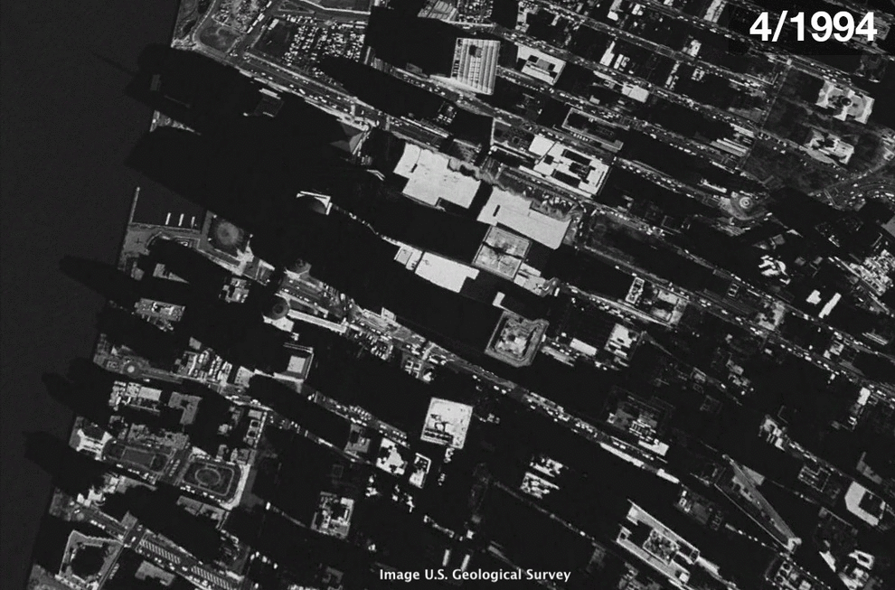
Satellite-based visualization: Rebuilding NY after 9/11
The world should never forget about this tragedy!
How this satellite-based visualization was created? All the images are screenshots from Google Earth.
Did you like this post? Read more and subscribe to our monthly newsletter!

#

Next article

A few years ago when startups like Planet Labs (now Planet), Skybox Imaging (now Terra Bella) started their ambitious efforts to monitor the planet with satellite swarms, the possibility of having a “satellite based search engine” for the world seemed too futuristic to be true. Sure, the potential of such a data-driven tool seemed enormous and the possibilities, limitless but the logistics of launching a (private) constellation of satellites to monitor the world seemed a bit ahead of its time. Fast forward to today and we have Planet, Terra Bella and Digital Globe all gearing up for the Geospatial Big Data revolution.
Earlier this week, Planet and Orbital Insight announced a new partnership, taking advantage of each others capabilities to address the needs of the financial markets.
Planet & Orbital Insight – Helping Hedge Funds with Satellite Imagery and Machine Learning
Orbital Insight, the World Economic Forum’s 2016 Technology Pioneer, wants to track the economic pulse of the world using satellite imagery on a daily/weekly basis and Planet has terabytes of data from their dove satellites orbiting the world every day. The partnership is of great interest to the financial markets that is ever hungry for more data driven analytics to give them a leg up over the competition.
“Our priority is to find high impact trends that can’t be quickly and reliably measured with traditional tools. Waxing and waning shadows on floating oil tanks reveal oil supply from space, cars in store parking lots indicate peak business hours and prefered stores, new construction indicates a prospering economy, shrinking surface water is a sign of instability. These changes, sent to the right people in near real-time, have the potential to affect thousands of decisions every day.” – Orbital Insight, Medium
Economic Development in Nanning, China over 7 months between December 2015 and May 2016. Image Copyright Planet
The future is already here!
“This partnership represents some of the most exciting trends happening in the geo world. And the reason is simple: Five years ago, a partnership like this wouldn’t have been possible because the capabilities didn’t exist. Datasets like Planet’s (broad coverage, high frequency monitoring from nano satellite constellations) were the domain of academic papers, and machine learning driven geo-analytics just weren’t happening in commercial markets. We have come an awfully long way.” – Josh Alban, Planet
Read more: Tiny Satellites: The Latest Innovation Hedge Funds Are Using to Get a Leg Up
Did you like this post about initiative of Planet & Orbital Insight? Read more and subscribe to our monthly newsletter!