
Google I/O had some very interesting location keynotes and some big announcements about Project Tango. One of the interesting keynotes that we didn’t get to watch live – “Making Android sensors and location work for you” had an interesting update for the GPS measurements and the GNSS researchers and the industry as a whole.
Google is making raw GPS measurements available to developers!
“This is groundbreaking. It is the first time in history that a mobile application will have access to the raw GPS measurements. This is beneficial to many, but especially the phone makers, because they can use these measurements to help them in their performance testing.” – Steve Malkos, Technical Manager, Android Location and Context Team
Okay, so what?
Google’s move to provide access to raw GPS measurements isn’t necessarily exciting news for Android users; the biggest benefit will be increased location accuracy (and hopefully) lesser time to get that increased accuracy but for the developers and researchers this is great news.
Smartphones as earthquake sensor?
Remember the research (from 2015) where the scientists were working on using smartphones as earthquake early warning sensors? One of the limitations in the research was that they needed to provide external GPS sensors in order to get the raw GPS/GNSS measurements required to be able to serve its purpose as earthquake early sensor. With Android N, they will be able to reach a much larger audience and all without having to provide external sensors.
What’s in it for the industry?
The high-precision location industry isn’t going to benefit from having access to raw GPS measurements on your smartphone where the GPS sensor isn’t build for such high-accuracy applications. However, it’s going to be really interesting to see how the industry uses these low-cost, low-accuracy sensors for in-car navigation and other applications where near meter-level accuracy is required.
“….And if you ever had a bright idea on how to use GPS measurements, now’s your time to shine.” – Steve Malkos, Technical Manager, Android Location and Context Team
Did you like this post? Read more and subscribe to our monthly newsletter!


#


Next article
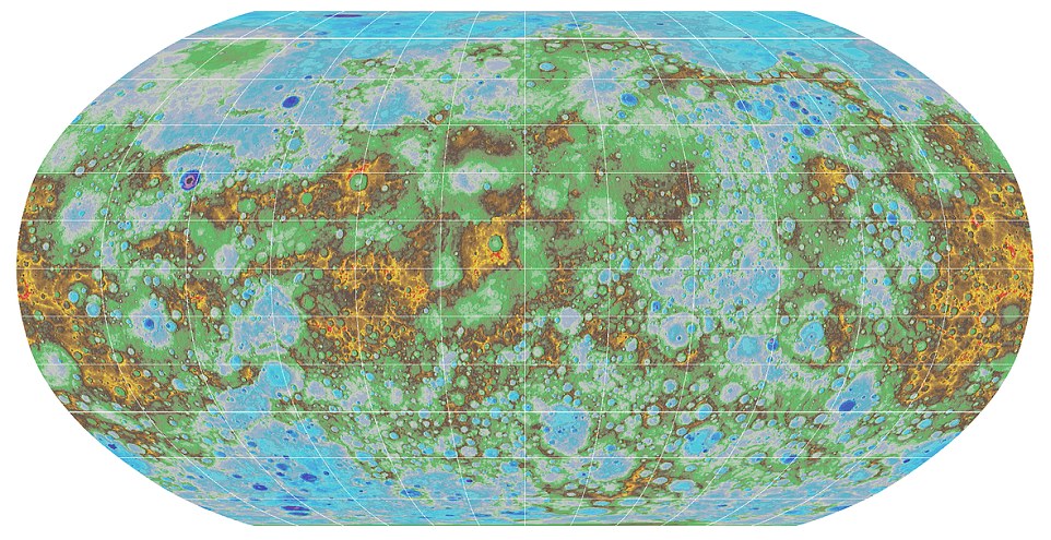
Mercury, the closest planet to our sun, now has an accurate topographic map. But how do you make a map of the whole planet which is 48 million miles (77 million km) away?
The scientists used 100.000 images taken by NASA’s MESSENGER. The spacecraft (which is an acronym for MErcury Surface, Space Environment, GEochemistry and Ranging) launched toward Mercury in 2004 and began orbiting the planet in 2011. Last year it ended its four-year long mission after flying around Mercury 4100 times. It took several months to process the data and place on a graticule (a network of longitude and latitude lines on a map).
The effect of their work is a high-resolution topographic map that the view of the planet’s entire surface. It shows craters, volcanoes and tectonic landforms among oth. The blues and greens show a lower elevations, while warmer colours show the planet’s volcanoes and mountains.
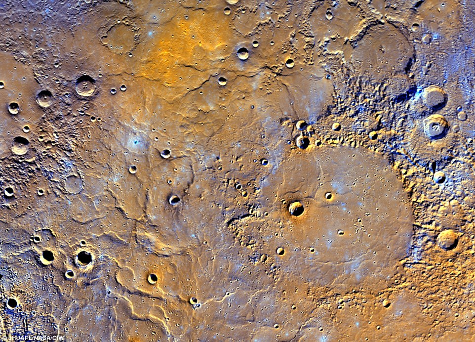 Mercury’s lowest point lies in the Rachmaninoff basin, located in the northern hemisphere, and is about 3.34 miles (5.38 km) below the planet’s average elevation. The highest peak on the planet, meanwhile, is located just south of the equator, and is 2.78 miles (4.48km) high.
The map was a collaboration between then U.S. Geological Survey, Arizona State University, Carnegie Institute of Washington, Johns Hopkins University Applied Physics Laboratory and Nasa, and it’s truly amazing.
Did you like this post? Read more and subscribe to our monthly newsletter!