
Geographers, Cartographers, Geospatial engineers, GIS professionals are usually the kind of people we would refer to as Geogeeks! But then, as location data and spatial analysis become mainstream, more and more people with a different (and colourful) background are contributing to spatial sciences and map making with their unique perspective. The quintessential offbeat Geogeeks. Hence the new series (yup, it’s a new year thing) OffBeat Geogeeks!
It’s really inspiring to know that people from non-geo background are just as crazy about maps as we are! One of the recent projects that really amazed me was the Line Of Sight project, where the designer visualised satellite trajectory data in a really interesting manner. The project was featured on several magazines and even people from NASA tweeted about it 😉
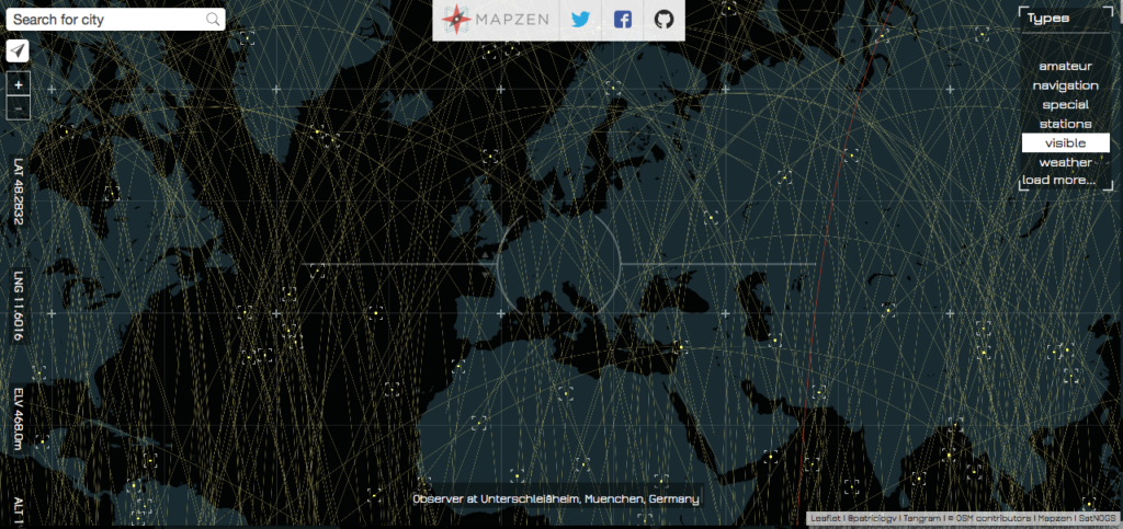
Line Of SIght by Patricio Gonzalez Vivo
I had a blast talking to Patricio, the guy behind the Line of Sight project (Scroll to the bottom for more about Patricio). Patricio is currently working at Mapzen as a graphic engineer. Here’s what he had to say to Geoawesomeness.
How life at Mapzen? Do you consider yourself as a GeoGeek now that you work with a “mapping lab”?
I don’t have a geo-background. Luckily, here in Mapzen, most of the people have very uncommon backgrounds. I remember my job interview with Randy (our CEO) & Brett (our CTO) and how interested they were in my art background. I thought how cool it was that Mapzen was really interested out of the box perspective to make a mapping lab. For me is the equivalent of working in the original Bell labs, where we have lot of freedom to push the boundaries of mapping.
Line of sight is an amazing project. What was it that attracted your attention to tracking and visualizing satellites?
I have been interested on the subject of landscape for a while. One of the things that most seduce me about it is the scale and complexity of it, to the point that our perception need assistance to really perceive what’s really going out out there. That’s where technology becomes a prosthetic medium of perception.
Recently I become interested on radio frequencies, this “old” and omnipresent technology is invisible to our sense but influence almost every aspect of our life. Radio waves is an essential part of our modern life, we use it constantly but never in a direct way. I was excited to discover that most satellites can be seen with naked eyes at nights, and also is not to hard to communicate with them. So I decide to make a tool that helps discover if a satellite is on the line of sight and how I could listen or talk to it.
Obviously you had to write more than a few lines of code to get the Line of Sight map but one very mystical aspect was the animation 😉 Could you tell us more about the magic behind the scenes.
As an artist, it was very important the experience of finding this invisible objects. That’s where the idea of smoothly moving satellites become important. But there was a technical limitation I need to solve in order to smoothly display the accurate position of over 2000 satellites. For solving these I use Mapzen’s powerful and flexible 2D & 3D map engine, call Tangram. Tangram is a webGL engine designed to combine vector tiles with GLSL shaders (one of my favorite languages). The trick is based on the old-school computer graphic technique of encoding data on an image. Values (in this case coordinates) are transform into colors using the RGB channels. Satellites future positions are precompute, translated to colors and finally incorporated to a big image. These image is then loaded to the graphic card, which have parallel processing power, and can nicely animate and draw satellites for a given moment on time.
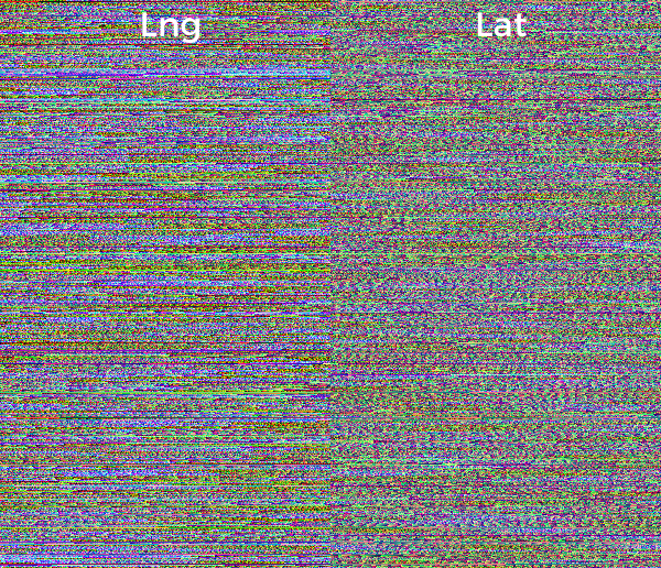
Line of Sight texture from Github
The poetic twist of this technique is that ironically the concept of “hided” information on color is not new for astronomers. As you know stellar spectra, use the color spectrum of the light coming from a star to determine the composition of it.
Talking about programming, you mentioned that you are a self-taught programmer (P.S: he has a degree in clinical psychology). What was the motivation behind the move and where did you start?
I always like to figurate out how things work. I guess my past life as a clinical psychologist, was motivated by trying to understand us. I like to experiment a lot, so as a therapist I start learning new techniques, like expressive art therapy, which finally introduced me to arts. I discover a community of brilliant and generous artist in the field of new media. They were making different frameworks to do art with computers. I got hooked immediately! I teach my self how to code using Processing and openFrameworks. Both libraries, are easy to learn and have huge communities around them. I start with Daniel Shiffman’s Learning Processing orange book, then I spend a lot of time on OpenFrameworks Forum, learning C++. I believe I have had millions of teachers for different part of the world that barely knows they have been important in my career. That’s why I have a big appreciation of openSource initiatives.
The community plays an important role in Open Source. Is that what makes you work on Open Source projects?
Definitely YES! I’m very lucky to be part of Mapzen. We are all-in for open source. I enjoy working on the open. I believe deeply on the power of it.
As a celebrated designer and Open Source contributor, whats your advice to upcoming geospatial professionals?
Stay open, keep your self in the learning zone and found others to collaborate with.
ABOUT:
 Patricio Gonzalez Vivo is an artist and engineer who uses code and light to turn data into stunning landscapes. His landscapes address the problem of scale and the development of technology to perceive beyond the world in front of us. This technology helps us to see where our eyes are otherwise blind, pushing our cognitive limits. Patricio’s landscapes are not just representations of space but compositions of time and perception. Although his work is technically sophisticated his process is driven by curiosity and playful tinkering. Binoculars, telescopes, astrolabes, compasses, grids, maps, and photographs are some of the apparatus that trigger his imagination.
Patricio’s work has been shown at FILE Festival (2012, 2013), Espacio Fundación Telefónica, and FASE. He was a MediaLab resident at Centro Cultural Español. Patricio currently makes open source mapping tools at Mapzen. His work has been featured inGizmodo, The Atlantic, and Fast Company. He developed visual systems for the interactive Clouds documentary. He teaches at Parsons The New School, where he received his MFA in Design and Technology.
Patricio lives in Brooklyn and Buenos Aires. In his previous life he was a clinical psychologist and art therapist. He believes in developing a better together.


#Ideas


Next article

Thousands of flight hours and a few years in, we’ve found ourselves at the center of one of the fastest growing billion-dollar industries. Drone technology, once a solution designed for military reconnaissance, has started hovering around the agriculture industry, and creating solutions for a healthy ecosystem of other commercial markets.
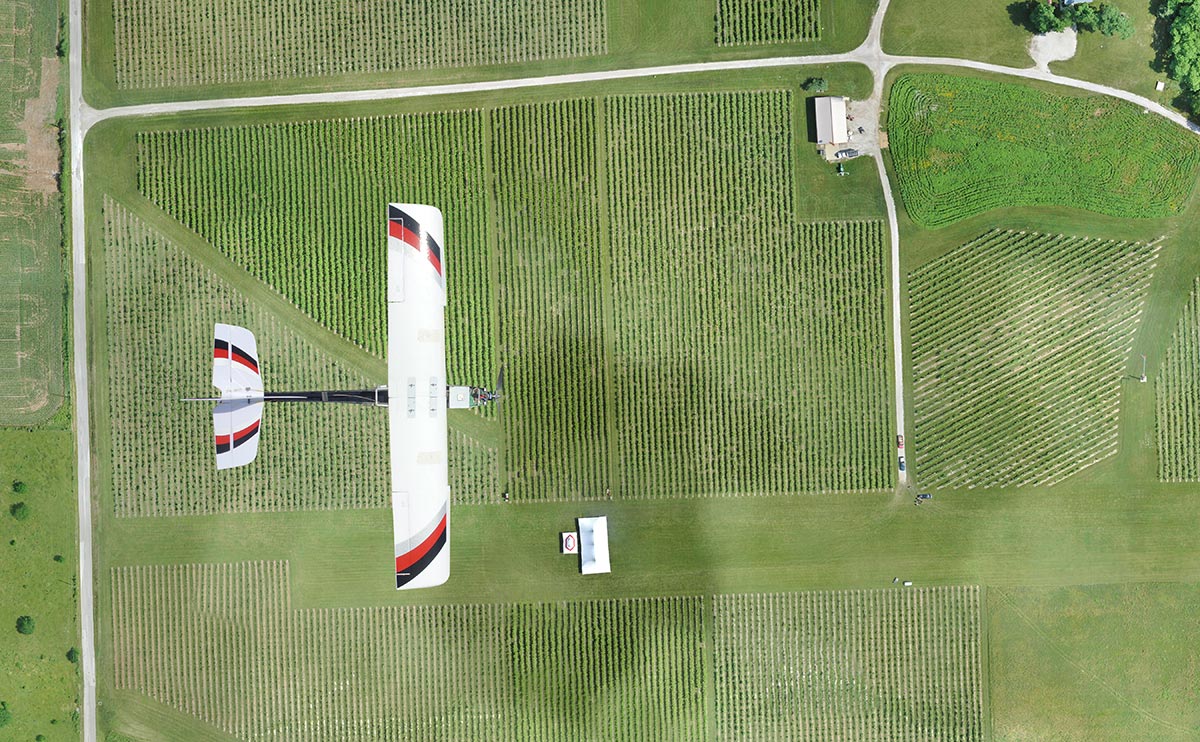
Much has changed since PrecisionHawk launched its first unmanned aerial vehicle (UAV) platform over five years ago. The early model—a four-pound, fixed-wing plane dressed up like a hawk—was used to scare pesky birds away from vineyards. However, we soon learned that viticulture was just a small subset of a data-hungry agriculture market that was embracing the precision agriculture movement.
The power of more information could revolutionize the entire agricultural industry, and commercial use of these tools is on the right path as the FAA draws closer to opening the U.S airspace. But the drone itself is just the first part of the pipeline. While there has been talk about smart farming for many years, growers have often viewed integration as a cumbersome and complicated process. UAV hardware simplifies this process substantially by eliminating unnecessary steps in the field, but the right software and analysis tools are essential for the next steps in farm management.
IMPETUS
Innovation comes from the need to address an existing problem or process that has proven to be inefficient over time. The same applies to agriculture and the integration of drones and data. At this point, traditional methods have not only resulted in a decrease in productivity, but have also contributed to major environmental issues such as drought, resulting from inefficient water use and allocation. In the next 40 years, the world’s population is set to increase from seven billion people to more than nine billion. In order to meet this growing demand, agricultural producers will have to increase food production by 70 to 100 percent. This all needs to happen in a world with increasingly unpredictable weather patterns, ever-rising farm input costs, and limited land to grow on.
In response to this need to produce more with less, farmers have learned that by collecting data in their fields, they could potentially decrease inputs and increase outputs.
Historically, aerial surveying methods, such as satellites or manned aviation, have been used to collect on-farm data, but those technologies are often attached to high costs, untimeliness, and poor ground resolution. By adding drones to their arsenal of farm equipment—as seamlessly as one would introduce a new tractor to the farm—farmers can collect real-time data at high-definition ground resolutions and cut costs in the process.
COMMERCIAL MARKET
According to the Association for Unmanned Vehicle Systems (AUVSI), the UAV market is estimated at $11 billion, and is expected to grow to $140 billion over the next 10 years. As UAV operations shift to the commercial market, speaking from experience, agriculture seems to be taking the lead and agriculture is expected to capture approximately 80% of the known market. Of course that’s not to say that other industries are not cognizant of the recent advancements and wide array of impactful use cases that drones bring to the table. In the last 18 months, we’ve seen interest from other billion dollar sectors such as insurance, utilities, emergency response, mining, and life sciences.
With the FAA seeking to build the most competitive regulatory environment for drones, it clearly doesn’t take much to postulate that UAVs will inevitably become a viable business tool in the future.
In the same regard, precision agriculture is the future of farming. We envision UAVs to become as commonplace as cellphones have in recent years, but realize that in order for growers to fully adopt this technology, they need a reliable hardware and software system that delivers actionable insights.
We expect a steady increase of demand for solution-based technologies that are focused on core agricultural practices. Precision agriculture professionals with deep knowledge in this field will have an advantage when it comes to developing tools and algorithms that can turn data into usable information.
DRONE TECHNOLOGY RUNDOWN
Many people are unfamiliar with some of the technology basics of drones today. Here’s your primer.

source: MrDrone.net
Choosing a UAV
In terms of maneuverability, UAVs are either autonomous (programmed with an extremely high level of artificial intelligence on-board, allowing them to operate completely autonomously) or radio-controlled (as seen in many hobbyist platforms in the market). In theory, both types have the ability to collect data, but the key differentiator is the onboard intelligence, which ensures the user is collecting a quality of data that they can make decisions on. Autonomous UAVs, equipped with on-board flight diagnostic software, are able to detect and adjust to highly volatile elements such as weather and wind speed. By eliminating the human touch point, autonomous UAVs operate with a much lesser degree of error.
On the other side of the spectrum, UAVs are also classified according to their wing configuration—with rotary and fixed-wing being the most widely used. Fixed-wing drones assume the usual airplane design and fly a preprogrammed flight path. Rotary types, with their multi-component propeller system, have the ability to move in several directions—a feature that is essential in unique applications involving more pointed inspections. However to address the need for consistent data sets, as with the case of big business, fixed-wing UAVs have proven to be a much better fit.
Remote sensing
It is a common misconception that more data equates to more information. In truth, actionable information can be attributed to a few elements such as data quality, back-end analysis efficiency and more importantly, sensor choice.
Picking the right sensor for each application is like activating human sensory receptors. Are we able to determine if a surface is rough by smelling it? We can try, but certainly not. Our decisions are shaped by what we are able to sense, and because sensation is the foundation of cognition, picking the most appropriate sensor suite for a certain application is no different.
In these early days, visual and multispectral sensors are seeing the most traction in terms of use cases, across a network of major industries. This increased interest has sparked the development of more options than ever before.
Currently UAV operators are being sold an NDVI collected using a visual a multispectral sensor to look at qualitative data. This is essentially useless in making a quantitative decision, which leads nicely into the importance of information processing and GIS/analysis. Each part of the pipeline needs to fit together in order to provide value to a user. If you can have all of those pieces in one platform, it eliminated confusion and increases efficiency.
Information delivery
Corporations and small businesses are progressively joining us in assuming this data-first mentality. In the last year as we began to break ground in international markets, we noticed a steady uptake of clients who are primarily looking for highly efficient solutions that solve specific problems such as anomaly detection or disease identification. At the end of the day, aerial images don’t mean much if they don’t deliver insights—like measuring crop health and indicating problem areas—that directly contribute to a business’s strategy, operations, and planning.
The challenge we face most often is communicating to customers that the system will work with a farm’s operational flow. This platform is much more valuable than just pictures stored on a memory card—it provides applicable information right away. Educating and highlighting this fact to users is key. You don’t need to be a pilot or aerospace engineer to use this technology. This system is designed to be accessible.