
A few weeks ago we reported about Apple secretly launching its own “Street View” mapping vans. In June Apple has brought to an end all the speculations and launched the official website devoted to Apple Maps vehicles. We can read there:
Apple is driving vehicles around the world to collect data which will be used to improve Apple Maps. Some of this data will be published in future Apple Maps updates. We are committed to protecting your privacy while collecting this data. For example, we will blur faces and license plates on collected images prior to publication.
There is also the official schedule of where the cars will be headed over the next month (starting in the US, UK, and Ireland). But this is the news that you could find on every tech website. Here is what you could find out when reading between the lines.
HOW MANY APPLE MAPPING VANS ARE THERE?
The schedule gives us information about driving plan of the vans but based on it we can also estimate how many Apple vehicles are there. Looking at the initial schedule for June 2015 it seems that there is 1 van in Ireland, 4 in UK (London, East England, South East, West Midlands) and 13 in the US (Tucson, Oakland, Los Angeles, Orlando, Atlanta, Hawaii, Chicago, Boston, Detroit, St. Louis, New York City, Dallas, Fort Worth, Salt Lake City, Seattle). In total 18. In August we can observe increase in the fleet. Three more vans in France, Italy and Sweden, and 14 new vans in the US. It makes it 34 vans and counting. Not too many compared to hundreds of cars in the fleet of TomTom, HERE or Google but it’s a good start and it seems to be growing fast.
HARDWARE – WHAT’S THERE AND HOW MUCH DOES IT COST?
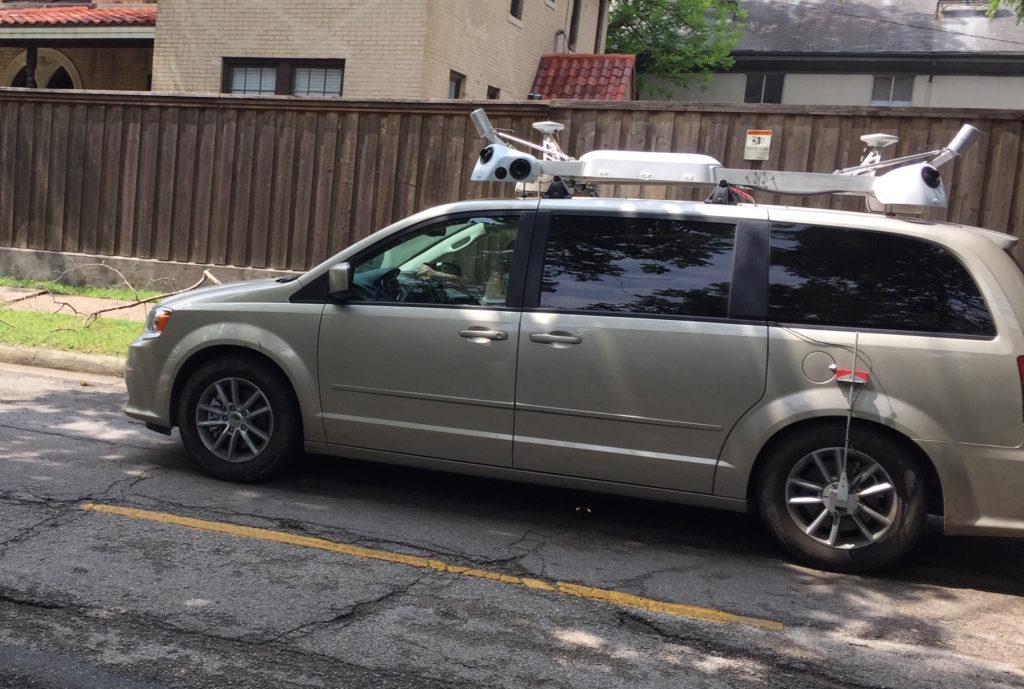
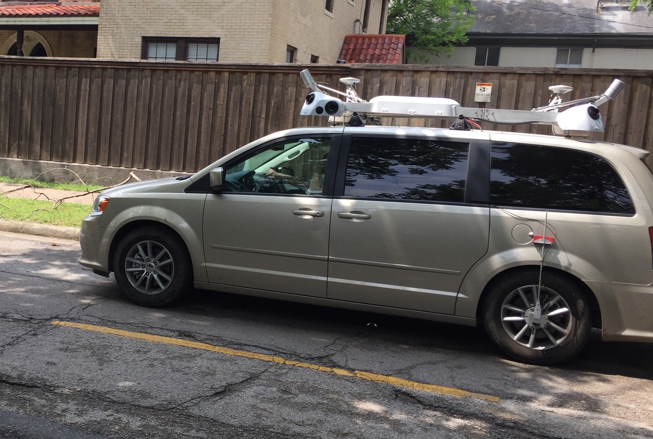
Let’s look closer at the van itself. We’ve seen a couple of images taken by people in US and UK. Based on these pictures we can tell what kind of equipment is installed on the vans, how do does it differ form the mapping vans of major competitors and how much does it all cost?
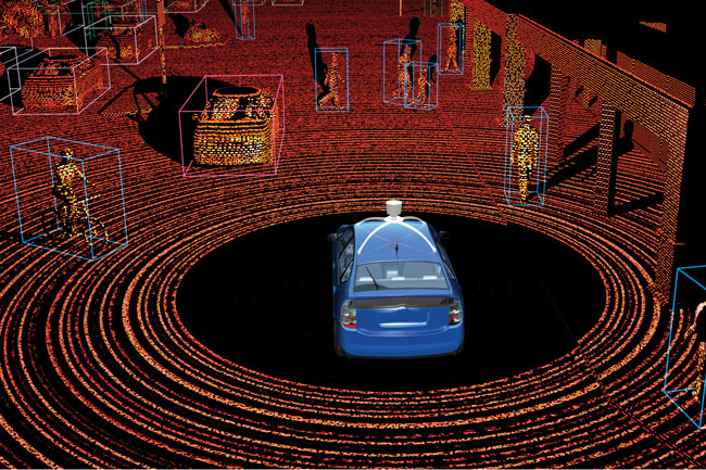
Looking at the rooftop of the van we can immediately notice two Velodyne Lidar lasers. One in the front and one in the back. They scan a terrain up to 80m around and collect a detailed cloud of points at the paced 700 000 points per second. One device cost around $30k so in total $60k for a pair.
There are also two DGPS antennas placed next to each laser. Using two of them makes it more precise and allows for detecting direction and orientation of a van. A pair of antennas should cost around $10k.
Below lasers and antennas, we can notice a massive set of cameras that looks nothing like panoramic solutions of Google, HERE, and TomTom. It rather resembles old Tele Atlas Mobile Mapping Vans which created a stereoscopic 3D view of the road. Four cameras on each corner and two on the side might indicate that Apple is thinking about some kind of “3D Street View” with a detailed HD facade images. Additional benefit of that kind of system is that each camera is placed on the corner so it might not have a shape of a car below each image. It looks like a custom-made system which I would expect to cost around $40k.
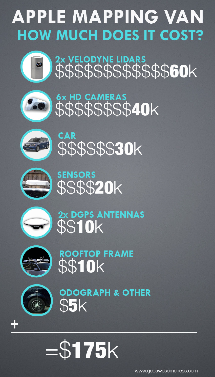 In the central part of the rooftop frame, allow we can see a strange bubbly box. It most likely contains a computer which does some pre-processing of the data in a real-time. Additionally, it most likely contains a gyroscope-based inertial positioning system which allows for positioning when a satellite signal is not available e.g. in tunnels or urban canyons. Knowing that Apple acquired WiFiSlam – a company which specialized in sensing wireless WiFi signals (by driving around cities) for better mobile positioning, we can assume that Apple vans are also equipped with sensors to gather as much signaling data as possible. All this equipment should cost around $20k.
Looking at the hardware, we cannot forget about the custom-made, waterproof roof frame itself which I expect to cost around $10k. All other equipment like wheel odograph (to calculate distance driven with a millimeter accuracy), cabling etc. should add extra $5k.
In total, the equipment on the rooftop of each Apple’s mapping van is worth around $145k. For 34 vans it’s $5 million. The car itself costs around 30k, so additional $1 million for the whole fleet. It total $6 million.
STORING DATA
The mapping van system on the rooftop is only one part of the equation. A single Velodyne laser captures 700 000 points per second which for 2 devices adds up to 5 billion points per hour. Assuming that 1 point is 1 byte we get 5 GB of data every hour. But that’s not all. In order to get high enough of image density each van has to take picture every 10 meters (looking at Google Street View). If we have 6 cameras and every image is 5MB, we get 30MB every couple of seconds. It makes 3GB of images per 1 km. With average speed of 30 km/h (20 mph) we get around 1 TB of data per hour. In total 8TB a day per car.
It’s a lot of data! And it’s all captured in a real-time, which means that it requires a high-speed SSD disks to work effectively. 1TB SSD costs around $500, so $4000 per 8 disks (8TB). Most likely Apple has work out some kind of near real-time post processing of the data. It could reduce the size of a the raw data by at least by 50-75%. None the less even 2-4TB a day is a lot.
We must remember that purpose of capturing roads in that technology is to have the fresh images online as soon as possible. This means that the data must be transferred to a server. I cannot imagine any solution which would work across the world and allow for a stable transfer of 2-8TB of data every day from a single car.
This means that data must be delivered to a server physically. There are two possibilities depending on Apple’s priorities. Vans can have a small data center with 50-100 disks inside trunks and every 1-2 months each van goes to a local Apple office where the data are preprocessed and uploaded to servers. The second scenario is that the data is copied to HDD disks and shipped to offices every couple of days.
In the first scenario, the data would be already 2-3 months old when uploaded to the server. The second solution is more expensive but it allows to get a high freshness of the data.
HOW MUCH ROAD NETWORK CAN APPLE VANS COVER?
Now let’s estimate what can you do with 18 cars? If a car drives 8h a day with an average speed of 40 km/h (25 mph) it can cover around 300 km (185 miles) per day. Assuming that there are 220 working days per year it gives us 66k kilometers (40k miles) per year, which is 1.2m kms (750k miles) for the fleet of 18. For comparison road network of United States is around 6.5 million kilometers. European road network is close to 8 million kms. With 13 cars in the US it’s possible to cover 850k kilometers per year, which stands only for top road classes.
If Apple thinks seriously about it’s mapping project these 18 vans is just a pilot. The truth is that establishing a mature back-office process to make use of the data captured by mapping vans is even a greater challenge. You need a huge server farm, hundreds of people populating spatial database with data based on provided images. Apple needs at least a year to build all of it. Looking at it from that perspective it might mean that Apple will double it’s fleet every couple of months, until it will have a capacity to make use of all of data coming from the field.
WHAT APPLE WILL DO WITH THE DATA?
A lot of people around the world is trying to figure out what will happen with all that captured data. Since Steve Jobs passed away we haven’t seen any disruptive technology coming from Apple. Everyone expects that the company is working on something more than just a regular Street View. The car specs, several of Apple’s patents as well as past acquisitions, indicate that indeed we should expect something more.
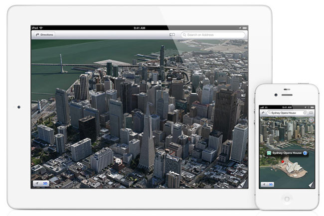
Some of you might remember that back in 2010 Apple acquired a company called 3C Technologies. This Swedish military start-up specialized in airborne Lidar data capturing and its semi automatic post processing. This was the origin of Apple’s Fligh Overs – a cool feature launched together with Apple Maps in 2012, which allows to explore cities using detailed 3D models.
Two Velodyne Lidars in the front and back of the van joined with a cloud point from airplane Lidar scanners and HD stereoscopic images from 6 cameras… It clearly shows that Apple is planning to launch a detailed 3D version of Street View.
AUTONOMOUS CAR?

The specs and the number of vans do not clear indicate that Apple is working on its own autonomous driving system, but the sensors installed on the van are definitely enough to create a map for driverless cars.
The biggest argument against this hypothesis as of today is the number of vans. In order to capture all needed road network only in the US, Apple would need at least 100 vans driving around for 2 years. On the other hand, when you have $150 billion in cash reserves, you can do what ever you want.
Some sources report that Apple is working on a project called “Titan” which is a code name for the company’s electric or autonomous car. Like with any Apple rumor, you’re never too sure what to believe. The iCar rumor isn’t a new one though. In a May 2012 interview Mickey Drexler, who had a seat at Apple’s board of Directors, said that Steve Jobs wanted to rethink the automotive industry before his death.
In fact, Apple may be working on it’s own car but it may never see the light of day. Apple, like many other tech giants such as Google, have potentially hundreds of secret projects that don’t make it to market.

#Business


Next article

Fitness gadgets are everywhere. While majority of these awesome wearable tech gadgets are worn on the wrist, Sony has announced the launch of an interesting wearable that is a headphone. Sony’s Smart B-Trainer is a headphone equipped with six sensors – heart rate, accelerometer, GPS, compass, gyroscope, barometer. The all-in-one Smart B-Trainer will be available this fall in USA for $249.00. The device will have 16GB of internal memory and weighs 43g.
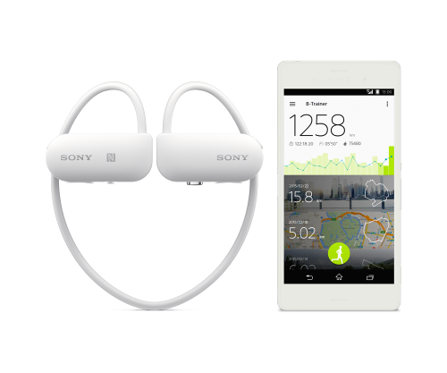
Sony Smart-B Trainer
A Fitness Headphone
Sony has been in the fitness devices market for a while now and this new device is targeted at “power-users”, since the device has a maximum battery life of 6 hours. There are not many fitness headphones with GPS and other sensors and this might just help Sony. One of the interesting features of the Smart B-Trainer app is the automatic song selection based on your heart rate. Pretty neat. Although its not a novel feature, it would still be interesting to see how well it works. (Smart B-Trainer Specs sheet).
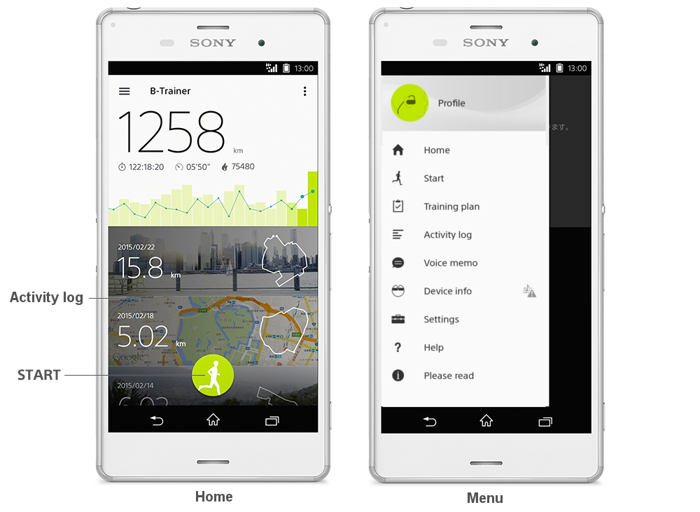
Smart B-Trainer App
Fitness Apps and Gadgets
Fitness apps and data are quite valuable, Adidas recently bought runtastic for EUR 220 million. The Fitbit IPO was a great success and the company is now valued at a few billion ($5 billion approximately) and interestingly was one of the few companies that was profitable when it went for the public offering. Apple Watch was primarily marketed as your fitness guru and going by the all the insight articles (Apple Watch sales figures) on the sales figure, it would be safe to assume, more than a million devices were sold. From making the world-famous Walkman series to making Fitness headphones with GPS, Sony has come a long way. Headphone with GPS is a cool idea. Lets see how well it’s received in the market.
Fitness Gadgets and Geospatial
Wearable Tech and Fitness gadgets are here to stay. This means the spatial community gets to make cool analysis and visualizations like this Runkeeper map by Mapbox.
Location data and analysis is already being used by everyone and I guess this quote by the CTO of Ubisense, Peter Batty fits my sentiment perfectly
Traditional GIS is a tiny portion of the geospatial ecosystem these days, I really dislike the whole attitude that GIS is this specialized sacred thing, and that you need to be a trained “GIS Professional” to do anything with geospatial data. – Peter Batty to Geohipster
At the end of day, the GIS industry isn’t the only one that is using maps and location data anymore, everyone is and that’s geoawesome!