
We want to bridge the disconnect between Geo-research and Geotech.
Geographic information systems (GIS) was once a mere concept of quantitative and computational geography. Thanks to Michael Goodchild, research on key topics such as spatial analysis and visualization were formalized.
While serving as an assistant professor, Roger Tomlinson worked as the manager of the computer mapping division at Spartan Air services. His pioneering work to plan and developer the Roger Tomlinson’s pioneering work to initiate, plan, and develop the Canada Geographic Information System resulted in the first computerized GIS in the world in 1963. Both of these legends were working in the university when they changed the future by creating what we today call GIS.
Fast forward to today, What are scientists and researchers doing with location data? What are the biggest research projects in the universities concerning geospatial data and analysis? Once finished with our studies or academic careers, it is easy to be distanced away from the research world. At Geoawesomeness, we would like to do our part to bridge the disconnect between Geo-research and Geotech and help usher in further innovation and collaboration in the industry.

So far…
At Geoawesomeness, we’ve previously helped researchers with their work by sharing information about their research surveys and by blogging about the state of GIScience. Knowing that there are so many research institutions working in the domain of GIScience and that many other topics are becoming inherently location-based, we have barely scratched the surface when it comes to showing our audience what’s going on at the forefront of science! No one knows about the latest happenings in the research world better than you researchers working in the field!
Hence, we have decided that we are actively going to invite more people to write about their work and research with the rest of our community. We’re very curious about what problems you’re trying to solve, what approaches you’re taking, and what you’ve learned so far. Writing about your research will help you reach a wide and enthusiastic audience, with Geoawesomeness reaching over 170 000 page visits each month! It will also help accelerate the adoption of
We are passionate about exploring the intersection of science, technology, and location and usually write about all topics where we see such a connection. While the definition of a geo-topic is open by nature, just to give you a better example,
We’re interested in
- AR/VR,
- autonomous driving, computer vision, navigation,
- big data (geospatial),
- blockchain, decentralization
- citizen science
- drones, remote sensing, photogrammetry
- location intelligence, location data analytics,
- machine learning, AI
- mobility as a service, smart cities, and many more!
If you are working as a researcher either at the university or at a research lab, this is your chance to share your work outside the academic world. Who knows? Perhaps your work is going to change the industry just like how Michael Goodchild and Roger Tomlinson did in the past century. Send me an email or say hello to us via Twitter 🙂


#Ideas


Next article
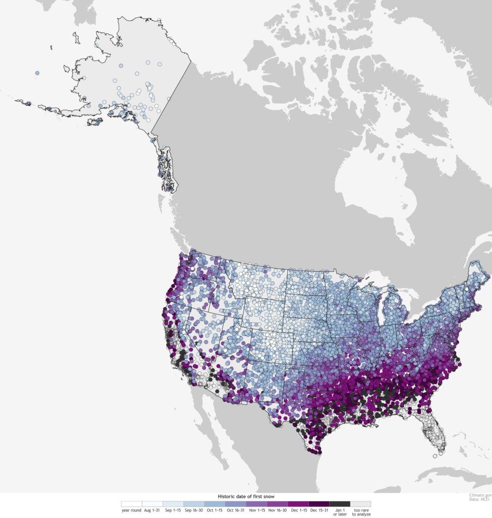

Much of the northeastern United States received the first snow of 2018 in mid-November – but not many were happy about it. The problem was not that the winter blizzard caught unsuspecting residents by surprise, but that it disrupted travel, littered the roads with motor accidents, and left more than 300,000 without power.
But, was mid-November really too early for snow? There’s an easy way to find out. The nation’s official climate record keepers have come up with a handy, interactive map that ballparks the first day of snow for the entire United States, down to the zip code level. The map draws on historical climate data to determine when exactly the chances of your first date with snow would rise to at least 50%. The dataset is based on climate patterns from 1981-2010 – the same one your local weatherperson uses to tell you the ‘normal high’ of the day.

The good folks at the National Oceanic and Atmospheric Administration (NOAA), Oceanic and Atmospheric Research (OAR), Climate Program Office (CPO), climate.gov, and NOAA National Centers for Environmental Information joined forces to make this map possible. Check it out its interactive version here.
You will notice how the highest elevation areas like the Rockies have an almost year-round snow threat, while Hawaii has many regions where it snows so infrequently that no date could be listed? Naturally, latitude and altitude play a clear role in governing the average day of your first snow. Also, pay attention to the line stretching roughly from the Texas panhandle to Chicago. The earlier dates plunge farther southward in the plains because the coldest air accompanied by winter storms often barrels down the high plains.
Another interesting observation can be found near the southern shores of the Great Lakes. This region encounters winter precipitation rather early because the northerly winds of autumn pick up a lot of moisture from the still-relatively-warm lakes. Now, did your annual first date with snow go as expected this year?