As we celebrate ten years of Geoawesomeness, this is a perfect time to reflect on the past decade with an outlook for the future. Here are my geospatial predictions for, what I hope will soon become, the roaring twenties.
- Autonomous first
With more and more drones filling our airspace, the commodity of sensors, the aftermath of Covid-19 and climate change, autonomous operations will start to invade our daily lives. I’m not only referring to autonomous vehicles like self-driving cars, but organizations of all kinds will start to automate operations by incorporating location intelligence combined with artificial intelligence into enterprise systems and workflows. This will result in remote monitoring of assets and infrastructure, significantly reducing manual inspection processes. Think about identifying vegetation that is too close to a power line and likely to cause a wildfire, detecting missing manhole covers before an incident happens, or discovering damaged solar panels.
- The real deal
For thousands of years, humankind has used maps to understand the environment and find our way home. Today, there are many visual methods for depicting real, simulated, or fictional geospatial worlds. Augmented and virtual reality can create immersive experiences anywhere in the field and can be easily consumed using a simple smart phone. One of the early adopters of this trend is Pokémon Go. Virtual reality can be used for realistic and immersive education, planning, and training. Augmented reality will, amongst other things, display different types of vehicles to make it easier for pilots to access critical information without breaking focus from the reality in front of them.
- Enter GaaS
After the rapid expansion of the cloud computing market in recent years, the geospatial industry will also secure its spot in the cloud. “Where” will seamlessly be integrated into our ability to collect, analyze, and disseminate data in the cloud. Functionalities of these Geospatial-as-a-Service (GaaS) platforms will be restricted only by imagination. With GaaS, geospatial software will also be available for organizations operating on limited budgets, thanks to its “credit card swipe” approach.
- The case for space
While space is already key for a number of geospatial operations, such as remote sensing, space will get a prominent place in the geospatial future with human explorations of Mars and commercial space flights around the corner. While mapping the entire universe seems a long way ahead, the use of more antennas on space systems and new signalling capacity will help us create accurate 3D maps for planning and real-time monitoring of space events.
Unfortunately, I’m not able to predict the accuracy of my predictions, but I’ll conclude with the wise words of Abraham Lincoln: “The best way to predict the future is to create it.”

#Business


Next article
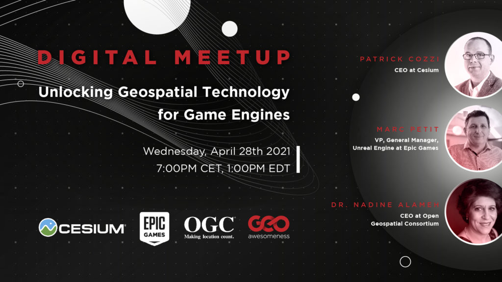
It’s too good to be true but I’ve done it. Our next meetup will explore the intersection of gaming and geospatial tech and we will have three amazing people discussing it:
Patrick Cozzi – CEO of Cesium
Marc Petit – VP of Epic Games
Dr Nadine Alameh – CEO of Open Geospatial Consortium
Join us for free and bring your questions to a one-of-a-kind virtual event on April 28. Together with the community, we’ll discuss how geospatial and gaming can benefit from each other, that what openness and interoperability have to do with it.
Register here.
The agenda and details regarding the talks are available here.
About Geoawesomeness Digital Meetup
The main objective for us to host these meetups is to bring together the geospatial community to talk about the latest and greatest in the geospatial sector. Think of these events as an open-source project aimed at enabling conversations and cross-industry cooperation. Each event has at least one speaker from the industry that is using geospatial data and tools to solve problems.
In 2020, we hosted 8 meetups in total and we had a blast doing it. More than 3000 GeoGeeks from all over the world attended the events so if you are looking for (virtual) opportunities to network with the geospatial community, the Geoawesomeness Digital Meetup is the place to be!
The event is hosted by Muthu and Aleks. You will find their contact details below.
| Muthu | https://www.linkedin.com/in/muthukumarkumar | |
| Aleks | https://www.linkedin.com/in/aleksanderbuczkowski/ |