
Google Maps API, launched only a few months after the Google Maps website in 2005, has completed 15 summers around the sun. And to commemorate this occasion, the Google Maps Platform team is expanding the capabilities of its products intending to deliver more contextualized experiences. Here’s what’s new:
Local Context beta launch
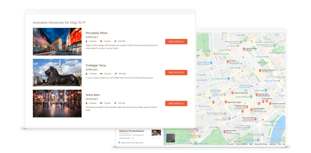
You know how people switch back and forth between multiple tabs while trying to get the sense of a place? Like, looking at a hotel or real estate listing on one window and Google Maps on the other? Google has come to realize that this process can be frustrating enough to impact the conversion rate negatively in many cases.

Therefore, Local Context beta will enable businesses to embed the familiar Google Maps experience into their desktop or mobile web app. This, Google hopes, will help users make quicker decisions, minimize site abandonment, and improve conversions.
“It helps you keep users engaged on your site by giving them a detailed understanding of places near a specific location they’re considering – place names, descriptions, price level, ratings, reviews, and photos. It even provides estimated time of arrival and walking directions from the location of interest,” explains Ivan Passos, Product Manager.
Don’t want a potential customer to discover a competitor nearby? No problem; simply limit the types of places and the number of places you want your users to see.
Related: Google Maps turns 15 with new logo, updates, and reflections from C-suite
Maps customization in the cloud
This new feature, born out of user feedback, will allow you to stylize maps in the Cloud Console and manage them without ever touching a line of code. We are talking more customization, easier management, and faster deployment of tests and new features.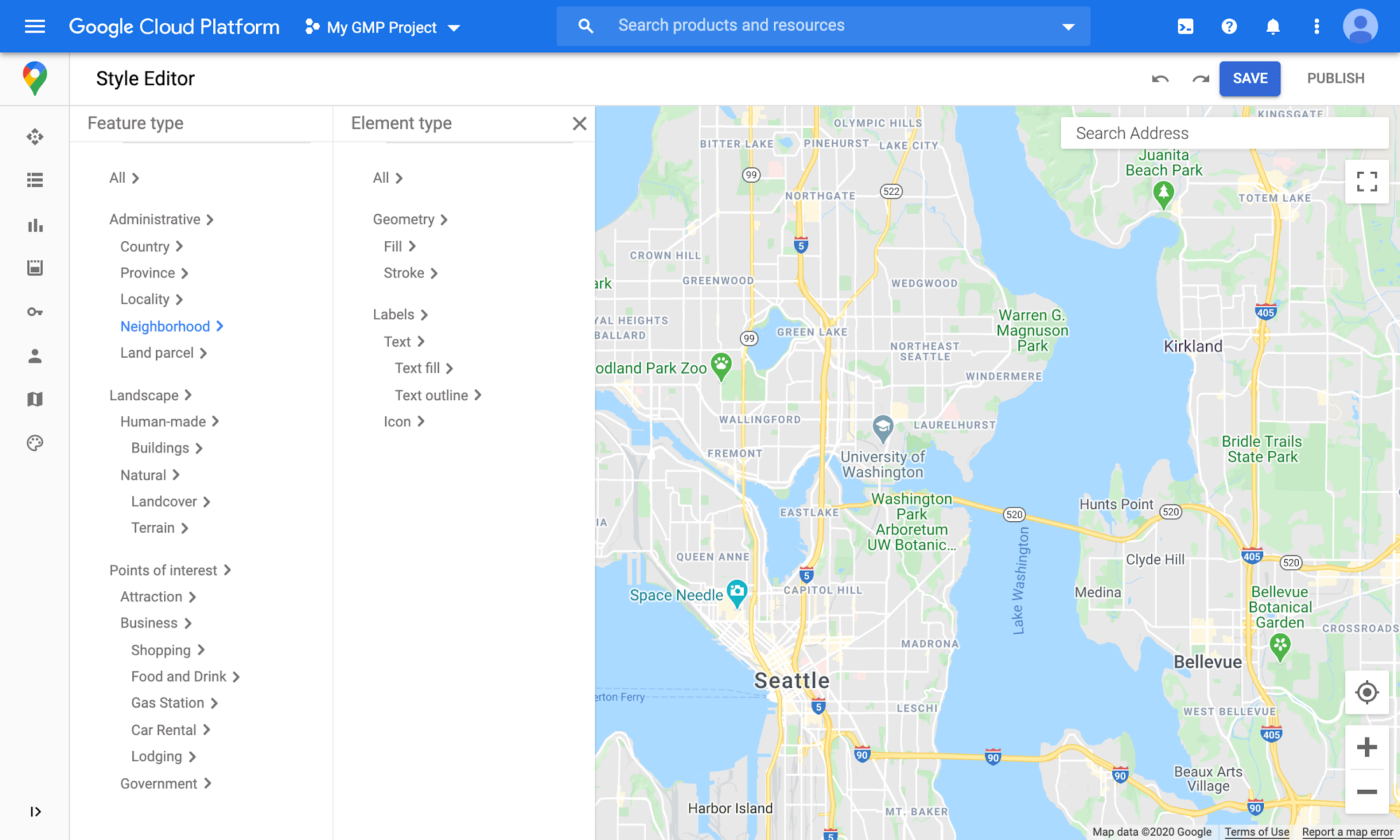
“Until now, Maps customization has been handled via client-side JSON which was sent to the server with map requests. This design meant the amount of customization that could be done was capped by URL character limits. We’ve heard from our customers – and experienced ourselves – how quickly that limit can be hit when styling a map,” Ryan Cassidy, Product Manager, says.
Cloud-based Maps styling will increase the number of customizations that can be done on a map to over 250 for most browsers. Further, any change you make in a Map style will automatically reflect across your entire range of apps and sites in real-time, without any complicated manual deployments.
Also see: Google’s open-source digital addressing system Plus Codes
Expanding gaming solution
After working with a limited group of game studios for the last two years, Google has opened its gaming services to all developers. Any game studio or independent game developer can now build engaging and immersive game environments based on real-world buildings, roads, parks, etc. from more than 220 countries and territories around the world.
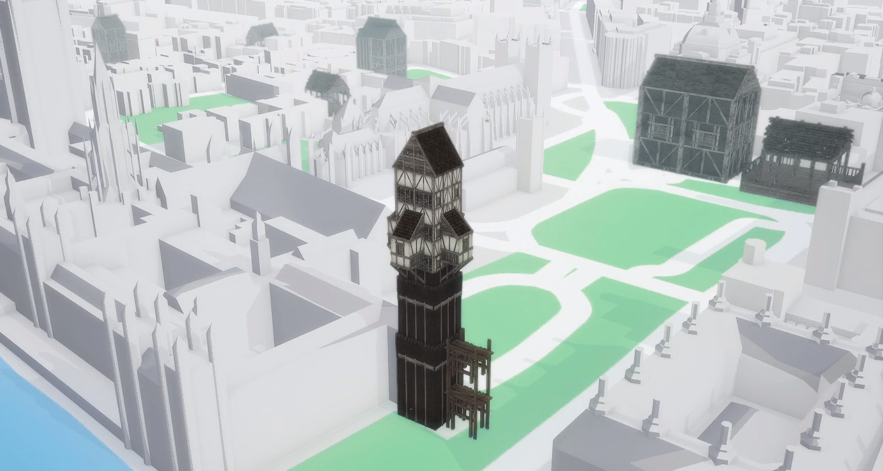
Apart from building a scalable infrastructure that would allow game developers to get started quickly, the Google Maps Platform team has also added new features like Mixed Zoom and Pathfinding in the last couple of years.
Mixed zoom renders a high level of detail for areas close to a player, while areas further away display progressively lower levels of detail. And Pathfinding empowers you to bring new life to your in-game characters, such as directing monsters to chase a player around or collaborating on missions through a futuristic city.
Must read: How often do Google Maps get updated?
Google is also improving its tooling and resources to better support Kotlin, Swift, and JavaScript developers.

#Featured

Next article


Alastair Graham
“The remote sensing community has spent several decades asking for more data. To say now we have too much data would be really churlish,” Alastair Graham quips on a recent episode of The MapScaping Podcast. “I firmly believe we need more open data, not just from government agencies but also from commercial enterprises.”
Alastair, an independent spatial and environmental consultant with more than 20 years of experience in the GIS industry, was pointing to how we should be looking at better management of open geospatial data. This, he believes, can be achieved by using a more standardized approach to data management and collaborating closely with machine learning and artificial intelligence experts. The following open-source projects could help us get there in the near future, Alastair says.
1. SpatioTemporal Asset Catalog (STAC)
 The STAC specification provides a common language to describe a range of geospatial information, so it can more easily be indexed and discovered. A ‘spatiotemporal asset’ is any file that represents information about the earth captured in a certain space and time. The goal is for all providers of spatiotemporal assets (Imagery, SAR, Point Clouds, Data Cubes, Full Motion Video, etc.) to expose their data as SpatioTemporal Asset Catalogs (STAC), so that new code doesn’t need to be written whenever a new data set or API is released.
2. openEO
![]() openEO develops an open API to connect R, Python, JavaScript, and other clients to big Earth observation cloud back-ends in a simple and unified way. With such an API, each client can work with every back-end, and it becomes possible to compare back-ends in terms of capacity, cost, and results (validation, reproducibility).
openEO develops an open API to connect R, Python, JavaScript, and other clients to big Earth observation cloud back-ends in a simple and unified way. With such an API, each client can work with every back-end, and it becomes possible to compare back-ends in terms of capacity, cost, and results (validation, reproducibility).
3. Raster Vision
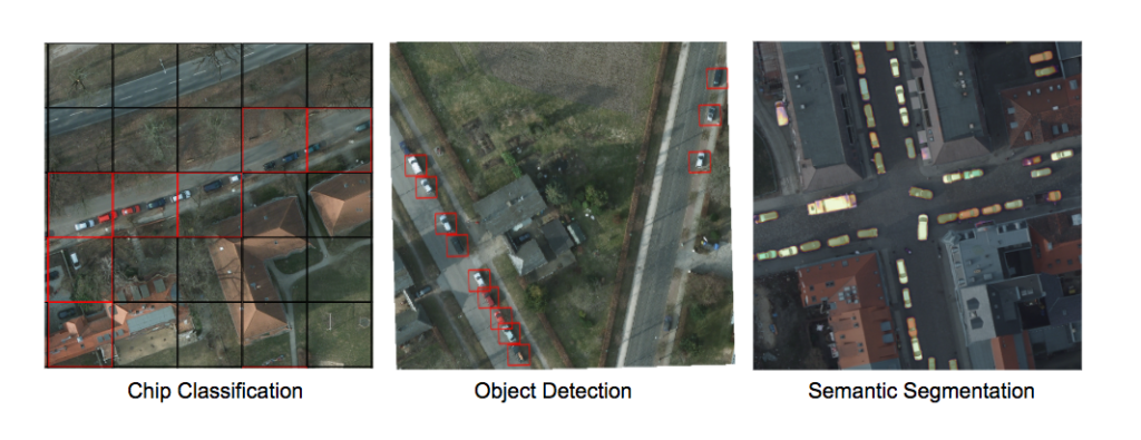
Courtesy: Raster Vision
Raster Vision is an open source framework for deep learning on satellite and aerial imagery. Python developers building computer vision models on satellite, aerial, and other large imagery sets (including oblique drone imagery) can leverage Raster Vision’s built-in support for chip classification, object detection, and semantic segmentation using PyTorch and Tensorflow.
“There’s tons of data in a single image, especially if it is a multi-band image,” Alastair says. “People would usually use that image or a series of images to look at one single thing. I’m still waiting for an application that would take high-resolution satellite or aerial imagery and pull all the information out from the many different thematic areas – right from tree cover rooftop area collection to the number of lights on a street.”
Alastair is convinced that the EO industry would become unstoppable if humans and machines find a complementary working model, i.e., humans feed machines with better training data and machines help humans to extract better insights faster from the troves of open data. “Whatever mistakes the remote sensing community may have made in last few decades must not get repeated just because machine learning experts come from a different domain or view things from a different perspective,” Alastair stresses.
Listen to the full podcast here: