
 Geoporters ( Geospatial Educators Opportunities for Partnership Outreach Research and Training) are seeking for active and passive Geo-Interested individuals to contribute in global Geo-awareness and Spatial Thinking programs. Taking Geo to the grassroots and spreading the good news of spatial thinking.
This is a crowdsourced funding drive courtesy of the GIS:YES (Youth and Educational Solutions). The main essence is zero down geospatial technologies and spatial thinking to the grassroots, the local residents.
The pilot project that took place in Bahia, Costa Rica has the following to report according to GIS learning:
Goals:
- Educate, train, and build capacity of residents in Bahía Ballena and other coastal communities to apply GIS and GPS to investigate, better understand, and take action in environmentally-based community identified projects.
- Engage teachers and students in formal and informal education settings in project-based learning using geospatial technologies to enhance their communities and apply skills to future paths.
- Empower communities to apply acquired geospatial and other technological skills to investigate their own community resources and contribute to solving critical global issues.
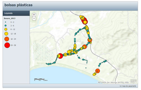
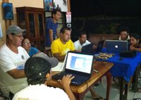
Over the course of a year in Bahia Ballena, Geoporter was able to teach 10% of the community in how to use GIS and GPS to identify and map out local concerns. The residents have participated in projects such as mapping daily humpback whale sightings in Marino Ballena National Park and collecting GIS data about trash collected from local beaches and streets.
This can be replicated in your locality borrowing leave from what took place in Bahia Ballena. Geo-people let us find a way to contribute to this laudable program and continue to take Geo beyond the gates.
Learn more about how you can start your contribution and participation in Geoporter on indiegogo.com.
Follow Geoporters activities on facebook.com for more information.
Source: Gislounge.com

#Business


Next article

TED talks have kept me busy off late and I have watched talks on pretty much everything from African symbology to Peace negotiations, Engineering happiness to GIS! Some have been interesting while one talk in particular was simply Geoawesome! Which one? Its by the talk Bill Davenhall,ESRI’s Global Marketing Manager for Health and Human Services Solution on Geomedicine! Unlike other TED talks, this is not going to take you longer than 10 minutes which is an added bonus and one more solid reason why you should really watch it 😉
Now if you think GeoMedicine, the industry jargon for Geospatial Information in Medicine is a recent phenomenon think again! Remember the “London Cholera Map” by Dr. Snow. Dr. Snow is for sure the “father of medical mapping” like Iyke here at Geoawesomeness likes to call him. GIS has been used in health related applications pretty much similar to the London Cholera map but more importantly GIS and GeoMedicine are finding their way into the latest technology i.e. Electronic Health Records. These are not only going to highlight the risks of a particular region to say Lung Cancer which is the usual research behind Health GIS solutions but you as an individual could actually make health choices based on your travel history. Here’s the link to a recent article on Electronic Health Records and how GIS/Geography is playing a role in it.
I believe the difference between Health GIS and GeoMedicine is this, Health GIS = evaluating the Health risks of a particular place whereas GeoMedicine = Adding your geographic history to evaluate your health risks. While one might argue that Health GIS is a subset of the latter and that is also the truth but in a sense GeoMedicine makes it more valuable than just a set of map that show you the risk of malaria in your region! In no way am I discounting the value of such a map but GeoMedicine is simply Health GIS V 10.0! ESRI has an amazing collection of articles on this topic, here’s the link to a presentation by ESRI on Geomedicine and here’s the link to ESRI’s homepage on Geomedicine.
The question is not ” Can Geographic Information keep you healthy? “, the question is how can we utilize geographic information to take care of ourselves and live a better life. (Read more: The role of Wearable Tech and Internet of Things in Geomedicine).
What are your thoughts?