

I’m glad to say that Geo-awesomeness blog became a media partner of The Location Business Summit Europe 2012. It’s the must attend conference for the location and mobile marketing industry in Europe!
It is a fact that many companies are struggling to monetize their Location-Based Services and this might be the answer to many problems due to exchange of knowledge and networking with top Mobile/Geo/LBS professionals.
It is a fact that many companies are struggling to monetize their Location-Based Services and this might be the answer to many problems due to exchange of knowledge and networking with top Mobile/Geo/LBS professionals.
Speakers from companies including Google, Starbucks, Heineken, PayPal, Vodafone, Nokia and Living Social among others seem to be enough to encourage you to join.
Additionally quote GEOAWESOME and get €100 off any ticket price.
Additionally quote GEOAWESOME and get €100 off any ticket price.

#Business


Next article
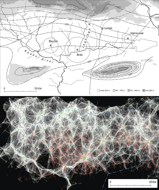
When on the hunt for ancient civilizations, it’s not about being Indiana Jones. It is known that archaeologists use for example Google Earth for their studies but now they went a step further and have developed a method of spotting smaller human settlements by combining spy-satellite photos obtained in the 1960s with modern multispectral images and digital maps of Earth’s surface. The approach was used to map some 14,000 settlement sites spanning eight millennia in 23,000 square kilometres of northeastern Syria.
The Scientists from Harvard University in Cambridge trained an algorithm to detect ‘anthrosol’, a type of soil formed by long-term human activity, from multi-spectral satellite images. Containing a higher levels of organic matter, anthrosols impart a different texture and appearance to untouched soil, giving it a distinct visual signature. It this process automation was key, “You could do this with the naked eye using Google Earth to look for sites, but this method takes the subjectivity out of it by defining spectral characteristics that bounce off of archaeological sites,” says Jason Ur – anthropologist who specializes in early urbanism and cultural landscapes in the ancient Near East.
Scientists as well used digital elevation data collected in 2000 by the space shuttle as part of NASA’s Shuttle Radar Topography Mission (SRTM). This information enabled them to estimate the volume of the larger sites for the first time — and to use this volume as a proxy for a site’s longevity. The bigger the mound, the longer the settlement survived which is a way to quantify a site’s long-term attractiveness to human populations.
source: Nature