London Gatwick Airport Launches a New Geospatial Platform to Manage Buried Assets and Support Biodiversity

We like to keep our eyes on all things spatial at Geoawesomeness. This new industry development caught our attention as brings together some flourishing technologies and trending topics: geospatial platforms, digital twins, and democratizing geospatial data.
London Gatwick Airport has created a new geospatial platform using Esri’s GIS (Geographic Information System) to support multiple operational areas, including engineering and environmental services. The platform reduces the risk of airport disruption from accidental damage to utilities and helps to manage environmental impacts.
It integrates all spatial data into a single view. Combined with advanced spatial analysis tools, mobile apps, and a dashboard, the Esri platform provides new insights to support better collaboration and decision-making across the airport.

London Gatwick is using the geospatial platform to support its Biodiversity Action Plan.
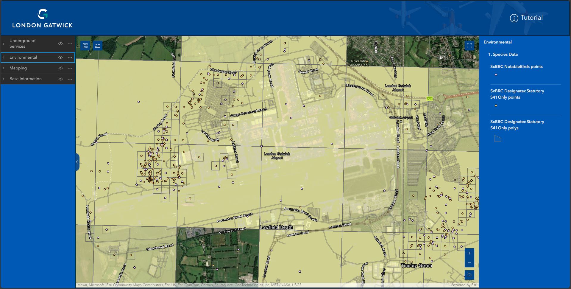
The airport is using the platform to support its award-winning Biodiversity Action Plan, designed to deliver a biodiversity net gain at London Gatwick by 2030. London Gatwick’s 1,600-acre site is home to 75 hectares of woodlands, grasslands and wetlands, as well as hundreds of species of mammals, birds, insects and bees.
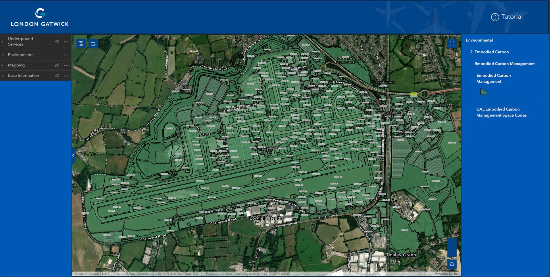
The geospatial platform gathers environmental data such as protected, rare or invasive alien species, bat box locations, notable birds and environmental stewardship areas. It also visualizes the estimated embodied carbon of built assets.
Insights from the GIS allow London Gatwick to plan works around any environmentally sensitive sites to minimize impact and seek ways to bring additional benefits, such as improving biodiversity.
The single view of buried assets including gas, electricity, telecoms, water, and fuel, is proving critical in reducing accidental damage to utilities across the 1,600-acre site.
Field engineers, third-party contractors and major consulting firms all use the same single view of data, accessible on any device when planning excavations. With up to 50 engineering and construction projects on-site at any one time, the new system is making work safer and reducing the risk of disruption to airport operations from any unplanned outages.
“Being able to visualize and interrogate all spatial data from any discipline, on any device, is critical to the sustainable future of London Gatwick. Democratizing spatial data in this way drives significantly more business and operational value from it,” explained Simon Richardson, Digital Information Lead, London Gatwick Airport.

Simon Richardson, Digital Information Lead, London Gatwick.
“The Esri GIS has given us the foundation to create a digital twin. As a complex site with over 70 years of history, we are building a virtual representation of what has previously been built along with future plans, which helps manage the airport’s development.”
London Gatwick selected GIS from Esri UK following a competitive tender. Previously, the airport used Autodesk’s Infrastructure Map Server to manage spatial data but looked for another GIS software vendor when the product became unsupported.
“We selected GIS from Esri UK because its Managed Cloud Service made it more accessible at lower cost than an on-premise approach,” continued Richardson. “It also removes the burden of system management and updates, which saves a significant amount of time, allowing more resource to focus on strategic projects. The new system is quicker and easier to use and the benefits far outweigh the cost.”
The geospatial platform visualizes critical infrastructure information spanning the 70-year history of the airport.
The system is already making engineering and construction work safer by reducing accidental strikes on buried utilities and enabling better management of the airports’ biodiversity.
With the rise of digital twins and London Gatwick’s platform being a foundation for one, this type of technology is one to watch as cities, towns, airports and more build virtual representations of the past, present, and future. Mirroring our complex world in this way enables us to gain smart, connected insights that transform decision-making.
What are your thoughts on London Gatwick’s geospatial platform? On airports utilizing digital twins? Is this a new frontier for innovation and efficiency? Where do you see the global airport digital twin market going in the coming years? We’re curious to see if airport operators try to keep pace with the technology of the future and if regulators will drive innovation in the coming years.
Let us know what you think!
Did you like the article about London Gatwick’s new geospatial platform? Read more and subscribe to our monthly newsletter!
#Environment
Next article


Addresses are a ubiquitous part of our daily lives: they serve as the backdrop to every place we go, every item we order online, and every service we register for. As a result, we take them for granted, rarely thinking much about their many vital uses—or how they have come about. More than just sequences of numbers and letters designed to guide mail delivery, addresses are a complex interweaving of human and physical geography; through urban layouts and street names they tell stories of cities, towns, and the natural environment, but also of societal structures, conflicts, and change.
These rich stories have created a complex web of diverse and dynamic data. But in our increasingly interconnected global economy, having an accurate and reliable address system has never been more important—both in the digital and physical world. When an individual provides an organization with their address, for example by typing it into a multi-field form online, the organization needs to be able to validate that data: to check it is ‘deliverable’ and to understand its location. Our traditional system of assigning addresses is struggling to keep pace.
Enter Geo Addressing. To put it simply Geo Addressing is “bringing accuracy, consistency and context to addressing data, in other words, data integrity for addresses. However, the process is not without its challenges, and it’s a field that requires us to confront the diversity and dynamism of our world head-on. Our ‘Geo Addressing Decoded’ series will look at the importance of accurate address systems, the challenges, some of the innovative solutions being developed and their many applications. In this first article, we will start by looking in detail at the challenges presented by the traditional addressing system and conventional datasets.
The Dynamic Address: A Global Challenge
In his “Addressing What Matters” series, Mike Ashmore – Sr. Director of Product Management at Precisely, highlights the fact that addresses are dynamic entities, subject to change due to urban development, political shifts, or administrative refinements. In the UK, for instance, an astonishing 4.5% of addresses underwent a change last year. Many of these were minor, such as spelling corrections, but the alteration of even a single character can create duplicates in a digital address database. In a more striking case, the municipal restructuring of Quebec in the early 2000s incorporated many outlying towns into the new Quebec City, resulting in 922 duplicate street names. To avoid confusion for postal and emergency services, many of them were subsequently renamed, creating additional complications.
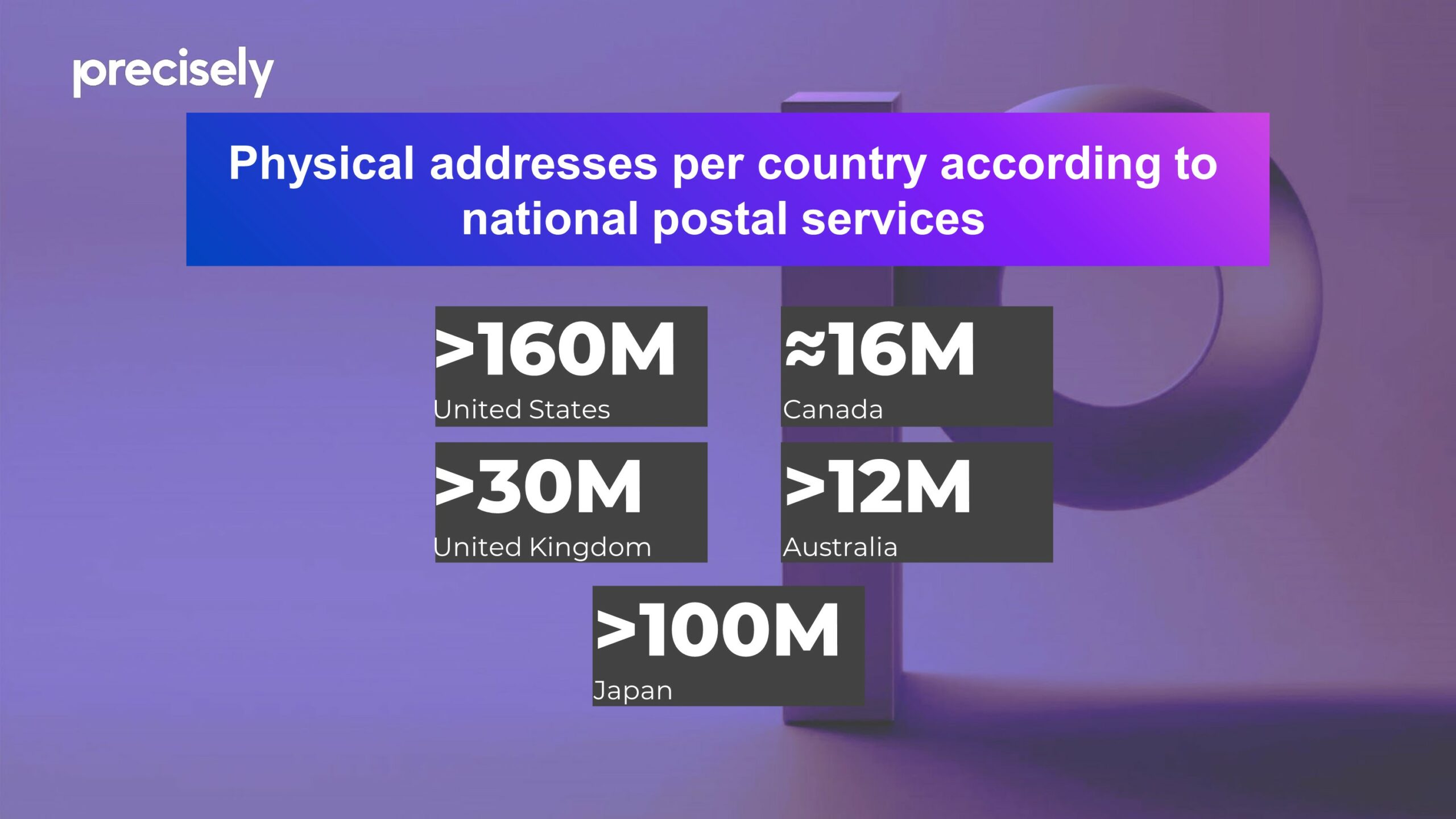
Why Does Geo Addressing Matter? – Amount of addresses around the world
To take another example, in 2017, a re-survey of the border between North and South Carolina led to a tweak in the official state boundary, which, although tiny on a global scale, led to dozens of properties technically moving from one state to the other, with legal and financial repercussions. And on the most extreme end of the scale, there are plenty of examples of entire countries changing their names, either due to conflicts or due to a rejection of a colonial past (like eSwatini, formerly Swaziland), something that address systems need to accommodate.
There can also be huge diversity in addressing systems around the world, with some unique methods of allocating addresses. In Colombia, for instance, addresses are based on a grid system, with a structured code indicating the street and the distance in meters from the nearest junction. Japanese addresses, by contrast, are based on areas, from big to small (prefecture, county, town, neighbourhood, block, apartment). In New York, there is a common practice of ‘co-naming’ streets for political or sentimental reasons, and as a result something like 2,000 streets have both a formal and an honorific name, only one of which is recognised by postal services.
Furthermore, nearly half the world’s population lacks a formal address entirely! This problem persists not only in developing countries, where ‘descriptive’ addresses are common, but even in rural areas of developed nations like the United States.
An Inconsistent and Incomplete System
It’s a challenging landscape, but organizations need accurate address data, whether they are delivering goods, providing services, or gathering information about a property. Unfortunately, in addition to the complications outlined above, collecting that data is also a challenge due a lack of definitive sources.
Postal services, where they exist, offer one of the most reliable sources of address data, but even they have their limitations. Not every legitimate location receives direct delivery from the postal service. On the other hand, not every postal delivery point translates directly to a physical location: A PO box address is really an instruction to the post office to hold mail for the receiver; a military vessel at sea will technically have an address, but it won’t tell you where the ship physically is. To take a more everyday example, in a large apartment block, mail may be delivered to individual mailboxes in a communal area, so the delivery point does not correspond to the physical location of the property.
This highlights a broader point: the existence of an address does not necessarily mean its location is known—or understood. This is notable in the case of new developments, where it is normal for addresses to be assigned to a location during the planning stage of a development, before the physical infrastructure actually exists, creating a temporary discrepancy between the address on paper and physical reality.
The factors above give an impression of the difficulty faced by any business or organization which uses address data. They are left with inconsistent, incomplete data, and a continuous battle to keep it up to date with ‘ground truth’.
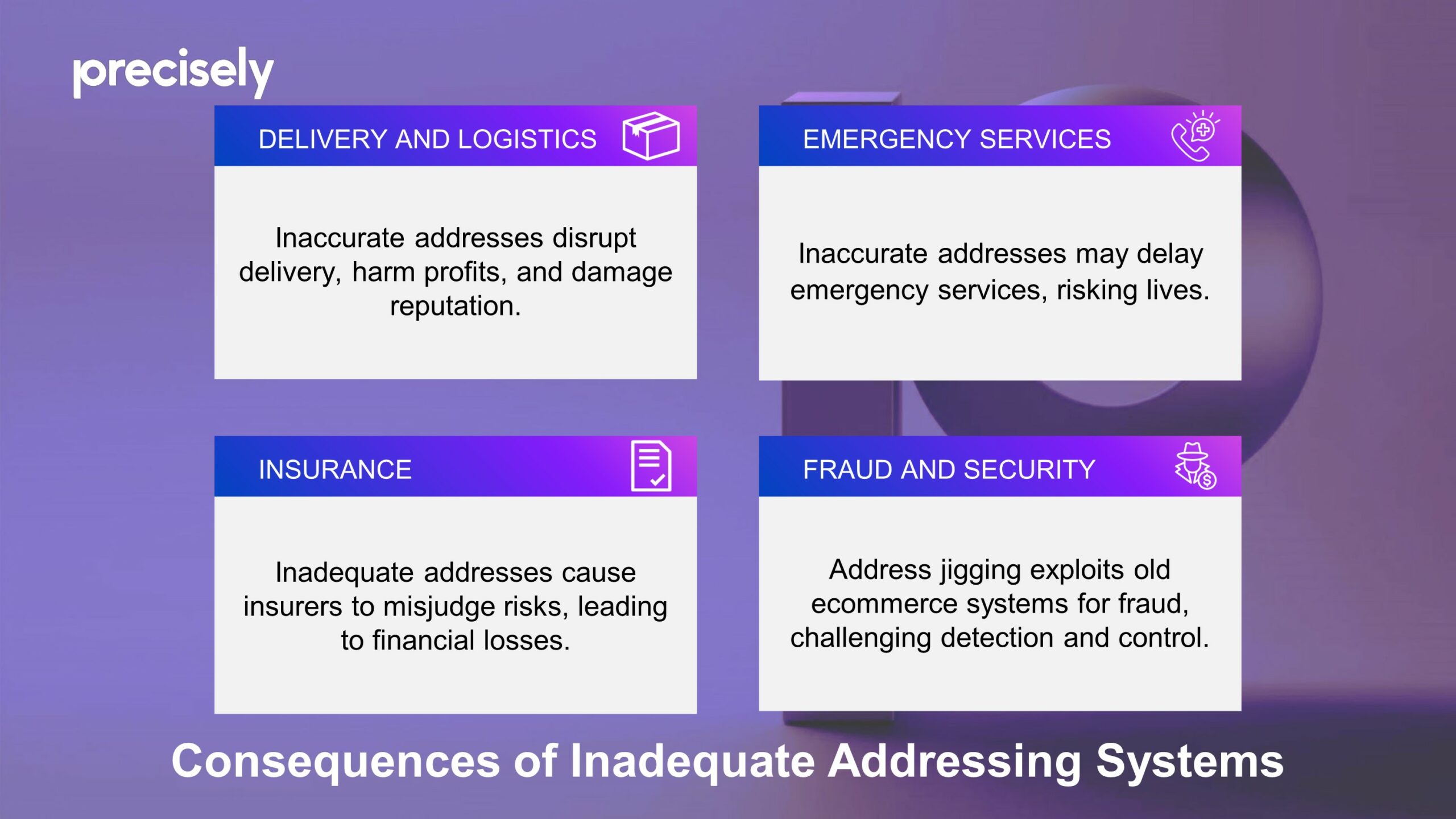
Consequences of Inadequate Addressing Systems
The impact of inadequate addressing systems extends across many different sectors, each of which experiences unique challenges.
- Delivery and Logistics: For companies shipping goods, bad address data can break down the entire delivery chain. Incorrect addresses can cause delays, failed deliveries and, at worst, lost packages, which all result in a direct hit to businesses’ profits and reputation. With an increase in same-day delivery and automated ecommerce systems, the accuracy of address systems is more crucial than ever.
- Emergency Services: Emergency services rely on precise and quick location identification to provide timely assistance during crises. When addresses are incorrect or incomplete, response times can be significantly delayed, with potentially devastating consequences. Accurate addressing can literally be the difference between life and death.
- Insurance: Perhaps less obvious, but inaccurate addressing also spells trouble for insurance companies. Precision is key for insurers to properly evaluate risks: If they misjudge a property’s location due to bad address data, they might set premiums too low for high-risk areas, which can lead to significant losses during events like natural disasters.
- Fraud and security: Address jigging, a fraud tactic that involves subtly altering shipping addresses to exploit ecommerce vulnerabilities, initially emerged among sneaker enthusiasts. It allows a buyer to circumnavigate ‘one-per-customer’ deals, enabling them to secure large quantities of valuable items or free samples, from drugs to electronics. The technique has evolved, powered by sophisticated bots, and detecting such activities and catching the perpetrators can be a complicated process. Address jigging only works because many ecommerce companies are using old-fashioned address systems.
Why Does Geo Addressing Matter? – Impact for sectors of life
The Path Forward: A Future of Precise Addressing
The examples above point to the ongoing need for improvements in addressing solutions to accommodate the needs of a globalized economy and the expectations of consumers and businesses alike. Our traditional system of assigning addresses is struggling to keep up. As we navigate the complexities of our increasingly interconnected world, the importance of developing and implementing advanced addressing solutions cannot be overstated.
Thankfully, innovative technologies are now here, promising to make every address accurate and easily findable, and paving the way for a future where accurate, reliable, and universally accessible addresses are a given. The next article in this series will delve deeper into the future of address systems and the technological solutions ensuring no one is left off the map.
In the meantime, consider the addresses that populate your life—the places you call home or work, or choose to visit. Each carries a story, a set of data, and a link to the wider world, underscoring the profound impact of addresses on our collective and individual experiences. Beyond their practical utility for navigation, they are a fundamental part of our identity.
About Precisely
Precisely is a global leader in data integrity, providing 12,000 customers in more than 100 countries, including 99 of the Fortune 100, with accuracy, consistency, and context in their data. Precisely’s data integration, data quality, data governance, location intelligence and data enrichment products enable better business decisions to drive better results. Learn more at www.precisely.com
![]()
Did you like the article about Geo Addressing? Read more and subscribe to our monthly newsletter!