
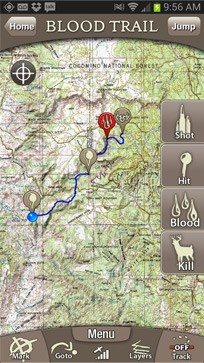
 Hunters are interested in the ownership of the land they are on. They need to know the legal boundaries of the hunting permits and hunting leases. Trimble perceived this necessity and developed an android application that allows viewing ownership maps off-the-grid without a cell or data signal. Additionally, GPS functionality enables to navigate in the field. The new application was launched this week under the name GPS Hunt Topo Map SD Cards for Hunters. The app works on Android-powered smart phones with a SD/microSD slot. The memory cards are also compatible with iPhones and iPods. So far the maps cover 39 US states gathering information on more than 167 million private plots, which so far is the most comprehensive collection of land ownership available on smart phones. After plugging the memory card into the mobile phone and loading the maps, those can be viewed without a cell phone or data connection. In areas off the cell phone towers, where hunters often circulate, this is a very important feature. Users can retrieve the full colour topographic maps in 15 different levels of zoom. Three super-zoom levels permit the detections of boundary objects (fences, stones, etc.) in reality.
In contrast to US, the land ownerships in Europe are much smaller. Hunters and hunting association mostly know the boundaries of the hunting permit very well by memory. This app appears to be developed for areas with large land ownerhips like the US, Canada, Australia, etc.
Source: Trimble

#Business


Next article
 I guess most of us has been in a such a situation: you are in a new neighbourhood which doesn’t seem to safe and the last thing you want to do is to use your HTC One or iPhone 5 to check the directions and give strange guys around a clear message: “I’m not from here and I’ve got a piece of expensive equipment.”
The solution is simple and yet I haven’t seen it in any other project. Techcrunch Disrupt Hackathon entrant – Kovert is an app that will let you do one simple thing. It will allow you to enter the destination address and then it will guide you by buzzing in your pocket on every intersection. Once for a left, twice to go straight, three times to turn right, and ten times when you’ve reached your end point. Great idea. Such solutions are used in navigation for visually impaired people but it might be of a use for all of us. Kovert will also include a compass feature which vibrates when you are pointing in the right direction.
I like this idea because it has a clear use case and user scenario and it enhances your experience with a such a simple solution. The app should be available soon. We will review it once it’s out in app store.
source: TechCrunch