
Have you tried out 3D scanning tech yet? It’s well worth a look for anyone who is in the architectural, engineering and construction space, as well as facilities managers and a whole range of other industries.
It’s a great time to try 3D laser scanners as they are becoming much more widely available and affordable on the market. A range of scanners exist, from tripod-mounted to handheld scanners; the latest iPhone 12 Pro even includes 3D scanning technology in the phone’s camera, though they aren’t detailed enough for more than quick checks on small elements of a project.
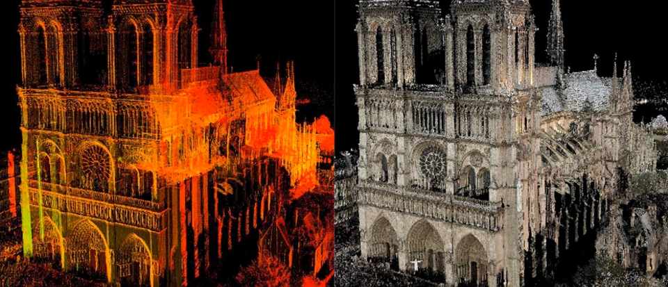
If you have already tried it out, you’ll no doubt have seen the scans you can generate – also known as point clouds. They look pretty simple – but in truth, there’s a lot to understand about point clouds if you’re to get the best value out of them, and by extension your investment in 3D scanning tech.
What are point clouds?
Point clouds are, in essence, very simple. They are datasets that are made up of ‘points.’ Each point represents something – a part of a wall, window, or wire, for instance – and the point contains information on where that part is in space. Together, these points form an image of whatever you had scanned.
Millions of points make up a point cloud – billions, if you are scanning a large building or complex. Viewed from a distance in point cloud software, they look a bit like impressionist paintings – and up close, you can see all the individual points that make up the scan.
On their own, point clouds don’t do much – you need point cloud software to extract value from that data.
What is point cloud software?
Point clouds require specialist software to view and manipulate then. Firstly, before point cloud data can be viewed it must be ‘registered’ so that the data all lines up and looks like the object or space you have scanned. This is especially important if you are stitching multiple point clouds together.
Because every point has data about where it is in space, you can also use point clouds to take incredibly accurate measurements of a space, calculate volumes, and more. Again, point cloud software is needed to do this.
Point cloud software can also provide a way for you to use point cloud data in other software applications. For AEC professionals, for instance, point cloud data is incredibly useful in 3D design tools as the basis for their designs. Construction firms may also want to feed point cloud data into their BIM plans, so they can compare as-built conditions with their plans as construction unfolds. Facilities managers can also use point clouds to get accurate floorplans of their buildings, and to help them plan projects – for instance, rearranging machinery on a factory floor for manufacturing a new product.
This is arguably one of the most important functions of point cloud software. But point clouds are often very large files – so large in fact, that they require specialist computers to work with. This is because most point clouds are actually made up of multiple scans. The lasers from 3D laser scanners can’t penetrate through walls, meaning that to capture the entirety of a structure, multiple scans are often required. Those point clouds are then stitched togther. The right point cloud software converts those point clouds into a smaller and more usable format that’s compatible with other software packages. Without point cloud software, it’s very hard or even impossible to use point cloud data – making the investment in 3D laser scanners a waste.
Where can I get point cloud software?
Most 3D scanners will come with their own software, which will allow you to do some things with your point clouds, including registering them and taking measurements from them. However, if you want to export your point cloud data to other applications such as Revit, you will likely need additional point cloud software to handle the process. There is a variety of ways in which point cloud data can be made to work with other applications, some of which are more complicated than others – the right software can make the process much smoother by automating some elements, such as classifying points (identifying them as walls, cables, or similar) or creating usable BIM objects from the data that can be used in lots of 3D design applicatons.
Whatever methodology you use, it’s important to understand that finding ways to use your point cloud data is an essential part of maximising the benefits of 3D laser scanners. The information scanners can generate, and therefore the value they can provide professionals in a range of industries, is immense – but only if those professionals have the tools to make use of the data the scanners output. Most scanners will come with their own software for registering point clouds, but those applications won’t often talk to other downstream systems easily. Therefore, it’s important to find software that seamlessly integrates with whatever hardware you are using. Once that part of the process is in place, there’s no stopping you from unleashing the potential of LiDAR and point clouds.
Author Bio:
Mark Senior
Mark has a strong background in Building Construction and Land Surveying. He has been at the forefront of significant technology changes in the Geospatial industry over the last 25 years. He is the business director at PointFuse, a leading BIM Coordination software. He has been involved with PointFuse since its conception, shaping its development from bleeding edge technology to the successful commercial solution it is today.


#Business


Next article

6 years ago, Aleksander Buczkowski and I created the 1st #GlobalTop100Geo companies list with the objective of helping our community understand the industry ecosystem better and to enable collaboration and innovation.
When we first published the list Aleks and I had little idea that it would turn into an annual tradition and one of the biggest projects that Geoawesomeness and the team will undertake each year.
2022 is a really special year for us and for the #GlobalTop100Geo list. We have a powerhouse panel (Nadine Alameh, Denise McKenzie, Justyna Redelkiewicz, Carly Morris, Eldrige De Melo, Olivia Powell, Sives Govender, Jonathan Neufeld, Osamu Ochiai, Siau Yong NG 黄晓勇) working to create the list!
Hope you will benefit from the list and enjoy reviewing it as much as we have and a huge thanks to our panelists for their dedication and enthusiasm, the whole process wouldn’t have been possible without them.
The 2022 list will be published on 31st January 2022. Hope you will join us for the live event – register here.