
Editor’s note: This article written by the Satelligence team is part of the annual GeoTrends series. GeoTrends series aims to provide a platform for thought leaders, executives and strategic thinkers in the industry to articulate their vision and help our readers understand where the industry is headed in the future.
AI is proving to be the key to unlocking the supply chain quagmire; empowering farmers at the frontline of supply chains to lead the fight against deforestation by making sure they’re fairly compensated.
Deforestation related to agriculture is responsible for 15% of global greenhouse gas emissions.
A wave of sustainability commitments from some of the world’s largest businesses has created unprecedented demand for tools that can help companies identify and mitigate deforestation in their supply chains. New laws such as the EU’s Regulation on Deforestation Free Products will soon place mandatory obligations on companies to eliminate deforestation from their supply chains in order to keep trading on the EU market.
In order to stay within our planetary limits, companies and countries know they must act fast to make deforestation-free supply chains a reality. But company supply chains are huge operations spanning multiple countries, companies, and legal frameworks.
How AI Empowers Farmers To Fight Climate Change
On the one hand, smallholder farmers in the first mile of supply chains are squeezed from both sides by a need to clear more land for expansion and by demands for emissions reductions from manufacturers.
On the other, the race to net zero has corporations around the globe cutting emissions to meet climate commitments. For now, some of these emissions are unavoidable, so companies are compensating with carbon offsets.
For the first time, developments in AI machine learning have made it possible to measure precisely how much carbon has been captured and sequestered as a result of the agroforestry practices on individual smallholder farms. The carbon is converted into CRU’s (Carbon Removal Units) which are sold on the Voluntary Carbon Market. As much as 80% of the revenue from the sale can go directly to farmers, providing a significant incentive to nurture the trees on their land rather than cut them down.
CRUs are ex-post, meaning that each Unit sold represents one tonne of carbon that has already been removed from the atmosphere. This differs from the majority of carbon credits, which are sold before removal. More than just a novel application of AI, this nuance helps assuage concerns over the speculative nature of the carbon market.
Fulfilling the Potential of Applied AI: How does it work?
An AI-powered carbon estimation machine learning model based on satellite imagery is used to estimate the amount of stored carbon in plots at regular intervals. Those plots represent farm plot boundaries, which are catalogued in partnership with industry and local NGOs.
In order for machine learning to predict carbon stock, three components are needed:
- Farm plot field data as a training set
- Satellite imagery as a feature set
- A Random Forest machine learning model
With these ingredients, you can teach the model to estimate carbon levels based on the feature set to track changes over time. It can convert satellite images of plots into units of sequestered carbon that are organised farm by farm.
Improving Accuracy Over Time
Scalability is crucial, and repeatability and traceability are the cornerstones of scalability. One of the biggest challenges in using AI to achieve scalability is coping with variations in farm plot field data, as different companies across different countries submit data in different ways. Divergent interpretations and a lack of homogeneity across training data sets create issues with local bias. The predictive capability of the model can only ever be as good as the training data set it’s drawn from.
In practice, this means that modelling approaches are tied to the ecological region they’re drawn from. They aren’t transferable to locations where the environmental conditions are entirely different.
AI machine learning has been crucial in overcoming these obstacles. an ISAE-3000 Type 1 Certified quality control audit process has been developed for each type of environment, country or commodity, a form of meta-algorithm, that allows carbon modelling approaches to be adapted to any ecological region.
With the ISAE-3000 certified algorithm, companies can use the same quality control process to map Cocoa in the Ivory Coast as they could to Palm oil in Indonesia.
AI Facilitates Human Creativity
The project leverages the ability of AI to discover and repeat patterns that are too complicated for humans to recognise, or too boring for them to repeat, enabling engineers to apply their expertise to analyse, curate and fix errors in the data. Experts are then free to focus on fixing external abnormalities like clouds, atmospheric disturbances and noise, so the product can be continuously improved.
Thanks to innovations in AI, the otherwise costly and complex process of scaling carbon footprinting measurements across global commodities is getting simpler by the day.


#Environment


Next article

It has been a productive 4 months since I last wrote in September. I have been very busy. In that time I have assembled this watchlist. This was a project I began in August last year. It became an obsession for me. I stayed up until 2am twice, a couple of times till 1 (including now writing this!), and once until 5:30am. The latter was when I manually adjusted all 100+ positions for stock splits. Splits can get crazy. I believe most of the work finding businesses to add to it is done though.
Categorising the list
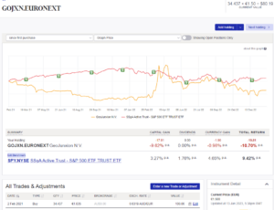
The list contains 144 pure play and adjacent geospatial companies, globally. I classify them as pure play if they are geospatial, navigation, CAD, surveying, earth observation etc companies. They might sell services, products or equipment. An example is Maxar. This started its public equity life on the Toronto Stock Exchange as MacDonald Dettwiler on 2000-07-12. The initial price was $CAD14, it is now 69. It has compounded at 7% annually since then. If you purchased $100 in shares at the IPO, it’s now worth ~450. You would have beaten the S&P 500 Index by 2%. A very large amount over generations of compounding.
There are many non pure-play firms making very strong impacts though, such as Google. I classify this as a company adjacent to our industry. For example, their Google Maps product is one of the most installed apps of all time and the most popular navigation app by far. The industry, and the quality of life improvements caused by it, would be less without Google’s geospatial products and services. Therefore, such companies appear in The Geospatial Index.
It would also involve significant financial loss not to include such companies. Google has been in the Index since its 2004 IPO because that is also the year they bought Keyhole. This would become Google Earth in 2005, along with a release of Google Maps the same year. Since IPO to now it has compounded at 20% annually. $100 of stock is now worth 2700.
Survivorship Bias
So, what is the performance of this as a fund? This is difficult to assess due to survivorship bias. This is a common problem when doing so-called back testing. You shouldn’t make conclusions about performance based just on the companies trading now. This is because what’s missing are the majority of companies: those that never made it. There are many permutations actually.
For example, another way a company could disappear from an exchange is through being acquired. Consider Mobileye. It went public, then got acquired by Intel, then got spun off last year as something individually tradable again. Business is complicated. Cardno is no longer traded, shareholders have had their capital returned after it was acquired.
An expression of these types of outcomes is the 17 sell trades in the portfolio. An example of a sell was McDonalds after they sold Quintillian, the store location mapping software they developed in house. Another was Pitney Bowes after they sold MapInfo. But I also have MapInfo in there for the period it was a public company, it no longer is. This is all really hard work.
Because all of this is so complicated, it is costly to purchase datasets of the trading history of all companies, including the ones no longer in existence. I don’t have the money for this. Intrinio has been in touch on Twitter offering a free trial but I haven’t heard anything more. I am, however, building a network that helps. For example, whilst attending Geomob Barcelona I met Rafael Roset. He is 2 from my right:
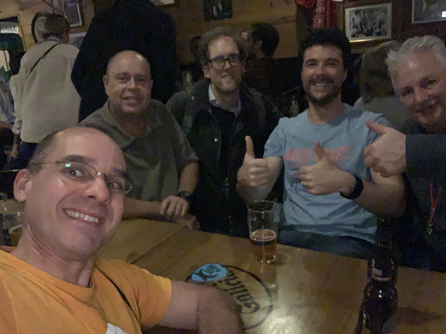
He is a senior geospatial professional in the city. He was kind enough to tell me about Telcontar, acquired by DeCarta, subsequently acquired by Uber. The way it usually goes is I then see if I can find any history of all participating firms being publicly traded at any point, and have that history in the index. I am unable to find any of those. The same issue has occurred for ESL Incorporated and TRW Inc (which subsequently acquired it).
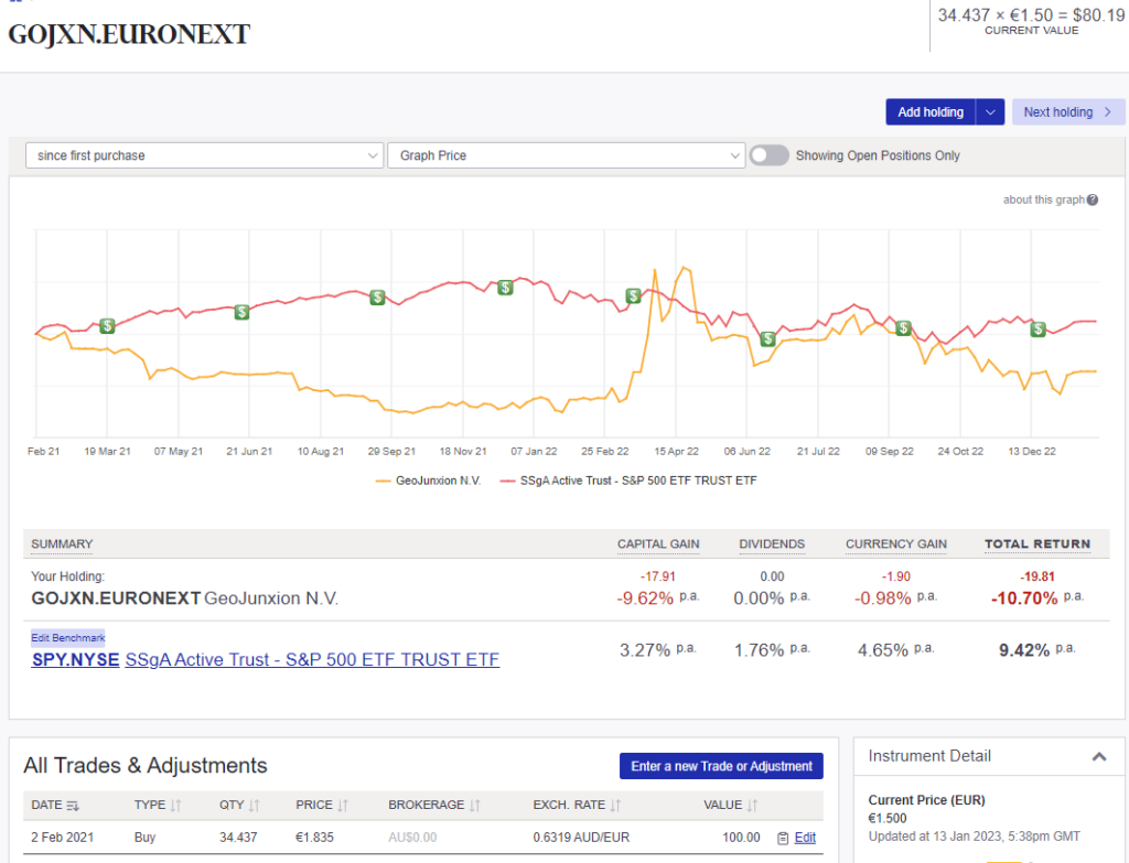
Raf also nominated a Dutch geospatial firm called GeoJunxion:
I was able to add this one as it is still traded today. You can see they have not performed well now that the COVID stock market mania is over.
So, yes, I admit I am withholding from you the performance of the index so far. I think I have a misleading impression of the market more than 10 years ago. There are still many good things it has done, however, for me as a professional. It is a great way to stay abreast of developments in our industry. Knowing that each relates to a stock you can trade makes it even more meaningful in my view.
Benefit of Never Selling
Other things to note about the Index is that it is equal weighted: $AUD100 per position. Additionally, the aim is to never sell. The only reason to sell is if, like MacDonald’s selling Quintillian, the company no longer has a geospatial impact on the world. Or if it goes bankrupt etc. A well known investor, Ian Cassel, comments that the practice of never selling sets you up to reap incredible returns through capturing the runaway gains of a few big winners. Kenneth Langone’s experience with Eli Lilly was similar. Chuck Akre says the same.
I will say this much. The Index has dropped only 4% in the past year, whereas the market has dropped 10%!
Sources
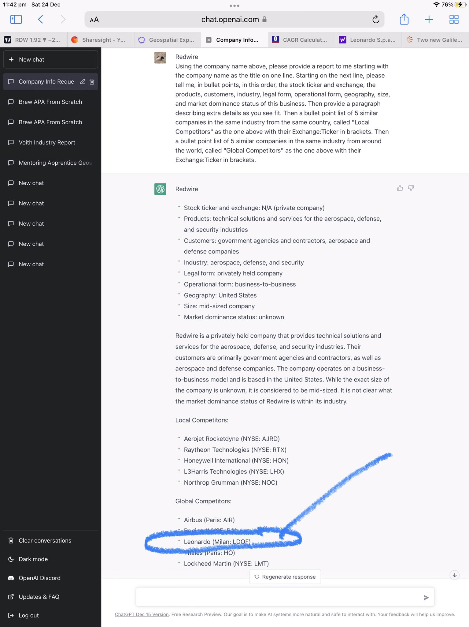
Of course, in the process of building out the Index, I learnt to harness ChatGPT. I gradually engineered the following prompt:
<EXCHANGE:TICKER> (e.g. NYSE:UBER)
Using the company name above, please provide a report to me starting with the company name as the title on one line. Starting on the next line, please tell me, in bullet points, in this order, the stock ticker and exchange, the products, customers, industry, legal form, operational form, geography, size, and market dominance status of this business. Then provide a paragraph describing extra details as you see fit. Then a bullet point list of 5 similar companies in the same industry from the same country, called “Local Competitors” as the one above with their Exchange:Ticker in brackets. Then a bullet point list of 5 similar companies in the same industry from around the world, called “Global Competitors” as the one above with their Exchange:Ticker in brackets.
The results were always interesting. Circled below is Leonardo, a new firm for the index, adjacent to geospatial.
I have found out about companies all over the world, including the US and China, through using ChatGPT in this way.
Other sources of information to build the list:
List of GIS Companies in the World: The Best List You’ve Been Looking For
This Google search.
https://www.appgeo.com/top-satellite-and-aerial-imagery-companies/
This article.
This map.
Even GitHub had something.
This article on spatial computing.
Infographics from @terrawatchspace in 2022 about all things Earth observation👇
1. An overview of the commercial market landscape of EO for climate – segmented into data, solutions, and applications.
Expect more deep dives on EO for various climate applications in 2023 🌍🛰️ pic.twitter.com/AC0i2rPT8L
— Aravind 🌍 🛰 (@aravindEO) December 27, 2022
This article about LiDAR stock carnage.
This, and practically any article from the glorious and righteous Joe Morrison.
This splendid history from Joe Francica.
Continued in Part 2.
A silly sounding site called Datarade was surprisingly useful.
Even the Connect algorithm on Twitter!
I tried everything, even EDGAR’s autocomplete function in company search.
Not to mention plugging every geospatial, navigation, surveying, satellite etc term I could think of into Tradingview’s search function… this was surprisingly useful even for finding firms in China.
Regarding Indian firms, none other than Ujaval Ghandi of Spatial Thoughts helped me out!
An unexpected but amazing resource came from a cryptocurrency project, of all things, Golden. I used it to find an absolute plethora of GEOINT firms. It was at that moment that I realised I have missed the entire geospatial industry, basically, in my career. This is because the biggest geospatial business deals (some of them in the billions) are done by defence companies. I have never worked in defence and probably never will. But some of the products are holo-desk level. I have done some pretty cool things in some of the world’s worst places, but nothing will compare to Saab’s Sandbox.
Next Steps
Maybe this article from Bloomberg best sums things up. The geospatial industry is projected to grow north of a trillion in value by 2031 at a compound annual growth rate of 13%. This is far above the century plus average growth rate in the US and Australian markets of 6.5% after inflation. A basic way to take advantage is the equal weighted index approach I am demonstrating here. After that, you can start to refine things by avoiding companies that are in debt and also those that aren’t generating free cash flows. Another refinement is to wait 6 months to buy after an IPO. They typically drop dramatically. Just look at Innoviz. I will step through an analytical framework to identify such a company next.