
With the recent increase in frequency of flooding events (followed by the usual ‘I haven’t seen this in the past hundred years’ comment), a GIS-related observation came to mind. It is highly unlikely that we will ever be 100% sure in terms of preventing ‘Mother Nature’s rage’, but we do have tools to help with the side effects of these events. So what would be some of the key values when talking about GIS for evaluating watershed conditions and environmental processes affecting them? Technology, Cloud and Collaboration come to mind.
TAKING ADVANTAGE OF TECHNOLOGY
It’s there so why not use it. Different apps and tools are being developed and upgraded constantly so keeping track of them is quite a challenge. Planners, consultants and decision makers recognize the spatial significance of resource management at a water body scale. So here comes GIS to save the day. But how, you might ask yourself? Do I need to be a GIS expert to incorporate tools into a water oriented decision making plan? Not at all as the beauty of GIS is to adapt it to your needs and your workflow. User friendly apps, developed for both GIS and non-GIS experts are ‘the thing’ to look for.
BRING IN THE CLOUD
Why lock yourself to the desktop? Water management thrives on data from the field so having the timely and accurate collected data helps you to:
- understand relationships between variables being monitored
- communicate impacts on water and environment
- compare historic and new data to make effective strategies
So, where is the Cloud in GIS you ask, and where is the connection with water? Cloud helps you to have your newly collected data and previously obtained data available to you from any place, any device, at any time. Follow the progress from the field while being on a different side of the world, and decision making becomes ‘real’ in real time.

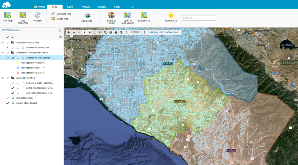
Orange County Watershed Map in GIS Cloud’s Map Editor
COLLABORATE TO THE FULLEST
Isn’t this the most important value of a GIS strategy? Get an input from different departments, different companies, having an insight from the team in the field, as well as in the office… By having a way to collaborate ‘on the go’, you are minimizing your time rate put into a project while getting more out of it in terms of efficiency and accuracy. And who wouldn’t want that.
Bring in different layers of information, manipulate big data sets, share it within your organization and out so that you can easily understand what goes on in watersheds, what processes affect them and what decisions need to be made to preserve them. Because after all, no matter where we live, we live in a watershed.


#Science

Next article

Telenav launches HopOver – new check-in app. Clone of Foursquare or revolution?

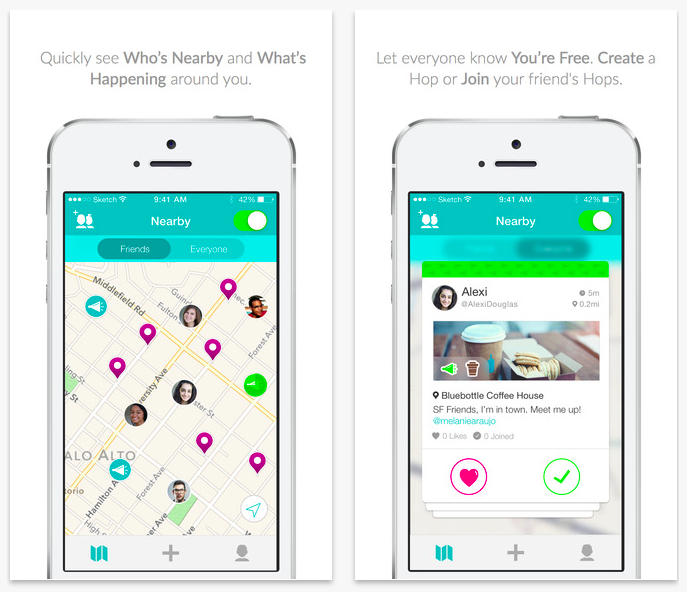
Over the years I’ve seen a lot of different location-based social networks. Typical scenario: you share your location among group of friends or strangers, you can view people nearby on a map and you can interact with them. Where, Plazes, Dodgeball, Sociallight, Loopt, Limbo, Gowalla, BrightKite, Qyoe, Gypsii, Whrrl, TellMeWhere, FireEagle, Moximity, Locassa, SCVNGR, Friendticker and Foursquare. I believe that from this list of location-sharing apps most of you know just the last one. So why should we even write about HopOver?
COOL CONCEPT OR A STRATEGY?
The most interesting fact about HopOver is that it’s developed by Telenav which is a well-known giant in GPS navigation industry. Why is this important? In case of start-ups like Foursquare first there is a cool idea, than the strategy and finally the implementation and launch. In case of big companies first there is a strategy that the portfolio of company should include location-based social network, than there is searching for an idea which would fit the strategy and than there is the implementation and launch. This little difference is what makes Facebook far more popular than Google+.
SOUNDS FEASIBLE
It seems that the strategy of Telenav was to create a second Foursquare. Literally. The app has a very similar functionality to Swarm app by Foursquare. The only important difference is that HopOver is targeting college students which is really a specific audience. This is a very smart move. It’s almost impossible to get a critical mass of users of a location-based app in a city, state or a country in less than few years. But getting a critical mass of users on a single college/university seems feasible, and Telenav said to be soon launching local campaigns at colleges around US. But developing new social media app when you’re big company has also some advantages. You’ve got resources to really make a top class implementation. I must admit that the design of the app really good and I like it a lot.
HOPOVER USES FOURSQUARE DATA
What’s also interesting about the app is that despite the fact that Telenav attempts at coping the concept of Foursquare Swarm app, HopOver is actually leveraging Foursquare’s content for its place data. It shows two things: first of all that Foursquare has clearly moved from being just a check-in app to be a location-based Big Data provider, secondly Foursquare seems not to consider HopOver as a threat to it’s business.
COPY OF FOURSQUARE OR REVOLUTION?
But the question remains: is it just another copy of Foursquare or a real location-based revolution? Clearly there is nothing disruptive about the app. It’s a clone of Foursquare. But the clone which a has a really smart strategy and might actually succeed in it’s targeted audience group.