

It takes a lot of intelligence these days to understand all the apps, platforms, services that you need RIGHT NOW for your business to thrive. It is practically necessary to do some form of data analysis pertaining to your business in today’s world. Your ability to understand what factors affect your business will help you make quality decisions for productive results. In this article, we will explain what is the main difference between Business Intelligence and Location Intelligence.
Understanding your business’s spatial dynamics and how it affects your business requires a lot of data. It would help if you had the right combination of tools to help you understand these data and interpret what it means for your business. The intersection between how location impacts your business and how your business may impact your location is where Location Intelligence and Business Intelligence come to play.
Data analysis and interpretation don’t have to be complex. Either you’re using a simple tool like Excel or a more sophisticated tool like Tableau or Gooddata to help you gain crucial insights to making business intelligent decisions.
Today, there is increasing data availability, and there’s a need to narrow down to the specifics on how it’s interpreted to make business decisions. That’s why it is essential to analyze data through the context of location. In that case, here’s where Location Intelligence (LI) and its tools come into play.
Just as supply is vital to demand, so is the demand for data analysis as data supply grows. There’s a need to understand why and how specific business interactions happen, which we can interpret as Business Intelligence. Understanding why things occur where they do is Location Intelligence. These interactions could grow from simple to complex; hence the need for Business Intelligence and especially Location Intelligence tools increases.
Let’s see the main differences between the two disciplines and how BI and LI can get along with each other to get the most out of your data. We will show you how it works on a real example.
To demonstrate the differences between BI and LI, we have chosen one tool from each; Tableau represents the team Business Intelligence, and CleverMaps stands for the Location Intelligence team.
The showcase project is Traffic accidents in the US.
The Business Intelligence approach: Know your numbers
With the aid of a business intelligence tool, you can easily visualize your data and draw a meaningful inference that will help you gain productive results. They allow you to integrate or import data from multiple sources, computing and visualizing them for your understanding in real-time.
The good thing about it is that anyone on your team can process the outputs, and even if you are not tech-savvy, you’ll find some of the visualizations pretty handy without being bored with all of the technical jargon.
For instance, BI tools like Gooddata, Tableau and Power BI will show you data trends. Imagine running a Unisex footwear e-commerce store, and your data reveals that you have more females buying from you than males. Then you’ve got powerful insight for your business on your hands. You can do many things with this information; you might want to observe why only females are buying and probably retarget your Ads for males. Or maybe it is females who are buying the shoes for males. Such is BI tools’ power, and there are ample resources to help you make effective business decisions.
Such is BI tools’ power, and there are ample resources to help you make effective business decisions.
BI tools can also help you generate predictive analyses for your decision-making. It allows you to understand what your dataset means and probable outcomes from such trends in the near future. With this information, you can predict how your decisions will impact your current business standing.
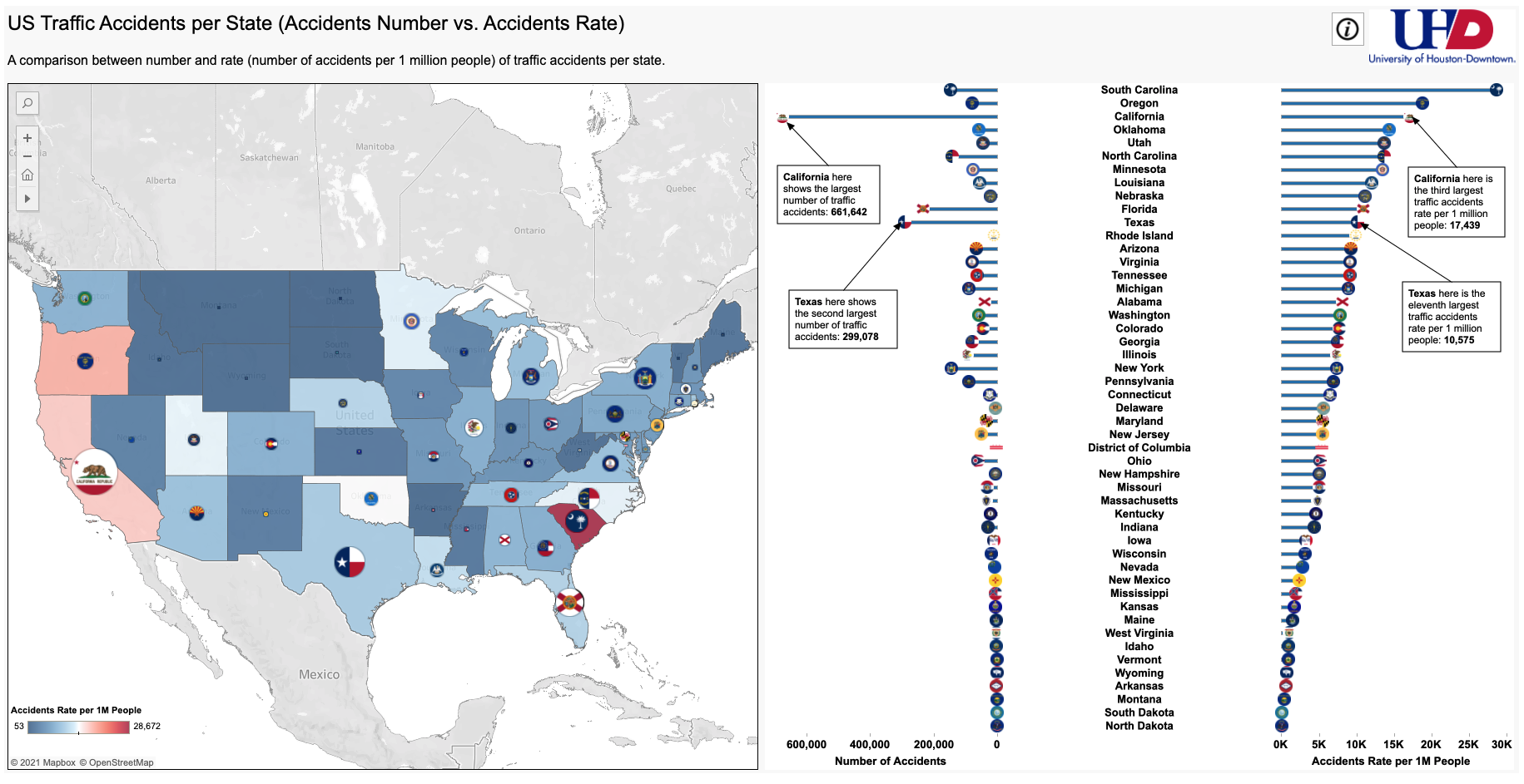
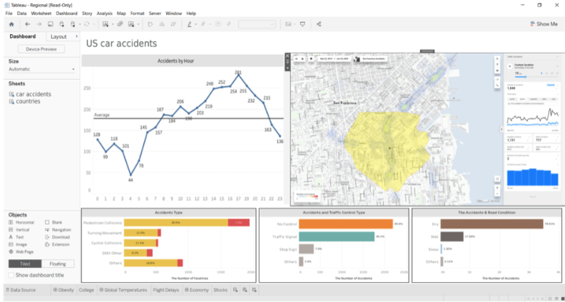
Some BI tools also have some possibility to visualize your data on a map. For example, in Tableau, we can visualize the traffic accident data set for the whole USA. With that, we know many accidents occur in each state or city. There is also a possibility to visualize the accidents as points on the map, but there are limitations to advanced work with the map.
With BI, you understand why specific (business) interactions occur, but Location Intelligence is the way to go when you need to know why they appear.
The Location Intelligence approach: Understand the context
The need for a Location Intelligence tool comes to play when the spatial relationship becomes an essential component of business success. This concerns businesses such as banks, insurance companies, retailers, and delivery services; in a nutshell, any business with its customer touchpoints, pickup points, or any other establishments.
For instance, a bank will concern itself with proximity to customers and a competitive environment in the area rather than a company that virtually offers its services. You might also want to understand other spatial factors like transportation, housing configurations, or if the location is commercial or residential, depending on how it relates to your business.
All of these insights can be easily available to you in Location Intelligence tools like CleverMaps or Carto. With LI tools, you will be able to reveal the essential spatial context for your decisions. Seeing a potential location for your new customer touchpoint or pick up point physically, in Tableau or in Google Maps is great. Still, it won’t tell you the possible customer base size, competition, POIs around a certain walking distance, catchment areas, human mobility and other essential factors.
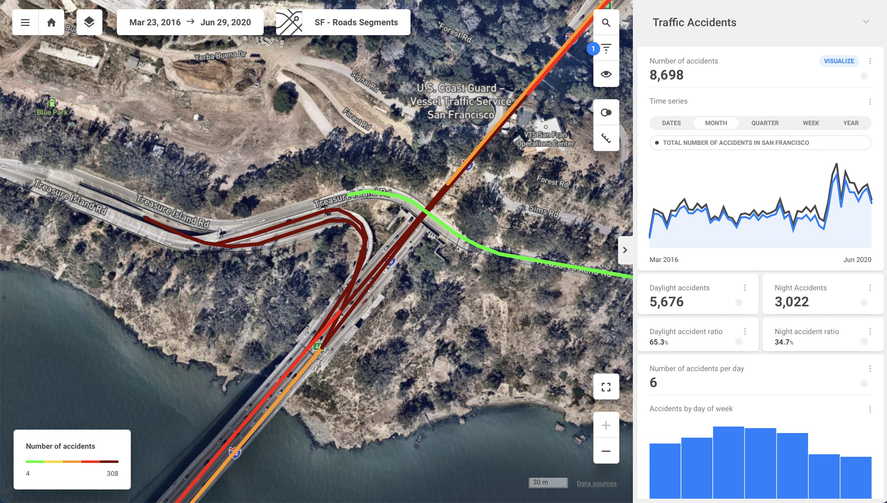
Let’s see Location Intelligence in action on our Traffic Accidents example. Some locations have more accidents than others. It might be because of a confusing intersection, wrongly placed traffic signs, or a sharp turn. These are the factors Business Intelligence won’t tell you. Using Location Intelligence will reveal the critical context for your decisions no matter if you want to prevent traffic accidents or decide where to place your new shop.

Now we know what road segments are prone to accidents, as well as what areas to focus on. Some of the Location Intelligence tools (for example, CleverMaps) allow us to discover the location even further by changing the map base layer. Thanks to this feature, we can guess what is causing the problem.
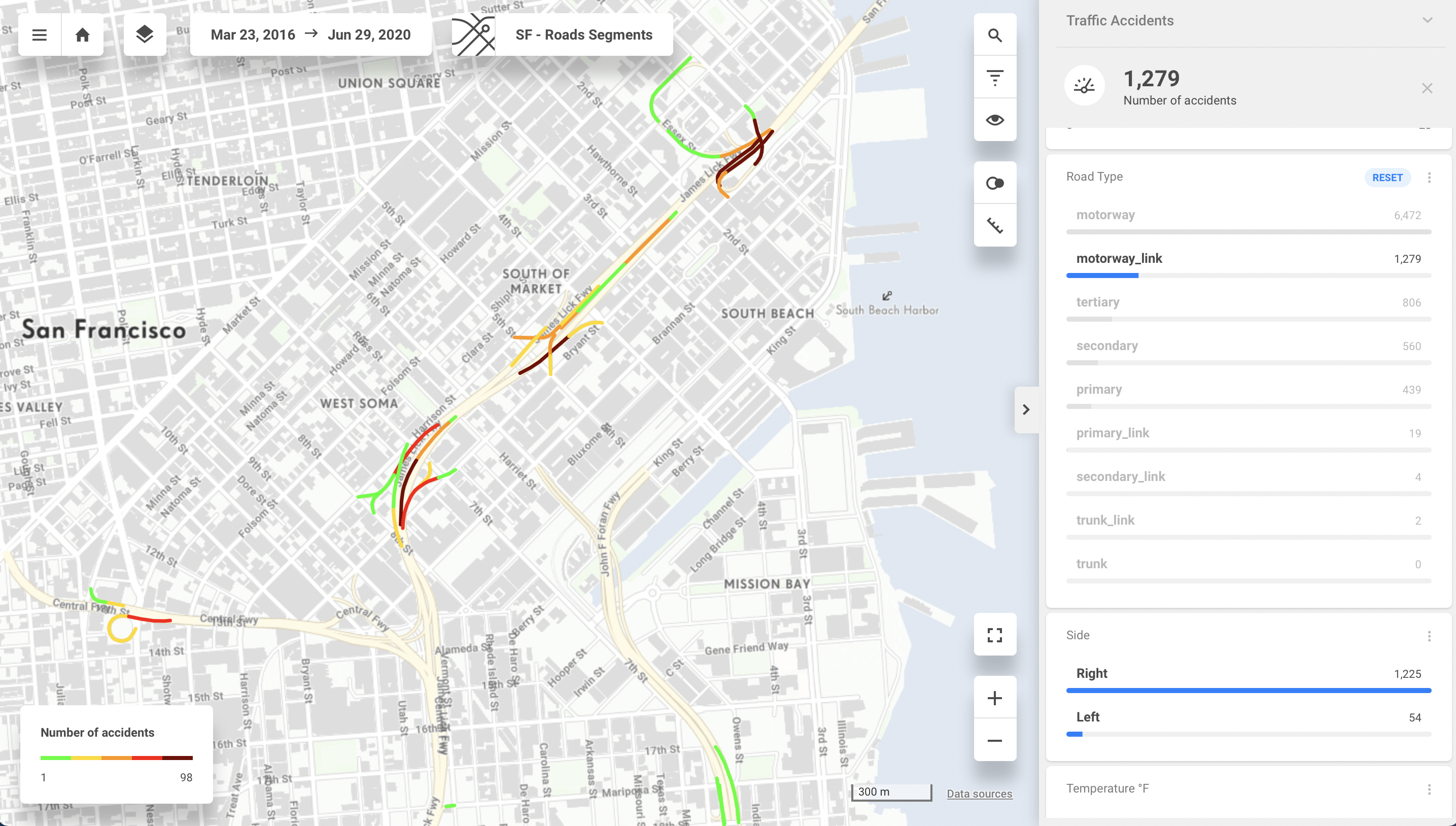
This is not where the fun ends. Location Intelligence in CleverMaps allows us to easily combine more datasets to get the context of the data. In this case, we have a dataset of the traffic accidents combined with the dataset of types of roads. Each dataset includes coordinates which are placing the accidents to concrete locations and allows us to analyse further where and why the traffic accidents are happening.
Each approach has its purpose
Well, let’s sum this up. Business Intelligence and Location Intelligence have their place in modern analytics and can be beneficial for your business. However, it is essential to remember that each of them has a difference in usage.
With Business Intelligence, you are getting all your numbers on a silver platter. You see the trends in data, and you can predict the future development based on the trends. All in a very user-friendly and graphically convenient way.
With locational Intelligence, you take things to a more spatial context. You can see what’s going on around you and how it’s impacting your business. It’s also easier to understand why you are not getting clients from specific locations, see why one of your sites is performing better than another, keep track of competition and so on. This is what could be challenging to find out in BI. With LI tools, you can narrow it down to observe locational dynamics and how it all impacts your business.
You might need one of the LI mentioned above tools integrated into your BI tool to help you uncover new grounds to cover for your Business. For example, Tableau and CleverMaps are fully compatible. With LI and BI, you’re entering a new world of analytics possibilities!


#Business


Next article

On March 12, 2021, India’s Ministry of Civil Aviation released a new set of comprehensive drone laws and regulations that apply to all Unmanned Aircraft System (UAS) registered in India, as well as to any person owning or possessing or engaged in exporting, importing, manufacturing, trading, leasing, operating, transferring or maintaining a drone(s) in India. Here, we present a breakdown of the 2021 India drone rules from the perspective of manufacturers and importers.
As per the new rules, all importers, manufacturers, traders, owners, and operators of an unmanned aircraft system will require formal ‘authorization’ certificates from the Directorate General of Civil Aviation (DGCA). Manufacturers and importers can obtain this certificate by paying a fee of INR 10,000.
Must read: India’s 2021 drone rules could be a deathblow to an already struggling industry
Prerequisites for Setting Up a Drone Business in India
- The company must be registered and have its principal place of business within India
- The Chairman and at least two-thirds of its directors must be citizens of India
As such, foreign drone companies or their majority/wholly-owned Indian subsidiaries
do not qualify to apply for ‘authorization’ and cannot own/operate drones in India legally.
Classification of Unmanned Aircraft System
The Indian Government classifies drones according to their maximum weight (including payload). There are five different categories in which UAS have been divided:
- Nano unmanned aircraft: Less than or equal to 250 grams (with its maximum speed not exceeding 15 mt/s);
- Micro unmanned aircraft: Greater than 250 grams and less than or equal to 2 kilograms;
- Small unmanned aircraft: Greater than 2 kilograms and less than or equal to 25 kilograms;
- Medium unmanned aircraft: Greater than 25 kilograms and less than or equal to 150 kilograms; and
- Large unmanned aircraft: Greater than 150 kilograms
Irrespective of the category, no drone shall be allowed to operate in India without a valid certificate of manufacture and airworthiness issued by the DGCA.
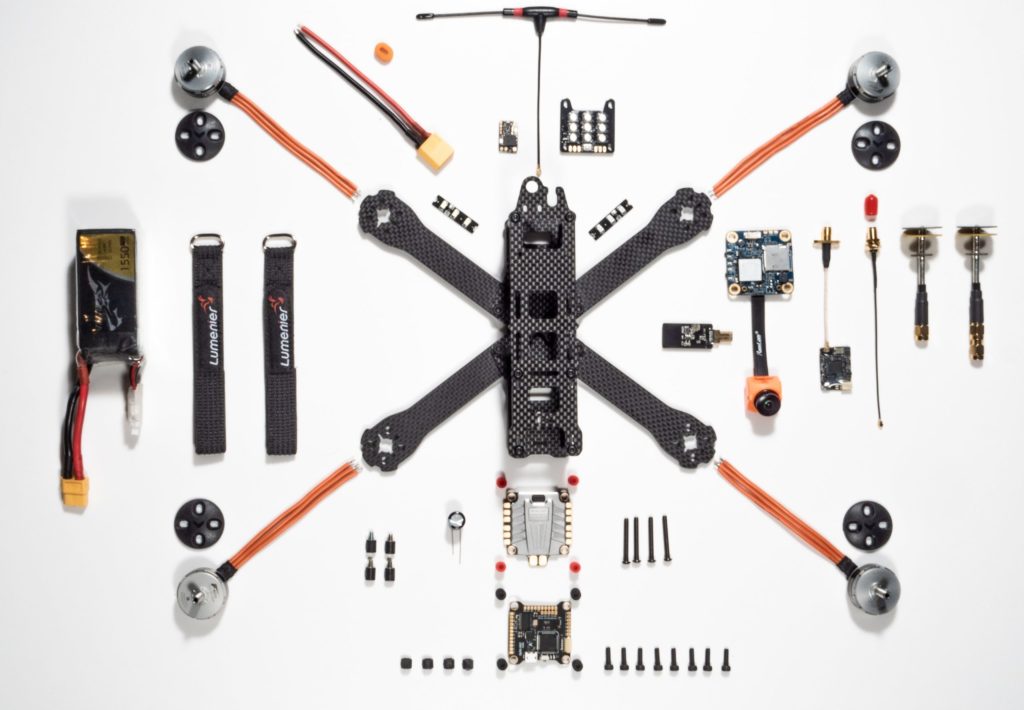
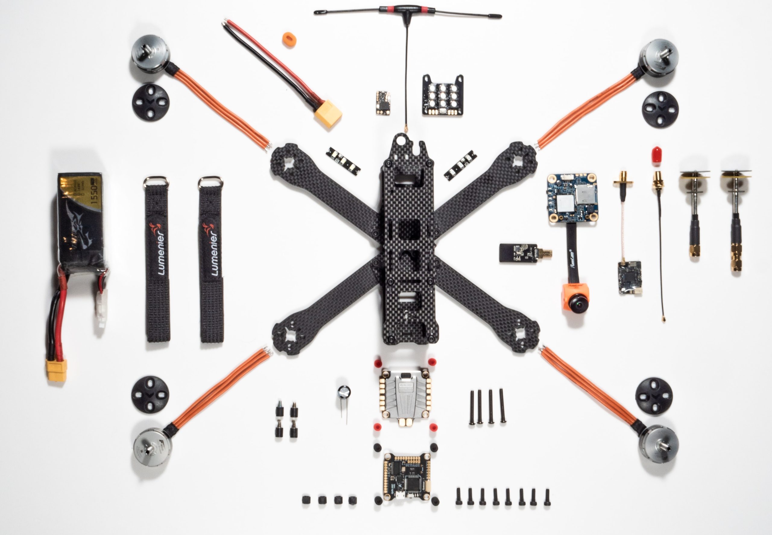
Mandatory Parts and Components for Drone Flying in India
To obtain a certificate of manufacture and airworthiness from the DGCA, every drone must be equipped with the following 16 components and features:
- Global Navigation Satellite System (GNSS) receiver(s) for horizontal and vertical position fixing;
- Autonomous Flight Termination System or Return To Home (RTH) option;
- Geo-fencing capability;
- Flashing anti-collision strobe lights;
- Flight controller;
- Flight data logging capability;
- No Permission – No Takeoff (NPNT) compliant (with tamper-proof NPNT hardware and firmware);
- Secondary Surveillance Radar (SSR) transponder or ADS-B OUT equipment (if intended to operate beyond 400 feet/120 m AGL);
- Reliable Command and Control Link;
- Real-time tracking system;
- Barometric equipment with capability for remote sub-scale setting;
- Detect and Avoid (if intended to operate beyond 400 feet/120 m AGL);
- Manufacturer Serial Number;
- Fire-resistant identification plate for engraving the UIN;
- Two-way communication system (if intended to operate beyond 400 feet/120 m AGL); and
- 360-degree collision avoidance system
Note that the Nano and Micro categories enjoy several exemptions from the above list, whereas the Small, Medium and Large unmanned aircraft further need to be equipped with an emergency recovery system to ensure protection from damage and public injury in case of any airborne failure.
Also note that it would be illegal to use a drone prototype developed for research and development purposes for any commercial applications.
Importing Drone Prototype or Drone Parts to India
No readymade drone prototype or drone parts can be imported to India without the prior permission of the DGCA. Any import of a drone prototype or drone parts will need to comply with the import regulations notified by the Directorate General of Foreign Trade. On receiving import clearance, the authorized importer will need to obtain a unique prototype unmanned aircraft system identification number and certificate of manufacture and airworthiness for the prototype UAS.
Also see: Drone flying in India: What 2021 drone rules say for pilots
How to Get Your Drone Prototype Approved
The prototype unmanned aircraft system along with its design documents will need to be tested by a government-authorized laboratory. There will be a fee applicable for this procedure. The test flights will be carried out only under the direct supervision of an appropriately-licensed remote pilot, and restricted up to a height of 15 meters in uncontrolled airspace and at least 50 meters away from uninvolved personnel.
If the test report is satisfactory, the DGCA may issue a certificate of manufacture and airworthiness for the specific type and class of drone for manufacture or import, as the case may be, to the authorized applicant.
Each compliant unmanned aircraft will be assigned a Unique Identification Number (UIN) and given a Unique Identification Certificate by the DGCA. In addition to the UIN, this certificate will spell out the category, class, model number, manufacturer’s name with a serial number, year of manufacture, and date of registration of the drone. All unmanned aircraft, except the Nano category, need to be equipped with an electronic identification based on their UIN.
Buying or selling or leasing or possessing an unregistered drone shall be illegal in India.
Drone Maintenance in India
Providing a detailed maintenance manual that specifies all the requirements and procedures for the healthy functioning of a drone is necessary. The onus to train the personnel authorized to undertake such maintenance also falls on the drone manufacturer or importer.
The drone manufacturer/importer will also need to establish authorized maintenance centers in the country and provide the details of the same to the DGCA for safety oversight.
Drone owners and operators must ensure that no drone is operated without a ‘certificate of maintenance’ issued after each maintenance, repair, or modification. Also, no drone should be operated after it has completed its life span as specified by the manufacturer.
Penalties for Unauthorized Manufacture or Import of Drones or Drone Parts
Unauthorized import of an unmanned aircraft system or part or component to India would attract a fine of INR 25,000.
A penalty of INR 50,000 would be imposed for unauthorized manufacturing of a drone or a drone component in India.
The fine for unauthorized buying or selling or leasing of a drone or drone part has been set at INR 25,000.
If you fraudulently lend out your license, certificate, authorization, permit, or approval or allow it to be used by any other person, be prepared to pay a fine of INR 50,000.
Compounding offenses for Nano, Micro, Small, Medium, and Large categories will be levied at the rate of 100, 200, 300, 400, and 500 percent, respectively.
For the complete list of 2021 drone rules and laws in India, click here.