
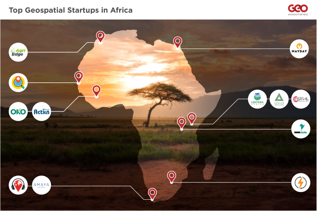
Africa. The World’s second-largest continent comprising 55 countries, covering 6% of Earth’s total surface area and 20% of its land area, more than the USA, India, China and most of Europe combined.
From Egypt in Northern Africa to South Africa in the South, and from Kenya in Eastern Africa to Senegal in Western Africa;
Not forgetting Rwanda in Central Africa, we highlight 11 start-ups using geospatial technologies to address the continent’s political, environmental and social challenges.
The names appear in order of the founding year, from the earliest to the latest.
DMM.HeHe (Hehe Labs)

🎯Software Development, Data Processing, E-commerce
📍Kigali, Rwanda
📅2010
DMM.HeHe, also known as HeHe Labs, is a mobile technologies research and innovation company founded by a group of college students. They build software technologies that help businesses optimize their operations & services.
HeHe, which means “where” in Kinyarwanda, focused on building mobile-first geolocation technologies with the vision to usher Africa into the 4th industrial revolution through building context-appropriate solutions for the continent.
Their innovative digital solutions currently serve over 2 million users across Africa.
VoiceMap
 🎯Mapping, Travel, Storytelling
📍Cape Town, South Africa
📅2014
VoiceMap uses the phones inbuilt GPS in their VoiceMap Audio Tours app to enable people to experience the magic of audio walks, cycles, drives and even boat rides in over 100 cities worldwide.
The app uses your location to play audio automatically, at exactly the right time and place. They’re like podcasts that move with you, to tell stories about what you’re seeing right now.
Insightful local storytellers, journalists, filmmakers, novelists, podcasters, and tour guides produce VoiceMap’s audio guides.
Astral Aerial
![]() 🎯Drones, Mapping, Navigation
🎯Drones, Mapping, Navigation
📍Nairobi, Kenya
📅2014
Astral Aerial Solutions, a subsidiary of Astral Aviation, is a UAV operator and service provider.
Their vision is to provide low cost, efficient and innovative UAV solutions for last-mile deliveries to remote areas in Africa.
They offer drone services for agriculture, logistics, aerial photography, aerial surveillance, reconnaissance, inspections, medical deliveries, among others.
Apollo Agriculture
 🎯Remote sensing, Analytics, Agriculture, Financial Services
📍Nairobi, Kenya
📅2016
🌐https://www.apolloagriculture.com/
Apollo Agriculture is a technology company that helps small-scale farmers maximize their profits by enabling them to access the capital and resources they need.
They address one of the fundamental challenges of improving farmer livelihoods in Africa by financing the comprehensive toolkit of inputs, agronomic training, and planting tools that underserved smallholder farmers need to increase crop yields.
Apollo assesses credit risk and customizes each package to a farmer’s specific location using satellite data, soil data, farmer behaviour data and crop yield models.
WiPo Wireless Power
 🎯Hardware, IT, Drone Technology
📍Pretoria, South Africa
📅2017
🌐https://www.wipo-wirelesspower.com/
WiPo Wireless Power cuts the power cord enabling medical devices, robotics and industrial equipment to be truly autonomous.
They provide wireless power and charging solutions for industrial and mobility devices, including drones, medical trollies, scooters, wheelchairs and other mobility devices.
Lentera Africa
 🎯Mapping, Analytics, Remote sensing, Agriculture
📍Nairobi, Kenya
📅2017
Lentera Africa is an agriculture technology company focused on enabling farmers to adapt to climate change and increase their productivity.
Lentera provides farmers with a combined package of satellite-based crop health analysis, monitoring sensors, organic fertilizers, training and soil friendly tilling equipment to enable increased farm yield and adaptation to climate change.
MAYDAY
 🎯Mapping, Automotive
📍Cairo, Egypt
📅2018
MAYDAY provides real-time on-demand roadside assistance services to motorists in need across all Egyptian cities and major highways.
Through their location-based mobile application, MAYDAY, they increase road safety by offering a wide range of services such as tow trucks, tire change, battery jump-starting and fuel delivery.
NIMA Codes
 🎯Navigation, Mapping, Location-based Services
📍Dakar, Senegal
📅2018
NIMA Codes is a telephone number-based addressing system for places without a formal street address.
The NIMA Codes app lets you sign up for a four-digit code address using your mobile phone number. You can then share the four-digit code for people to locate/ navigate to your home via the app.
AgriEdge
 🎯Analytics, Agriculture, Remote sensing
📍Ben Guerir, Morocco
📅2018
AgriEdge is a precision agriculture services platform and digital marketplace for agricultural products.
They aim to boost yields and reduce operational cost for small-large holder farmers in Africa.
The start-up employs a wide range of data, including weather data, satellite and drone imagery, to determine the required optimum level of fertilizer and water to supply each crop.
Their freemium service offers smallholder farmers and cooperatives access to yield estimates and simple crop monitoring while their premium service targets government agencies, NGOs, agri-business platforms and large-scale farmers.
Map Action
![]() 🎯Mapping, Environment, Analytics, WASH
🎯Mapping, Environment, Analytics, WASH
📍Bamako, Mali
📅2018
Map Action is a technological innovation firm specializing in the geo-localization of issues or areas of interest, mapping, monitoring and provision of databases in the fields of the environment, WASH and sustainable development.
Their tool brings together interactive mapping, geo-location and a mobile application to collect, analyze and transmit data.
The Map Action mobile app allows citizens to photograph and send environmental problems such as polluted water and waste dumping. Development partners and city authorities then rely on the information supplied by the citizens to make more informed decisions and provide rapid solutions.
Amaya Space
 🎯Space manufacturing, Remote sensing
📍Cape Town, South Africa
📅2018
🌐https://amayaspace.com/
Amaya Space is a nanosatellite-focused space manufacturing and services company with its sights set on delivering game-changing and innovative solutions.
It is a spin-out company of the vibrant satellite programme of the Cape Peninsula University of Technology (CPUT). Amaya Space commercialises the innovative nanosatellite communications solutions and complete missions developed at CPUT over the past 10 years.
Their mission is to help alleviate poverty in South Africa, eradicate unemployment, and contribute to the transformation of a new industry, ensuring equal distribution of economic gains and job opportunities.
Conclusion
The above is not a comprehensive or definitive list; there are many more geospatial start-ups in Africa.
With the recently launched African Space Policy, we expect to see more start-ups in the coming years. The African Union (AU) introduced the policy in 2019 to provide the guiding principles for a space programme that will serve the needs of the African continent.
Which Africa-based geospatial start-ups are impacting your community? Why not share them with us in the comment section below?

#Business


Next article
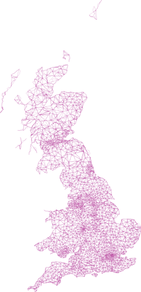

This time last year, geographer and explorer Dan Raven-Ellison called out for 100 volunteers to join him for a hack day at the Geovation Hub in London and create a network of 1,000 walking routes that connect Great Britain’s towns and cities. The ‘Slow Ways’ hack day was such a success that Raven-Ellison started planning 10 more hack days in different regions of the UK.
And that’s when COVID-19 hit, sending the nation under a lockdown. “I didn’t want the project to falter, but lockdown had led to thousands of people who loved to get outside being stuck indoors,” Raven-Ellison explains. It was time to pivot.
The former geography teacher and Ordnance Survey Get Outside Champion soon realized that rather than being done in person as part of a hack day, the Slow Ways project could instead be completed online as a citizen geography endeavor. All that was needed was OS Maps, Google Docs, Skype, and Zoom.
And sure enough, two months later, the first draft of the Slow Ways project saw 700 volunteers mapping over 7,000 routes that linked together not just the UK’s towns and the cities, but also thousands of villages. Today, 7,500 Slow Ways walking routes have been identified, stretching for over 110,000 km! Take a look:

Now, the team is busy putting together a website that would host all the routes. Raven-Ellison hopes that Slow Ways will make it easier for people to see, imagine, plan, share, and enjoy journeys on foot – and, in the process, help tackle the climate and ecological emergencies too. “We need solutions to the economic, health, ecological, and climate crises. Walking between places can not only improve our health, wellbeing, environment, and finances on a personal level, it can improve them on a societal level too.”
All Slow Ways walking routes are drafted, tested, reviewed, and verified by volunteers. And considering that 1 million people live within just 500 meters of a Slow Way, the team is excited to see how people use them to see family, meet friends, get to work, or go on adventures.
“We’re now looking for 10,000 people from across Great Britain to help walk, test, record and review all of the routes that have been drafted. In some cases, we’ll need to design new routes too,” says Raven-Ellison. If you’re up for helping, click here.