

Satellite internet is expensive. The hardware will set you back by hundreds of millions of dollars, and the cost to deliver a satellite into space is no peanuts either (though it has come down considerably in the past few years). Companies like SpaceX and OneWeb are planning to work around this by flooding our skies with inexpensive small communication satellites.
But, traditional satellites hang around 22,000 miles above the Earth in the geosynchronous orbit (GEO) and are able to cater to a large area at once. Smallsats, on the other hand, float in the low Earth orbit (LEO) – which is at a distance of around 100 to 1,250 miles – and circle the Earth every 90 minutes. Their strength lies in numbers. To swathe the entire planet with coverage, you need hundreds of smallsats operating at once in what is known as a constellation. Manufacturing and launching so many satellites takes time – lots of it.
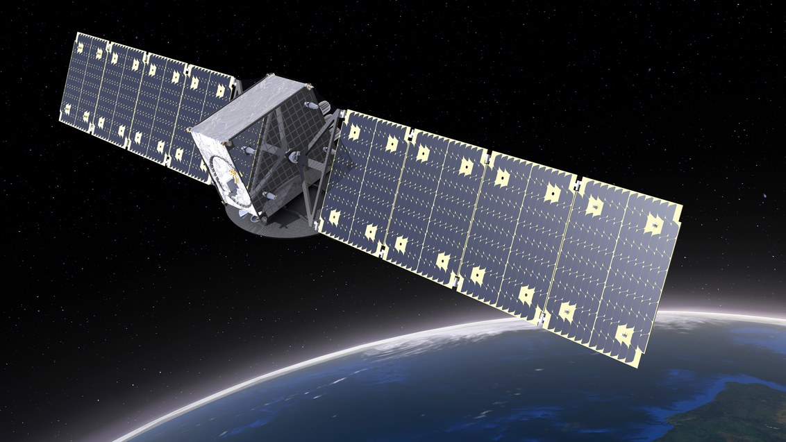
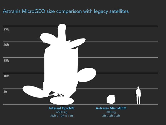
But now, a startup called Astranis has come out of stealth mode to reveal that it has developed satellites the size of a mini-fridge for the geosynchronous orbit. So, while these mini sats will have all the benefits of low hardware costs, Astranis wouldn’t be burdened with launching hundreds of them just to become operational. The startup is convinced that this combination will allow it to offer satellite internet to users at the price of cellular data.
 Last week, the company received a vote of confidence in the form of a $13.5 million funding round from venture-capital firm Andreessen Horowitz. “[Astranis] has put together the right technology and strategy to offer broadband connectivity anywhere on earth at a small fraction of what’s possible using traditional satellites,” Andreessen Horowitz says in a blog post.
With its initial designs, Astranis has achieved a bandwidth capacity of 10 Gbps per spacecraft. And the team says that it has a technology roadmap that can significantly increase that speed in future spacecraft designs. The startup plans to launch its first commercial satellite in 2019.
That said, the price tag is not the only reason why most of us are getting internet through a fully terrestrial connection. The other major issue with satellite internet is that of latency – it takes much longer for communication signals to travel to a satellite and back than it takes to travel through fiber optic cables. This means there is a considerable time lag between when information is requested and when it is received.
To that, Astranis explains, “What we found in studying this problem for a long time was that 95% of internet traffic isn’t latency sensitive — CDN traffic, video streaming, audio streaming, file downloads, social media posts, etc. The bandwidth crunch is a huge problem to solve but we realized there is low-hanging fruit here that we can go after by putting satellites one at a time in GEO and putting a dent in it immediately, vs LEO constellations where you have to put up hundreds of satellites (at a cost of billions of dollars) just to get started.”
The thing is, we simply are not able to get fiber optic cables everywhere. Areas like the Pacific Islands chain depend solely on satellite internet. There are 4 billion people in the world who are still deprived of access to the internet. So, latency doesn’t really seem like a bad trade-off. What do you think?

#Business


Next article
Director Denis Villeneuve’s Blade Runner 2049 may not have set the box office ablaze, but the film is nothing short of a visual feast. Be it the uncanny attention to detail or the incredible care with which it colligates buildings and locations in a dystopian world, the movie’s spectacular VFX ensured that the sequel to 1982’s contemporary classic Blade Runner will take home the Oscar for Achievement in Visual Effects at the 90th Academy Awards.
But did you know that it was a geospatial application by Esri that gave Blade Runner 2049 its mesmerizing visuals? Framestore, a visual arts studio based in Canada, recreated the city of Las Vegas, Nevada using Esri’s CityEngine 3D modeling software.
By using CityEngine for only a month, the designers at Framestore were able to generate a 6.759km long and 4km-wide production set with more than 1,400 buildings. According to Esri Canada, the visual artists used this model as the base and retained some of the most recognizable structures of Las Vegas in the dystopian world. So, you can see Caesar’s Palace and the MGM Grand sign when K (Ryan Gosling) goes to meet Rick Deckard (Harrison Ford).
In an interview with TechRepublic, Richard Hoover, VFX supervisor at Framestore, details, “It was an incredibly complicated landscape, with an enormous amount of geometry and items, human scale items that we built to reinforce the scale. The Syd Mead buildings that we added were enormous scale so we needed something that people could relate to, because there’s nobody in the city, everybody’s gone. There were very [few] automobiles or anything to identify how big things are, so that was the biggest design struggle with selling the scene and making it look real.”
The team used aerial and oblique photos of the present-day Las Vegas main strip to give the futuristic version of the city realistic textures. CityEngine converted 2D data into 3D data and enabled the designers to play around with various elements and create spectacular visuals.
Interestingly, CityEngine is the same software which was used by the team of Zootopia –last year’s Oscar winner for Best Animated Feature Film. How geoawesome is that!?