
The data available to telecommunication operators (aka MNOs) can be very useful. One of the areas for which the data can be uniquely beneficial is population analytics – the movement & habits of populations in the world around us. That is, partially, because of the ubiquity of mobile phones, and partially, because of the extent of existing telecommunication infrastructure. The data contains insight into where each device connected from and how it moved around. And what is lacks in the precision of e.g. GPS, telco data makes up in the sample size and unique national coverage.
This has remarkable implications for use across sectors. The data can be used for international development or to inform the tourism industry. It can help monitor an outbreak of a disease or plausibly determine the number of people at a protest rally. Another example of telco data used for the public good is to optimize a transportation network between several cities by reliably determining population flows and establishing how many people work and/or have their sleeping location in a given city.
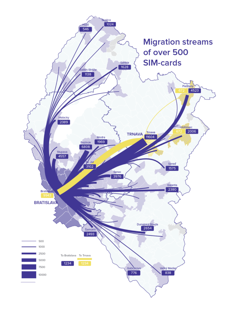
The practical example comes from Slovakia. A big data scale-up Instarea teamed up with Slovakia’s top 3 telco providers (Slovak Telekom, Orange, O2) and the Comenius University (Peter Barlík and Martin Šveda) to provide the Bratislava Integrated Transport (BID) an analysis of commuter patterns in two western-most Slovak regions. The point was to map out the scale and intensity of spatial interactions amongst towns & cities of the region. Or simply, where people live and where do they travel for work.
What do the phones show?
Officially (according to permanent residency statistics), approximately 422,000 people reside in the capital city Bratislava. This number, however, has been long believed to be very unreliable. Bureaucracy and inconvenience cause that many people who live in Bratislava do not register their permanent residence. (In Slovakia, you would need a new ID card every time you move, because it also contains an address. So, residents simply don’t do it.) The city officials knew about this issue but until recently had very few choices than to rely on the official numbers.
50% more people
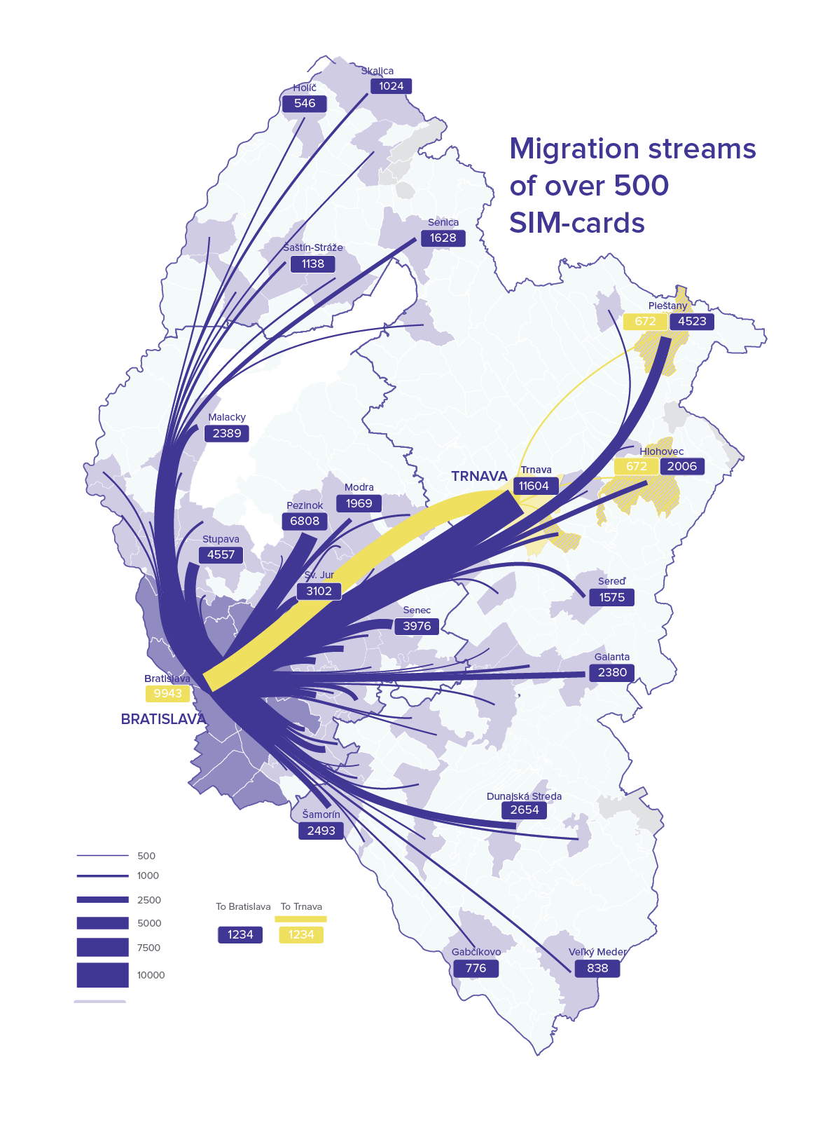
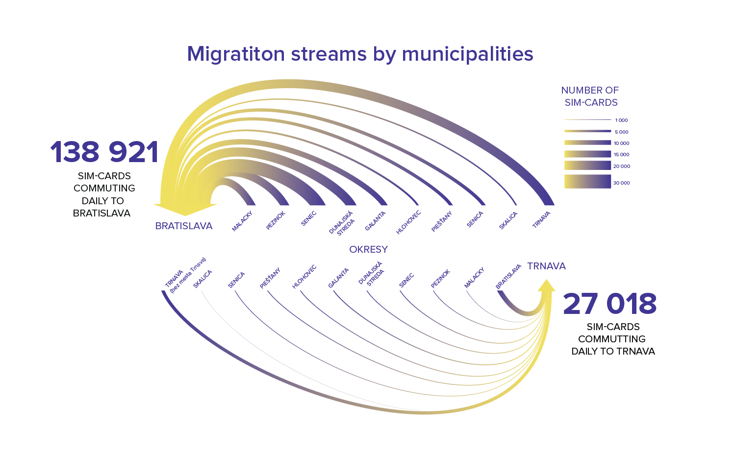
The analysis unearthed a surprising number. According to the telco data, there are at least 633,000 SIM-cards with a sleeping location in Bratislava. Already an over 200,000 difference in the number of inhabitants. Now, this is a sleeping location. What if you count in another over 139,000 SIM-cards which commute to Bratislava for work daily (this is somewhat balanced out by approx. What if you count in another over 139,000 SIM-cards which commute to Bratislava for work daily (the number will be notably larger because the data were collected only from two regions, but there are people commuting daily from Austria, Hungary and two other Slovak regions). And then, we should not forget about the tourists of whom there are tens of thousands on any given day (and are not represented in the data). Turns out, Bratislava is a significantly larger city than it might be apparent when you look at the official statistics.
The 100 million EUR gap
This is quite a bit more significant than it might seem at first glance. One hundred million euro more significant, to be precise. In Slovakia, money is distributed to municipalities by the number of residents and the difference of 200,000 people goes a long way. The first step was to get the insight and now city officials can focus on policies. These can include changing a parking policy (so that people with permanent residence have cheaper parking) or simplifying the process of changing permanent residence.
Sure, SIM-cards are not people. Most people do have a phone, but some phones have two SIM-cards or some people have two phones. The authors of the study acknowledge this limitation, but argue that when you adjust for the people without phones, such as many children and some elderly the number is about right (as has been shown in some previous studies). Also, the study contained data only for Slovak SIMs, not foreign ones of tourists.
Inter-regional commuter patterns
Another use of the analysis is an unprecedented understanding of the migration within and between the regions. It would have been very difficult to get reliable information about working and sleeping locations, together with routes taken by any other way. The gathered data will be used as a tool for extending the Integrated transport system in the Bratislava region (IDS BK) to neighboring Trnava region. The mobility analysis also showed that 64,000 inhabitants of Trnava region travel to Bratislava city on a daily basis and, on the other hand, 49,000 Bratislava city residents travel to Trnava region every day. This is important because train and bus transportation is preferable to the car on the regions congested roads. But, people cannot take a bus or a train if convenient links are missing. It is thus vital to understand travel patterns and to make informed decisions in routing, timetables, capacity planning and pricing.
Data insights from telecommunication companies are remarkably useful. Aggregated data is no threat to privacy and is a valuable source of information. The information that can make our lives easier, policies more responsive and the funds allocated by need. What needs more work and thought are proper frameworks to compensate the telcos for the data as well as adjust regulatory policy to make such public-good use of data easier.


#Business


Next article

The United States National Geospatial-Intelligence Agency uses its technology for 3D visualization of Map of the World. Internet browser Mozilla leverages the platform to impart real-world 3D data to its mixed reality web framework. The Toyota Research Institute creates dynamic driving simulations using their technology stack to visualize the 3D data captured by autonomous cars. And every Christmas Eve, the North American Aerospace Defense Command (NORAD) showcases Santa’s magical journey on a 3D globe using their resources.

Cesium, a comprehensive platform for 3D geospatial data, began as an internal project in 2011 at American software company Analytical Graphics Inc. (AGI). Today, it is being launched as an independent company in Philadelphia with a $5 million Series A funding to fuel its growth.
Patrick Cozzi, Cesium’s creator and CEO of the AGI spinout, is a known name in the fields of 3D graphics and geospatial technologies. He recognizes the new opportunities which are emerging in nearly every industry because of the wealth of real-world 3D data being collected by LiDAR sensors mounted on satellites, aircraft, drones, cars, and IoT devices.
Add open data policies, crowdsourcing, and AI-generated semantics to the mix and you get high-resolution 3D geospatial data that is more easily available and more frequently refreshed than ever before. “This data needs to be made accessible, shareable, and ultimately usable. This is where Cesium comes in,” Cozzi explains.
By unlocking the potential of real-world 3D data, Cesium empowers developers to easily build 3D data into their apps. The platform allows data providers to share massive datasets like terrain, photogrammetry, and point clouds in seconds with just a link, and turn them into realistic visualizations to glean insights from them.
At the heart of Cesium’s platform are 3D tiling pipelines which transform 3D data into streamable content for both online and offline devices. Cesium is also the creator of 3D Tiles, an open-source visualization engine that got adopted as a community standard by the Open Geospatial Consortium earlier this year.
As Cozzi says, “Whether you are building digital twins for smart cities, AI-powered drone data capture platforms, or mixed reality mission planning for the military, we are designing Cesium — and the ecosystem it enables — to be the foundation on which you can realize your vision with 3D geospatial data. We can’t wait to see where you take it.”