
Holidays can be stressful. There is so much planning and preparation, gift shopping, partying and travelling involved that this season can take a toll on mental and physical health alike. And nothing kills the joy of a Thanksgiving road trip more than getting stuck in the holiday traffic. For me, these visuals of Los Angeles’ traffic nightmare are scarier than The Haunting of Hill House:
#MannequinChallenge? Traffic nearly at a standstill on the 405 Freeway https://t.co/yfahcIv8AR pic.twitter.com/ZQndXJwEA3
— ABC7 Eyewitness News (@ABC7) November 23, 2016
So, how can Google Maps help?
Understand Traffic Patterns
You may know your area’s traffic patterns during a normal week, but holidaymakers follow a schedule of their own – with the day before Thanksgiving between 3-4pm being the worst time to hit the road. This handy chart by Google tells when you can expect traffic to be heavier than normal in your area:
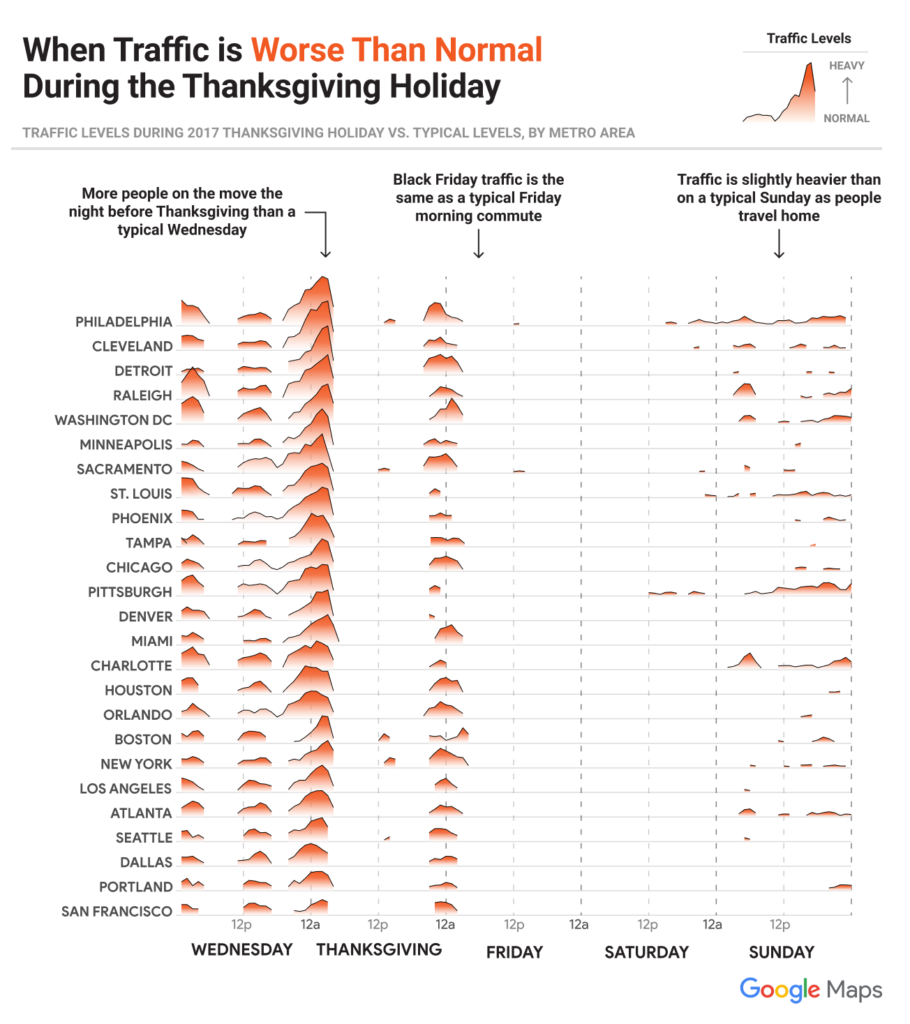
You can see it’s best to avoid the Friday/Sunday afternoon rush and leave in the morning instead, after Thanksgiving.
Avoid the Crowds
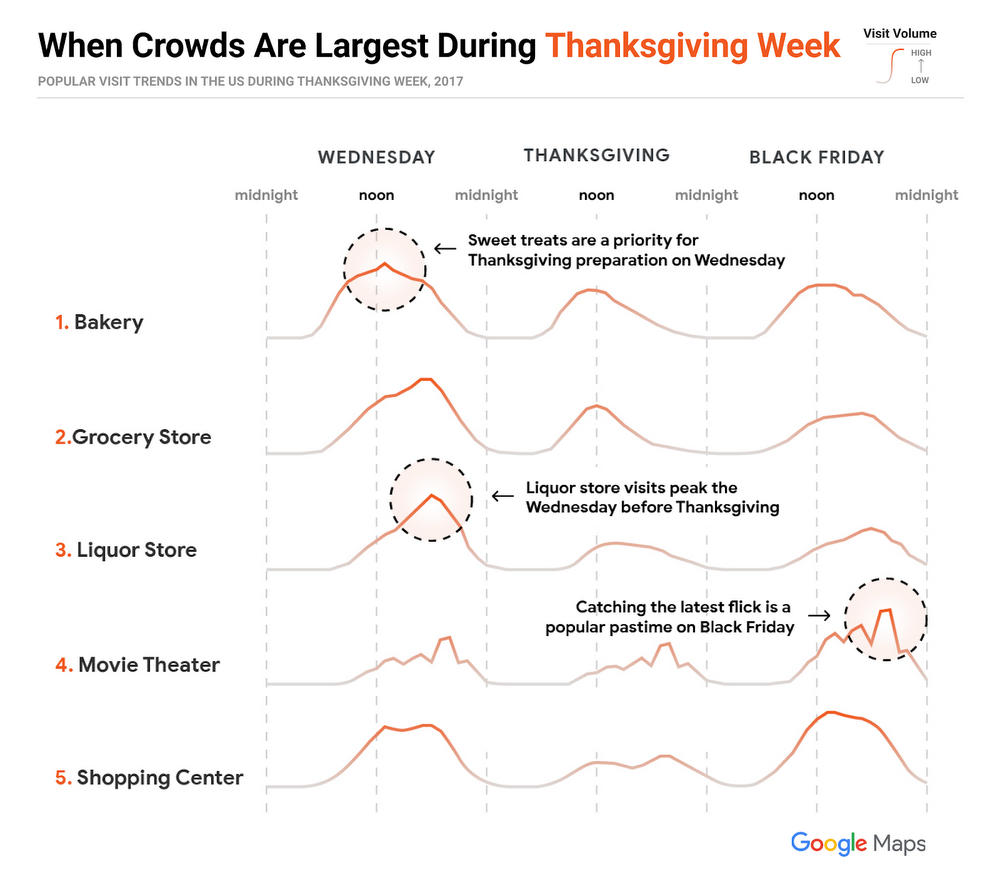
If you don’t want to waste your afternoon being stuck in a queue at the grocery store, shopping mall, the local bakery, movie theatre, or the liquor store, use this chart to see when you will be able to avoid the crowds at popular places:
Route Search
If you just remembered that Aunt Margaret had asked you to bring some avocados or realized that you’re running out of gas, don’t worry. Simply search along your route on Google Maps and find the nearest place you’re looking for without taking a massive detour.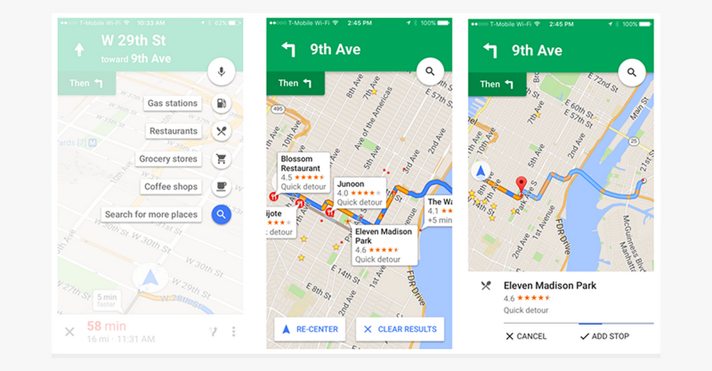
Share Your ETA
There’s no fun in keeping the family guessing. In its latest update, Google Maps has made its journey sharing feature even better, so you can let the fam know what time you’ll be arriving without needing to make a call or send a text. Simply tap on the ˄ button once you have started the navigation and click ‘Share trip progress.’ You will not only be able to provide your live location to your loved ones, your route information and ETA will also be shared.
If you found the post interesting, head on to this interactive site put together by Google Maps for more insights on Thanksgiving traffic and search trends in your state.

#Business


Next article

Users of large volumes of geospatial data are currently challenged. With Copernicus, Europe’s flagship Earth Observation programme directed by the European Commission, there has never been more environmental information openly available. The new climate reanalysis product ERA5 from the Copernicus Climate Change Service for example is expected to have a total volume of 5 PB alone. This wealth of information brings new opportunities for detailed global environmental analyses or long-term time series analyses. At the same time, with the verge of cloud services, unprecedented processing capabilities arise. Cloud services may offer data storage, data access and data processing in one place, allowing data users to fully concentrate on the data analysis rather than data download or data preparation.

The new wealth of information, that allows for analyses that were impossible before, brings along new challenges. Challenges arise for data providers and providers of data services. The scope of current data services ranges from traditional download services up to new cloud-based processing platforms, such as the Google Earth Engine or the Copernicus Climate Data Store.
As diverse as the many available data services are, the diverse are the user groups of Big Earth Data. The term Big Earth Data in this context refers to digital information about Earth, including observations, imagery, derived higher-level products, forecasts and analyses produced by computer models. The group of climate data for example contains a wide range of scientists (meteorology, climatology, hydrology, ecology, but also social sciences), decision-makers, resource managers and public health officials, but also start-ups, established companies in the insurance and energy sector. User groups whose knowledge on the data itself and technical expertise vary.
Traditional data download services are not bearable anymore
The fact is: with the current and expected Petabytes of Big Earth Data, traditional download services are not bearable anymore, for data centers and data users alike. Future data services will most likely rely on cloud services. However, there are still many questions how these future data services can look like. For example:
- would users trust a cloud-based service,
- would users like to have data access and processing combined with available processing tools,
- would users pay for cloud-based processing and if yes, how much are they willing to pay,
- how do users interact with the data at the moment and how would they like to interact in the future,
- what processing tools do users use and
- what data formats do they prefer?
A user requirements survey on Big Earth Data aims to better understand the above questions. Users of large volumes of environmental data, e.g. satellite images or meteorological fields, are invited to participate to the survey.
Users of geospatial data in the spotlight – Have your say
The survey aims to find out how users interact with Big Earth Data and what challenges they face due to the increase of data volume. One section deals with future data services and cloud services. It aims to find out how users would like to interact with cloud-based data services and what requirements needs to be fulfilled in order to have the trust of data users.
By participating to the survey, you help to indicate the direction and evolvement of future data services.
The survey is part of a PhD thesis on “Big data technologies for meteorological and climate data” at the University of Marburg, Germany, in collaboration with the data services team of the European Centre for Medium-Range Weather Forecasts (ECMWF). ECMWF is an intergovernmental organisation and both, a research institute and a 24/7 operational service, producing global numerical weather predictions and other data for its member and cooperating states and the broader community. ECMWF runs two out of six Copernicus Services, the Climate Change and Atmosphere Monitoring Service. Both services produce environmental information on climate (e.g. climate reanalysis data or seasonal forecasts) and the atmosphere (e.g. Ozone and parameters to measure air quality, e.g. nitrogen oxides).
Participants can indicate whether they are interested in the results of the survey. The results of the survey will be published next year.
The survey will be open until 30 January 2019. It should not take longer than 10 minutes to fill out.