
This post has been cross-posted from HOT News.
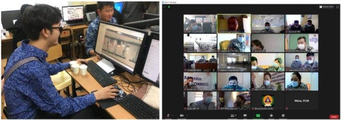
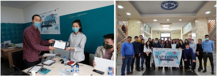
Amid the Covid-19 pandemic, a diverse group of individuals representing the 21 provinces of Mongolia came together to support the Covid-19 response in Mongolia, organized by Public Lab Mongolia (PLM), a local non-governmental organization. PLM’s long-term, core program, Mapathon, brought together individuals to map health and essential services in their own communities to contribute to Mongolia’s effort in managing the pandemic as part of the “Covid-19 Community Mappers Program.”
PLM’s Mapathon program is intended to promote a culture of open-data, raise awareness and build capacity for geodata creation and use, and support data-based decision-making. Mapathon is unique in that anyone can actively participate as a contributor to open-source data creation.
By crowd-sourcing data using open-source technology, PLM hopes to make data accessible to key stakeholders such as civil society, local government agencies, researchers, and reporters.
As local community mappers, the 21 program participants learned how to use and make data contributions to OpenStreetMap through hands-on training by PLM. The community mappers then mapped all the health and essential services in the 21 provinces and 330 soums (counties) of the country. The data mapped included a total of 1,651 health services, 595 water kiosks, 2,065 grocery stores, 970km of highway, and 27,077 other services such as public bathhouses, petrol stations, schools & kindergarten, banks & ATMs, bus, taxi, and train stations.
The Covid-19 Community Mappers Program made a tangible, community-driven contribution to supporting the country’s pandemic response. OpenStreetMap serves as one of the key sources of available geodata in the country for key national agencies managing the pandemic response. Also, the data will remain open to all, continuing to serve many other positive local developments such as delivery services, tourism, and service planning and provisioning.
The rural community mappers from the 21 provinces highlighted the positive impact they were able to make in their own communities. As one of the community mappers said, “I plan on continuing to work on my province until [it is] completely mapped, and I think of it as my personal contribution to my province.” The program also brought people together; as another community mapper said, “I think we all realized and saw [that] the possibilities of working as a team on something important, even remotely, are boundless.”
PLM believes that this program of rural community mappers has been an exemplary case on how to foster civic engagement and enable everyday citizens to become leaders in their own communities through open access resources. As another mapper stated, “This program has been not only very productive for society, but also a great opportunity for personal and professional development.” Civic engagement in open geodata creation and use can be a powerful and engaging way for data-based, community-driven advocacy to improve lives and support democratic and informed community development.
Update: PLM is planning to organize a YouthMappers 2021 program with local universities and government organizations across Mongolia, training a generation of citizens and decision-makers who will be versed in creating and using geodata.


#Business


Next article

I remember getting a demo of some new high resolution aerial imagery a few years ago. The person giving the demo zoomed down into someone’s backyard to the point where I was able to see a plastic fork on a paper plate left on a picnic table.
And not just the rough shape of the fork, but its delicate little teeth! From the sky! Someone had just been nibbling cake, it would appear, from the crumbs that were also visible.
As the demoer described how this imagery could be used to help property assessors make faster, easier, more accurate assessments my brain deviated from the script and zoomed out to the big picture. Surely this is about more than taxing people better, even if that is an immediate and valid business case.
My thoughts drifted back to art school and reading about Marshall McLuhan who theorized that every new medium first imitates the content of a medium that preceded it. Or something like that. When you first invent the motion picture camera you think, “How can I film a stage play?” Eventually you realize you can do completely new and different things with the technology, and culture changes.
Those of us who develop and sell geospatial data and services are very familiar with helping existing processes happen faster, easier, and more accurately. We often supercharge stage plays with known scripts. It’s what customers pay for right now, and so, accordingly, we focus in that direction.
At the same time I think that many of us also have a creeping feeling that something big is changing, and that helping people do the things we already do “faster, easier, and more accurately” will begin to flip over into doing things differently, with a different awareness of what the powers and responsibilities of our industry are.
The reason why this will happen is that the geospatial world is just getting too good, too high-resolution, too intimate, too powerful, and too pervasive to believe it’s about improving all the things we did when there was very little light in the room.
The lights aren’t blinding yet, but they are rapidly brightening with no indication of slowing down. The world which was once largely unknowable is now a 25,000-mile-around ball that we surveil at greater and greater resolution and frequency each year. Algorithms scour the entirety of its surface to make sense of what’s on it. Billions of people wander the globe with location-aware devices, taking pictures and video, talking, noting their sentiments, and drawing a live social graph as profiles of each of them are created and connected. Government databases and facts are flowing into the mix. Everything is getting appended together. Many companies chase the dream of being the one that somehow owns all of this.
But when we can see all the plastic forks on all the paper plates all the time everywhere, and the plates can be matched to people and things and facts around them, and algorithms constantly crunch it all for insights, correlations, and predictions, then pantomiming the past and doing what we’ve always done will feel silly to the point of farce.
Geospatial data will more fully enter the world of community and political conversation where it’s role in society will be discussed, redirected, and reshaped.
I’ll give you a brief example of something I know from our home base in Detroit. For more than a decade there has been an out of control tax foreclosure problem. Tens of thousands of primarily Black Detroiters lost their homes due to overassessed property taxes, lack of access to available programs, usurious interest rates, and lack of prompt action. The geospatial data is there to show this, and it has been publicized, but the stage play still plows forward, trying to identify the vacant homes for demolition or to sell them to new people, without a concept of reparation, justice, or healing it could have.
When I squint at the future, I see something similar coming for the geospatial world as is currently happening to the Big Tech companies who are being scrutinized for the power they have over people’s lives, what happens to people’s data, who chooses what information people see, how to stop bad actors, and so on.
There will be questions about the impact of geospatial data and the geospatial industry on the economy, privacy, racism, bias, equal opportunity, environmental health, sustainability, and every pressing issue we currently debate through other lenses.
Who is using the data? Where does it come from? Why do only some people have some of it? Why does *anyone* have some of it? What kind of algorithms are being run on the data to make decisions? What are their biases and financial incentives to change the landscape in one way or another? How is that affecting people’s lives and the environment?
There will be questions about who in the geospatial world may have a Monopoly on certain services or datasets that should be opened up or regulated.
How will it all play out? Hey, man, I just work here, but it feels like something different is getting pretty close. Maybe not this year or next year, and maybe it will continue to be a slow change without clear definition, but as things progress it’s always a thought in the back of my mind that we’re an event or two away from a noticeable change in the landscape.
Accordingly I try to adopt a posture within the industry that allows us to deliver “faster, easier, more accurate,” while retaining an open heart and open mind with the flexibility and humbleness to evolve, and to help others do so as well.
Not to speak for that little fork, but those are some thoughts on the mind from here in spring 2021.