
The idea of using high accuracy GPS/GNSS Geodetic receivers as Earthquake sensors has been around for a while now. The fact that these high accuracy receivers can detect and measure ground displacement in the order of a few millimeters makes them good candidates for an Earthquake early warning system. (Reference: Application of real-time GPS to earthquake early warning in subduction and strike-slip environments). There are only so many GPS/GNSS permanent observatories in the world but most smartphones these days have a GPS/GNSS sensor onboard although their inaccuracies leave much to be desired for such scientific applications.
However, a group of scientists published a paper titled “Crowdsourced earthquake early warning“ on April 10th, 2015 suggesting that GPS found in Smartphones could give a good indication of seismic activity. They believe Crowdsourced GPS/GNSS data could essentially work together with existing systems to help fill the data gap with Earthquake Early Warning networks.

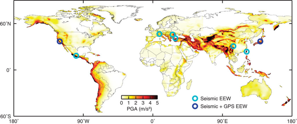
Global seismic hazard and extent of EEW. Symbols show the few regions of the world where public citizens and organizations currently receive earthquake warnings and the types of data used to generate those warnings (7). Background color is peak ground acceleration with 10% probability of exceedance in 50 years from the Global Seismic Hazard Assessment Program. (Reference: Minson, et.al)
Earthquake Early Warning Systems
Earthquake Early Warning Systems are designed to pick up the first tremors of a Earthquake in a region and provide a warning to citizens and National agencies based on computations about where the Earthquake is centered and how strong its likely to be. In countries that are economically sound, such a network is realized with the help of expensive seismograph-based system but not everyone can afford one, maybe Smartphones could fill that gap.
Can Smartphones really be used as Earthquake Early Warning Sensor?
Smartphones of today have the essential sensors that you would find in a decent Earthquake sensor i.e a GPS/GNSS sensor and accelerometer. Of course, their accuracy is at the least worse by a few orders of magnitude in comparison to an expensive Geodetic receiver/Seismograph but the hope is what they lack in accuracy, they will be able to compensate with quantity.
If you are wondering how they differentiated between shifts due to seismic activity and regular phone movements, the answer lies in Crowdsourced measurements. The ubiquitous nature of smartphones helped the researchers separate normal movements from an actual tremor just by correlating the motion with similar movements in nearby phones.
Assuming that such a system is in place and Crowdsourced GPS/GNSS data is being gathered using an app, there are two fundamental issues that the researchers had to consider
- The number of users that would be actively reporting GPS/GNSS data at any given point of time is going to be a small fraction of the total user base, thanks to the power hungry habits of GPS sensors and privacy concerns surrounding location data.
- Such an application would need the raw GPS/GNSS measurements and not the smoothed outputs the mobile operating systems be it Android or iOS provide.
How close are we, then, to operational crowdsourced Earthquake Early Warning system?
To quote the authors of the paper,
As we have shown, current smartphones could be used immediately to provide warnings for the largest earthquakes, such as those associated with subduction zones, worldwide. Additionally, because of the enormous number of potentially available devices, a crowdsourced approach could be very conservative in terms of data quality control (for example, excluding devices with poor sky view or subject to unwanted accelerations such as from automobile usage) without sacrificing performance. – Minson, et.al
More often that not, we see only commercial applications for Location data. It’s refreshing to note that crowdsourced location data (GPS/GNSS to be precise) can help save lives.
Science has found a use for the Internet of Things, where any GPS-enabled device could help crowdsource seismic activity and save lives – Vocativ
Crowdsourcing & Scientific Research
Crowdsourcing is an important phenomenon that has only begun to be used across the sciences and must be considered seriously. Given the long repeat times between earthquakes and tsunamis and limited budgets with which to take preventive measures, crowdsourcing may be an important part of building, maintaining, and operating warning systems. – Minson, et.al
What next?
The researchers have already planned a pilot study in Chile, where they plan to build an Earthquake Early Warning system using commercially available phones equipped with an external GPS chip (to circumvent the operating system issue). It is to be noted that Chile doesn’t have an Early warning system and considering that each phone is only going to be used for Earthquake sensing, the researchers hope most of the intermediate challenges would be solved and the results could be good.
But even in the short term, Brooks says, crowdsourced early detection does not necessarily have to stop at smartphones. “It’s about the Internet of Things, really. Cars, robotic vehicles, WiFi hubs—anything that has GPS associated with it could be used.” Vocativ
Interested in reading the full paper, here’s the link.


#


Next article

“The Sky is the limit only for those who aren’t afraid to fly!” ― Bob Bello
They say that our ancestors and the ones before them, have always wanted to take flight and reach for the moon! It has been a few million years since the first humans appeared on the surface of this wonderful planet and they all dreamt of taking flight and going to space and for thousands of years that dream remain elusive and too futuristic. Although mankind progressed from a hunter-gatherer to a sophisticated species capable of building cities, the space remained elusive. Never has a dream united mankind like our elusive dream to conquer space has!
That dream remained elusive and impossible until Sergie Korolev and his team launched Yuri Gagarin to Space. A race to space that was being played out across two continents by two men – Sergie Korolev and Dr. Von Braun. It’s hard to comprehend an achievement of this magnitude; think about it – Humans have dreamt of going to Space for at least thousands of years and now it has become something routine with the International Space Station. The more you think about it, the more overawed you feel about our Space program!

The International Human Space Flight Day (Cosmonaut Day in Russia) is held on April 12th each year to celebrate the biggest achievement of mankind.
Here’s wishing all success to future space mission and for greater cooperation between nations and men! To outer space and beyond! Godspeed…