
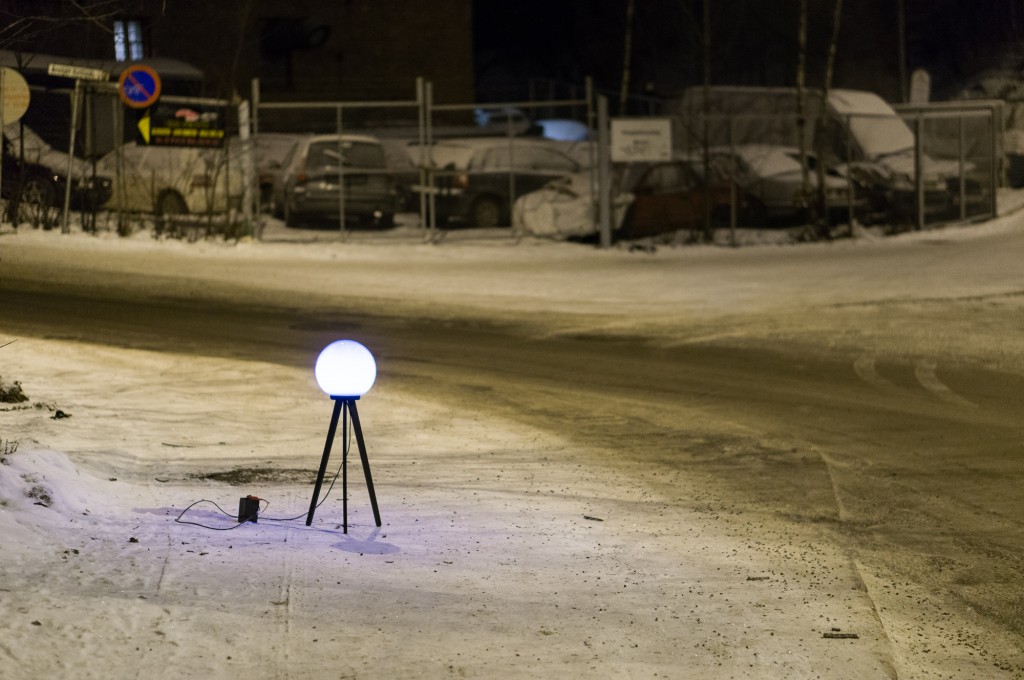
Recently we came across an interesting artistic projected called Satellite Lamp. The artist Timo Arnall placed around Oslo, Norway 50 GPS equipped lamps which change brightness according to the accuracy of received GPS signals. Than he photographed them as time-lapse films in order to start to build a picture of how these signals behave in actual urban spaces.
The project investigates what Timo describes as “one of the most important, yet completely normalized, modern infrastructures.” And in fact that’s true. How many of your mortal, spatially unaware friends understand GNSS technology? They seamlessly use it everyday but they don’t really understand how it works.
Everyday city life is being shaped by the technologies and devices in our pockets, creating new social and spatial practices. These products are made possible by vast technical infrastructures and complex systems that we rarely see and that we often know very little about. GPS is a good example of how these systems are often invisible, often obscure or go unseen, and are becoming increasingly mundane.
The main outcome of the project is the video:
Totally Geoawesome!

#Business

Next article

 GIS Cloud is opening 2015 by taking the “Simple GIS” idea even further and announcing the release of its Partners Program. The company is looking for partners worldwide that are ready to resell, integrate and customize GIS Cloud into their local markets and industries.
Register for a free webinar on Wednesday, January 21st, where the Partners Program will be discussed in detail.
BENEFITS OF PARTNERING WITH GIS CLOUD
Apps and maps need to be easy and simple with an emphasis on collaboration and high user experience, so that any role in any organization can get started intuitively – from field workforce to management. It is time to enable everybody in an organization to access and contribute to GIS and the Cloud can provide means to achieve this on a large scale.
- “Simple GIS” wins
- delight your clients with user friendly apps
- get access to one of the best and fastest cloud mapping platforms out there
- scalable and predictable business model – no hidden costs
- deploy to small and large customers in hours not months
- easily integrate with any existing environment (legacy GIS)
- take advantage of the GIS Cloud distribution channel
- direct access to the GIS Cloud core team and help shape the new era of GIS
- public and private (on premise) installations
This is an opportunity to greatly increase your market competitiveness, while GIS Cloud guides you through the process of becoming a partner every step of the way.
If you and your organization are interested in working with GIS Cloud and achieving mutual goals, feel free to contact the company at info@giscloud.com.