
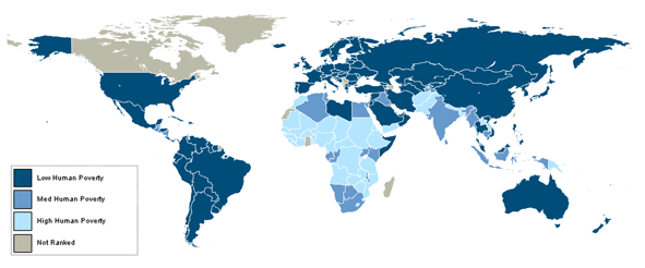
We are all familiar with maps used to depict boundaries at local, national and international level. The shape file of international boundaries shown below can combine with other information of interest to identify worldwide problems providing visualization of the issue. For example, it we take the variable of poverty (based on the human poverty rating), the map below, supplied by the UN, simply groups countries based on their poverty rating, with the lowest group being a different colour to highest group.
However, this is a rather simplistic method and smaller countries with a poverty problem may be overlooked. The Worldmapper project have attempted to fix this issue through the development of human cartograms. The maps produced on their website are equal areas cartograms also known as density-equalising maps. The map is resized appropriately according to the variable being mapped. Going back to the example of mapping poverty, the map would actually look like this:
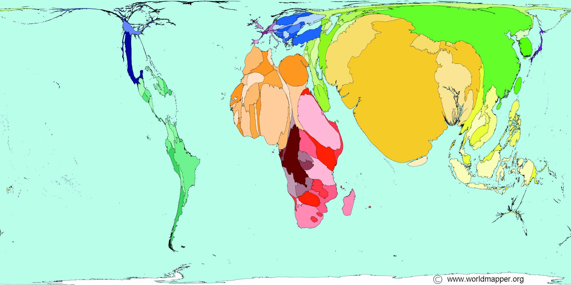
© Copyright Sasi Group (University of Sheffield) and Mark Newman (University of Michigan).
Being able to produce this type of map is very beneficial, especially to policy makers, owing to the problem areas being clearly visible. Free software provided by Scapetoad means you can also create these maps at home!


#Ideas


Next article

Geography a word derived from the Greek word geographia which means earth description has been long considered as one of the fundamental subjects in education system right from the beginning of the system. A subject that is unique in bridging the social and physical aspects of the globe.
 Stories about princes being taught geography when they were young, be it Alexander from Greece or Ashoka from India are well known. It is one of the most important subjects that an educated person and more importantly a future king needed to know. Geography knowledge was seen as a vital to survival and success.
Coming back to the Present – 2013! We see GIS and Location based applications being used ubiquitously.
In India, GIS is being actively employed by the electricity department to keep track of their installations and to help in maintenance. The cops in the country are now getting GPS fitted vehicles to keep track of their resources and help maintain Law and Order. These are just well known applications of “Geography”.
A country of a billion plus people has only a thousand or more Geography / Geo-information graduates coming out of universities every year. There is a tremendous requirement for human resources with very good understanding of Geographic Sciences in the private industry across the globe. All the countries in the world are slowly getting to realize the importance of having geography in the education mainstream. The Indian Planning Commission presented a report in this regard – “The National Task Force on Geospatial Education” which talks about how to help increase Geography awareness in the country.
I’ll leave the how to improve Geography awareness question to the experts, the question that I have in mind –
“Are we correct in categorizing Geography as a social science and not as a Science?”
I strongly believe that it is time that we accept Geography as a science subject. The knowledge of our surroundings is just as important as the knowledge of Physics and Mathematics. Whenever I talk to my friends who are Engineers or Natural Science students, it is hard for them to accept the importance of Geography. I always use the example that Surveying was perhaps the mother of necessity for the development of Mathematics and Science. Humans needed a much more evolved form of numbers and science to be able to keep track of their territories and it is highly possible that this was one of the primary reasons for the development of mathematics. An argument that took it time to be accepted.
A subject that studies physical phenomenons and interaction between different elements cannot be limited to be called “Social Science”. Geography is not just a Social Science, it is Science with a social element to it.
geography science or social science – What do you think? Let us know!