
OpenStreetMap is an amazing project. It gathered a community of dedicated cartographers from all around the world, who voluntarily create and openly share the spatial data to the public. And it many cases OSM does it much better than Google and other commercial maps providers.
Starting this week OSM is getting even better. It now offers A-to-B directions. Lots of third-party apps and services have powered their directions using OpenStreetMap data for some time. Now OSM supports them as well. You can get directions for travel by bicycle, car or on foot. OpenStreetMap team hopes that adding directions will attract more people to actively use and contribute to the project. And we hope they will succeed.

#Business


Next article
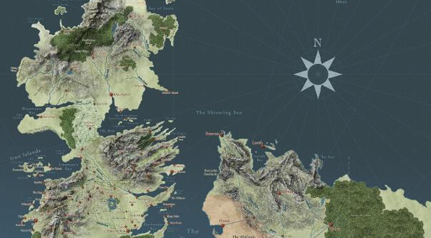

For us geo-nerds, it is important to visualise where events are happening when we read about them. It is especially easy to get disoriented when we are reading about a fictional world that we have ju
st immersed ourselves into. Sure, you can always flip to the beginning of the book to look at the map but that would take you away from the story! If reading historical fiction about the real world, it would be easier to visualise and understand the geographic complexities because we’ve known about real world geography for a longer period time. It’s a good thing that we now have a tool to visualise Westeros.
Fans of the successful series Game of Thrones have gathered to create a Google Maps style interface for users to explore. It is highly interactive and possibly addicting. Find it here.
From political boundaries to character plot lines, you can easily do your own spatial analysis of this complex world and see simultaneous events. You can follow your favourite character geographically on their journeys. Worried about spoilers? It allows you to see the maps episode by episode so nothing will be ruined for you! But nothing is stopping you from taking a peek…
Now, the only thing lacking is Streetview!
Do you think this will help you better understand the world of Westeros? What other fictional worlds would you like to see on this kind of interface?