
Radar images can be used to examine deformations of the land surface. Therefore an area of interest has to be recorded before and after a disruption event presuming the exactly equal orbit and inclination of the sensor. The wave patterns of the two images are combined and turned into a 3d surface. After removing topography, very small deformations (mm) can be detected even within space borne derived imagery. The technique is called radar interferometry (InSAR). It tells how much a land surface moved in relation to the satellite in orbit.
Nepal and particularly the area around its capital Kathmandu were hit by a strong earthquake on April 25 2015. The 7.8 magnitude earthquake claimed over 5000 dead people and affected millions of people living in that area.
For the earthquake in Nepal, Sentinel-1A’s swath width of 250 km over land surfaces has allowed for an unprecedented area size to be analysed from a single scan. Two images taken before and after the earthquake were combined. The resulting interference patterns reveal the extent of deformation, whereas one colour fringe refers to a deformation of around half of the used radar wave length (ca 2,8cm). Thus, colour tapes lying close together imply a high deformation whereas dispersed colour bands refer to less affected surface disruptions. Radar imagery from the Sentinel-1A satellite shows that the maximum land deformation is only 17 km from Nepal’s capital, Kathmandu, which explains the extremely high damage experienced in this area.
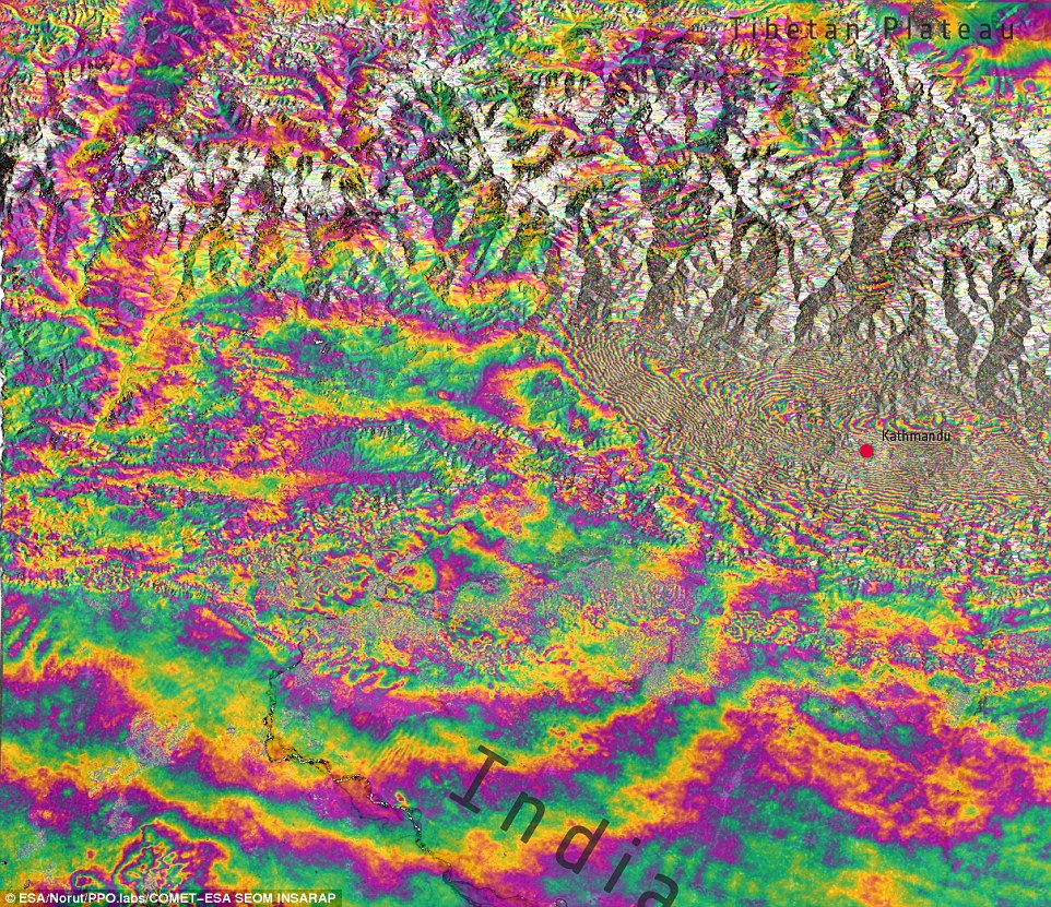
Interferogram over Kathmandu, Nepal, derived from two Sentinel-1A scans on 17 and 29 April 2015 – before and after the 25 April earthquake. Each ‘fringe’ of colour represents about 2.8 cm of deformation. The large amount of fringes indicates a large deformation pattern with ground motions of 1 m or more. Source: ESA
The interference pattern itself does not reveal weather the surface lifted or dropped. Scientists from the German Aerospace Agency (DLR) have used data from Sentinel 1-A to create a map that reveals how much and in which direction the land in and around Kathmandu moved in relation to the satellite in orbit. The map is counterintuitive in the sense that blue colors (negative value) indicate areas that raised, while the yellowish to reddish tone reveals areas that sagged (positive values) due to the earthquake. The map shows that the terrain in Kathmandu raised by around 0.8m, the mountainous area right in the North of Nepal’s capital thrusted skywards of up to 2m! At the same time the mountainous region farther North of Kathmandu dropped by less than a meter.
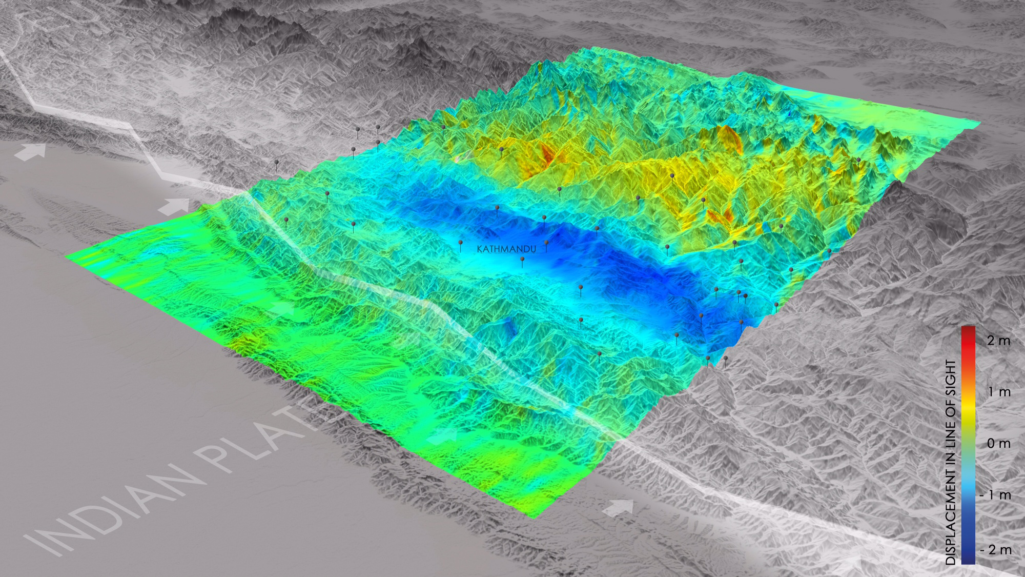
Changes in elevation and position that occurred as a result of the April 25, 2015 earthquake in Nepal are depicted in this image based on satellite data. Areas in blue were raised by about 0,8 meters, the ones in dark blue were lifted up to 2,5 meters. (Source: DLR)
Imagery from the Sentinels and other Copernicus contributing missions are coordinated by ESA to be used by the Copernicus Emergency Management Service (EMS), which supports all phases of the emergency management cycle. Sentinel-1A is the first satellite for the Copernicus environment-monitoring programme led by the European Commission. Its all-weather, day-or-night radar imagery is particularly suited to support impact assessment for many types of geohazards. The satellite is planned to provide systematic observations of tectonic and volcanic areas at global level.

#


Next article

The GEO Illustration Challenge is asking participants to give our planet a new face. The theme is “Transcending Borders – and Changing the Earth’s Image”. From illustrators and designers to keen Photoshoppers, everyone is invited to participate. The grand prize: a VIP invitation to a 2016 ESA satellite launch at Guiana Space Centre near Kourou, French Guiana.
From space, the lines between desert and fertile terrain, populated a nd uninhabited regions, and dense rainforest and cleared land are clearly visible. Indeed, they are what give contours to the very face of Earth. Also evident, but more difficult to construe, are the borders drawn by humankind: between nations, ethnicities, religions, and the wealthy and impoverished.
As part of the 2015 Copernicus Masters competition, GEO magazine is inviting interested participants to apply graphical and artistic techniques to satellite imagery and illustrate them in vivid, artistic ways that reflect the theme “Transcending Borders”.
Participants will receive access to free satellite image data provided by the European Space Agency (ESA) through the competition website. An expert jury will judge every complete submission based on its informative content and aesthetic value.
The submission phase for the GEO Illustration Challenge “Transcending Borders” will run from 15 April to 13 July 2015.
The annual Copernicus Masters competition awards prizes to the most innovative solutions for business and society based on Earth observation data. www.copernicus-masters.com
Copernicus is the most ambitious Earth observation programme to date. By providing accurate, timely, and easily accessible images and data on our planet’s land, oceans, and atmosphere, it is improving our ability to manage the environment, understand and mitigate the effects of climate change, and ensure civil security. http://www.esa.int/copernicus & www.copernicus.eu
Anwendungszentrum GmbH Oberpfaffenhofen – an experienced organiser
AZO has been carrying out the Copernicus Masters competition on behalf of ESA since 2011. By leveraging its extensive experience as a specialist in building and maintaining global innovation networks and organising related competitions, the company supports product innovations and the creation of new businesses, particularly in the field of commercial aerospace applications. www.anwendungszentrum.de