Location awareness without GPS or (indoor) maps? No problem! Navisens thinks it has the answer #TheNextGeo

It’s not often that you come across a geo-startup that has its roots in the PhD thesis of its founder, let alone be mentioned as one of the “50 most promising startups you’ve never heard of (2017)” by Bloomberg. But that is not what makes Navisens, an interesting company. What makes navisens a startup to remember is their technological prowess – their positioning API works with just the inertial sensors in your smartphone and all you need to do to actually see if it really works is check out their demo on their website. Yup, you don’t need an app for that! We spoke to Ashod, their CEO and founder to learn more about Navisens and their story. Read on! [easy-tweet tweet=”Meet Navisens – the startup that believes all you need for location awareness is the inertial sensors on your smartphone. Regardless of whether you are indoors or outdoors!” user=”Geoawesomeness” hashtags=”TheNextGeo”]
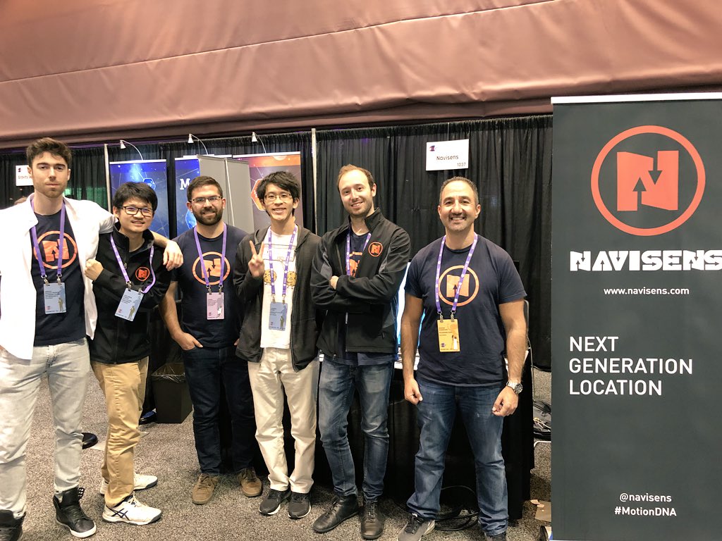
Navisens Team at the Augmented World Expo (AWE)
Q: Ash, let’s get straight into it. Your PhD, which is where the navisens story actually begins, was aimed at locating firefighters inside a multi-story building. What motivated you to do a PhD in this specific topic? What were you doing before that?
A: The story of my PhD which led to the founding of Navisens begins with my undergraduate degree in electrical engineering where I became interested in sensors, real-time embedded software, and Machine Learning (ML). This led to my undergraduate thesis in robotics where I worked on an autonomous Unmanned Air Vehicle (UAV). I gained my first experience with inertial sensors (accelerometers and gyroscopes) and I designed the entire hardware and software system for communication, data acquisition, and control.
My hard work and successful performance in my undergraduate thesis led to the offer of a scholarship for a PhD in robotics where I was based at one of the world’s leading research centres for field robotics, the Centre for Autonomous Systems. I not only completed my PhD, I also qualified to bypass the requirement to complete a Masters degree, so I went straight from undergrad to a PhD. During my journey, I worked as a researcher on projects which very few people in the world have the opportunity to work on, including the 2007 Defense Advanced Research Project Agency (DARPA) Grand Challenge where I was based at UC Berkeley.
In my PhD research, given my background in sensing, machine learning, and hardware and software design, I became interested in the localization problem which is a fundamental problem in robotics. Most indoor localization solutions rely on lasers and cameras. It’s not feasible to mount these type of sensors on humans as they’re heavy and cumbersome, consume a lot of power, and require an unobstructed field of view. This led me to focus on tracking firefighters indoors, which suited the challenge I had set for myself: to track a firefighter without placing any sensors in the environment and without collecting any data beforehand. This is what eventually turned into Navisens.
Q: Unlike many other (indoor) positioning solutions, Navisens does not rely on any additional infrastructure. All you need are the inertial sensors inside a smartphone. But then, how accurate are these sensors and How do you deal with drift and other engineering challenges that come with them?
A: Navisens doesn’t rely on any additional infrastructure and this originates from the background of Navisens tracking firefighters, where it’s not possible to install any infrastructure in a building. Due to that constraint, my PhD research was focused on using only self-contained sensors such as an Inertial Measurement Unit (IMU). Most robotics applications employ an IMU, and I had used several IMUs in many robotics research projects. The key point is that traditional inertial navigation algorithms rely on very accurate sensors. The IMU my team used for the 2007 Defense Advanced Research Project Agency (DARPA) Grand Challenge was ITAR restricted, meaning that the sensor quality is high enough that the U.S. government controls the export of the device as a military-related technology.
Smartphones include mass-manufactured low-cost micro-electro-mechanical systems (MEMS) sensors, which are several orders of magnitude lower quality, and thus traditional approaches and algorithms cannot be used. Navisens handles this with our proprietary algorithms which process the sensor data in a unique way, very different to traditional approaches, and based on what I would call modern techniques such as machine learning and newer robotics algorithms. Our goal is to minimize the drift to be as low as possible such that our location accuracy is suitable for the majority of applications without having to use any external measurements or corrections.
Q: When you talk about a startup that works on positioning with inertial sensors, the obvious question that most people have (at least of late) is – Are you guys also working on autonomous navigation? You were listed in Bloomberg’s “These Are the 50 Most Promising Startups You’ve Never Heard Of”(congratulations), so needless to say that would have also meant that the automotive industry was at your door. So?
A: Thanks, it was great to be listed in the Bloomberg article… I actually didn’t know about it until it was published!
We’ve certainly been approached by automotive manufacturers and OEMs, especially since my background includes a lot of robotics and autonomous vehicle research. In fact, as an academic researcher, I’ve also worked on projects designing sensors and software tools for vehicle dynamics analysis for automotive manufacturers. This puts me in a unique position to understand the field very well.
Firstly, as a founder & CEO of a technology startup, one of the things I’ve learnt is the need to remain focused. Even small distractions or changes in direction can consume resources unnecessarily and can have an impact on your team. Staying focused means that your team isn’t spread thin and you can continue to service and delight your current customers and maintain quality work. In addition to all that, some of the very largest companies in the world (which includes automotive companies) can be a large resource drain on a startup. You always need to be mindful of this as a leader of a startup.
Secondly, as an engineer, there are some significant differences between a vehicular platform and a smartphone-based platform. As Navisens provides a Software Development Kit (SDK) for smartphones, we avoid custom operating systems and an operating system which isn’t iOS or Android. This rules out certain vehicle integrations. Since we’re tracking smartphones which are carried by humans, we don’t have the benefit of a comparatively much more stable platform such as a vehicle, and we don’t have the benefit of knowing the control inputs (e.g. steering, brake, throttle) of a human. Thus, we’re solving an extremely challenging problem, one which requires us to have an extreme focus on technology.
Considering the above, I will mention we are actively in discussions with one or more automotive companies in some capacity 🙂
Q: One of the coolest things that fascinated me the most about Navisens was your demo which is available both as an app (on Android and iOS) and on your website (on iOS devices). I didn’t even know that you could access the inertial sensor data from a website! The motivation for the app is clear but what made you build it into your website. Was it a bet with someone? 😉
A: Although I’m biased, I must admit, it is a pretty amazing demo! As far as I know, Navisens is the first company to be able to perform inertial tracking in the browser! It’s a testament not only to our technology which is able to handle data from low-cost sensors under challenging conditions but mostly to our amazing engineers which are both extremely talented and innovative.
Actually, this wasn’t due to a bet but it was related to the culture of Navisens. We researched and built this for two reasons:
- Supporting a wider range of applications: there are many cool applications that our customers can build with this, and they don’t require their users to download an app!
- Pushing the boundaries of what is possible and continuing to build amazing technology and innovating.
These above points are related to our engineering culture which originated from my research background, and that engineering research mindset continues today and is embedded in the Navisens team. Navisens is an engineering-focused company composed of talented researchers and software engineers. We’re working on many more exciting things and have much more amazing technology developments in the pipeline!
Navisens Cloud (as we call our web API) has many practical applications. Imagine a customer visits your website, searches for an item, and is then guided to the item in real-time, entirely inside their browser. They won’t have to download an app and everything works instantly. This approach can work for retailers, hotels, casinos, university campuses, large commercial buildings, and any indoor or outdoor environment. Navisens Cloud is designed to be used anywhere location can improve the experience for the user without the friction of having to download an app, either indoors or outdoors.
I recently published a blog post on the Navisens blog with more detail about Navisens Cloud.
Q: Your solution isn’t just being used by firefighters. You recently made your SDK public. Prior to that, you were mainly working with enterprise customers. In your opinion what was the most interesting and challenging application where you deployed navisens?
A: We’ve had all types of interesting and challenging applications. One of the most interesting and challenging was in a nuclear power plant. Because the facility is such an electronically harsh environment, many alternative tracking technologies fail due to electronic interference and due to not being able to penetrate through the dense construction materials of the plant. Since Navisens uses inertial sensors our technology performed without any adverse effects. This is contrary to companies which heavily rely on the magnetic sensors (in our experience the magnetic sensors are already very unreliable indoors) or radio frequency measurements (e.g. WiFi and/or beacons). These two technologies are typically very susceptible to interference from motors and large heavy machinery.
Q: More often than not it takes a while to find a business model that works for you and your clients. Have you cracked that code already?
A: We actually signed our first enterprise customer very early in the life of Navisens, and with each additional customer we continue to validate our business model, so we’ve had great success with enterprise deals and business models. As we open up our SDK to a wider range of customers, we’ve focused on a business model which suits self-service customers who don’t have the demands of enterprise customers.
Q: Navisens’ main product is your SDK that allows anyone to use the inertial sensors in a smartphone which obviously means that you are either a great partner or a competitor to the positioning SDKs that Apple and Google have in their mobile operating systems. Any thoughts on that?
A: One of the major advantages of Navisens compared to other location companies is that Navisens works equally well on both iOS and Android. Our SDK has the exact same functionality and identical performance on both mobile platforms. This is great for developers who simply want to learn one API and provide a consistent user experience to their customers regardless of the platform.
Many location companies focus on Radio Frequency (RF) measurements. Usually, this relates to data collection (aka “fingerprinting”) by measuring the signal strength to WiFi APs or Bluetooth beacons. Android essentially provides unrestricted access to these RF measurements, whereas iOS has them completely locked down and restricted. Thus, many location companies perform much worse on iOS compared to Android.
Keeping the above in mind, if we were to partner with either Apple and/or Google, we’d want to maintain our advantage of being a cross-platform technology which works equally well on both platforms. In that case, we’d be happy to partner with both companies!
In terms of either company possibly being a competitor or partner, I believe the background and uniqueness of our technology and the constraints upon which Navisens was founded means our technology focus and our approach is aligned well for a partnership with Google and Apple. Our approach and technology focus is very different compared to Google and Apple which heavily rely on RF signals.
Q: As a startup founder, I am sure that there are many things that you must have learnt along the way. What was the most interesting feedback that you received so far?
A: As a founder, I certainly have learnt many things and continue to learn every day! A founder needs to handle many things. I have an engineering background, so naturally, I’m always interested in and involved in technical discussions and leading our technology roadmap. I also define our areas of focus and priorities, balancing these between our internal technology roadmap and customer-focussed roadmap.
One of the most important roles of a founder is to define the culture of the company and lead the product roadmap, especially early on. A founder is also involved in sales, customer support, recruiting a team, and fundraising. Of course, a founder also has to be a great leader. Each one of these areas has a learning curve.
As a founder & CEO, what I love most is seeing my team working well together, building amazing technology, helping each other, and best of all, being excited about their work and enjoying themselves and having fun. That is the type of environment I will always maintain at Navisens. Some of the best feedback I’ve had is from my team letting me know how much they enjoy all of the above. It makes me happy and proud to have an environment in which people really enjoy and are productive.
I also frequently get interesting feedback from people I meet who say they’re impressed and inspired by what I’ve achieved personally and with Navisens as a company. It’s very humbling to hear that and they actually inspire me with their feedback.
Q: You are based in San Francisco. Needless to say the tech scene there is famous. How’s the geo-startup scene? Are there many investors specifically looking at positioning and other geotech related companies? Are there any local meetups/events that cater to the geo-community?
A: I moved to San Francisco from Sydney Australia to start Navisens specifically because of the tech scene here. It’s a great environment to build technology companies. In the time I’ve been here I’ve seen investor interest peak in several different areas including drones, wearables, Augmented Reality, machine learning, and autonomous vehicles.
In terms of a geo focus, I would say the closest companies are in Augmented Reality and robotics as they both require navigation and sensing. The investors interested in these types of companies are generally the ones which focus on companies with deep technology. There are local events such as meetups and but one of my favourite events is Augmented World Expo (AWE), a conference and expo that Navisens has been attending for a few years now.
Q: Okay, this is a tricky one – on a scale of 1 to 10 (10 being the highest), how geoawesome do you feel today?
A: This is actually very easy to answer – I’m at a 10! One of the key parts to being a founder & CEO is that you have to be energetic and positive most of the time, which isn’t just motivational and supportive to your team, but it helps you deal with the difficulties of running and scaling a technology company. So most of the times I’m at a 10! Plus it’s hard not to be at a 10 with an awesome team and technology!
Q: As a doctorate who made the transition to the industry as an entrepreneur, (A) what is your advice for people doing their PhD and looking to get into the industry and (B) in general for anyone looking to start their own geo startup?
A: There are a few things I did during my PhD which helped me along my journey of starting a company. I’ll discuss these from a PhD student perspective, although I think these apply to anyone founding startup:
- Passion and Vision: During my PhD, I worked side-by-side with several PhD students which were solving extremely challenging mathematical and engineering problems, but they didn’t have a vision and passion for turning that technology into a world-changing invention and product. From day one, as a location technology, I always wanted my research to have the same impact on the world as the GPS. It takes a significant step to translate technology into a practical application, and an even more significant step to turn that into a company. This is where the vision and passion of a founder is paramount.
- Being expressive: As a founder, you need to be able to sell, whether it’s to customers, investors, or recruiting a team. This means being able to discuss your work and what you’re passionate about with people who aren’t other PhD students or researchers. You need to be eloquent and thoughtful in your communication, often in a completely non-technical manner, and often framing your answer in different ways to explain things as intuitively as possible.
- Practical implementation: Because of my electrical engineering background and my interests, I always had a practical mindset for designing and creating technology. I coded both in Matlab (extremely popular for research) and also C++ and I personally wrote the entire Navisens codebase in C++. This meant that I built the first working prototype which I demonstrated in front of thousands of people at Launch (where I was awarded Best Technology) and it also meant that I was able to take the step from pure research to working prototype in a very short amount of time, which certainly helped with building a company and fundraising.
Q: If anyone would like to reach you, what would be the best way to do so?
A: Email is best (ashod(at)navisens(dot(com). I do get a lot of emails, so it’s always best to keep the email short and relevant.
The Next Geo is supported by Geovation:
 Location is everywhere, and our mission is to expand its use in the UK’s innovation community. So we’re here to help you along your journey to success. Get on board and let’s start with your idea…
Learn more about Geovation and how they can help turn your idea into reality at geovation.uk
About The Next Geo
The Next Geo is all about discovering the people and companies that are changing the geospatial industry – unearthing their stories, discovering their products, understanding their business models and celebrating their success! You can read more about the series and the vision behind it here.
We know it takes a village, and so we are thrilled to have your feedback, suggestions, and any leads you think should be featured on The Next Geo! Share with us, and we’ll share it with the world! You can reach us at info@geoawesomeness.com or via social media 🙂


#Business


Next article

One of the most awesome things about Israeli crowdsourced navigation company Waze, which Google acquired in 2013, is that it allows drivers to log real-time incidents into its feed directly. Be it an accident, or a road closure because of construction work, or a speed trap set up by the police – Waze helps you help others with handy nuggets of information.
We are yet to see this level of usefulness in Google Maps, but looks like Google might be doing something in that department. According to Android Police, some Google Maps users are receiving prompts for the confirmation of road closures and construction work. Looks something like this:
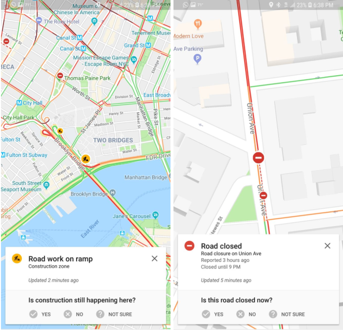
Courtesy: Android Police
So, you can see details of the incident, along with the time it was reported at, and you are given a prompt to verify the accuracy of the information.
It’s yet not clear whether users will be able to report an incident themselves conveniently, because right now, the procedure is quite lengthy. You have to dig deep into the ‘Help & Feedback’ section to report an error on the map and there is simply no provision to communicate temporary incidents, like a road allowing only one-way traffic because of a public event.
So, it’s good that Google is enabling some sort of real-time crowdsourced reporting that would allow Google Maps to suggest alternate routes proactively and save a lot of time and hassle for its loyalists – especially at a time when other players like Apple Maps are working to overhaul their offerings from the ground up.