
A campaign to map the undermapped regions of the world, #map2020, has wrapped-up with teams from Kampala, Uganda, and Erbil, Iraq winning the top slots to present their humanitarian projects at the upcoming HOT Summit in Germany. The campaign was organized by Humanitarian OpenStreetMap Team (HOT) and Mapillary, the street-level imagery platform that scales and automates mapping.
With submissions pouring in from 27 countries including Columbia, Ukraine, Nigeria, and Bangladesh, #map2020 saw 33 mapping teams collecting street-level imagery to address issues like waste management, natural disaster response, and damaged roads in undermapped regions.
The winning projects from Kampala and Erbil submitted over 100,000 street-level images each to tackle humanitarian challenges in their respective cities. Here are the deets…
Facilitating disaster response in Iraqi Kurdistan
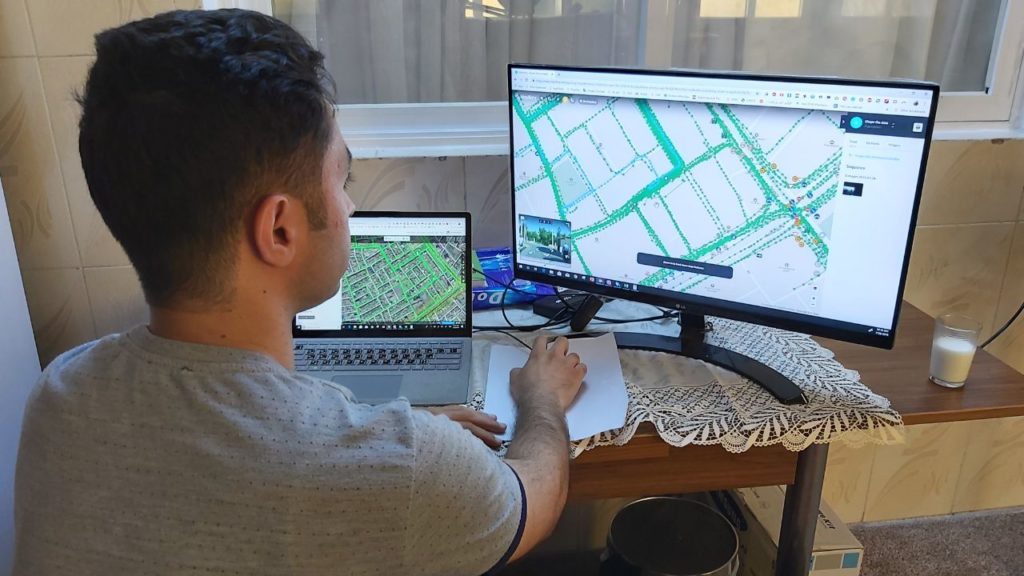
Mohammed Faisal led the team in Erbil
In the capital city of Iraqi Kurdistan, Erbil, a team with backgrounds in humanitarian assistance operations captured over 103,000 street-level images to ensure disaster response agencies had dependable maps during times of crisis. The team focused on pinpointing features like transformers and manholes, and adding details to businesses like pharmacies and supermarkets. Overall, the Erbil team improved OpenStreetMap with almost 400 changesets.
Founder team member Mohammed Faisal is positive the new and improved map will prove to be an important tool for assessing the situation quickly when disaster strikes. “The aim is to provide relief workers with the tools to facilitate the decision-making process,” he explains.
Improving sanitation in slums of Kampala
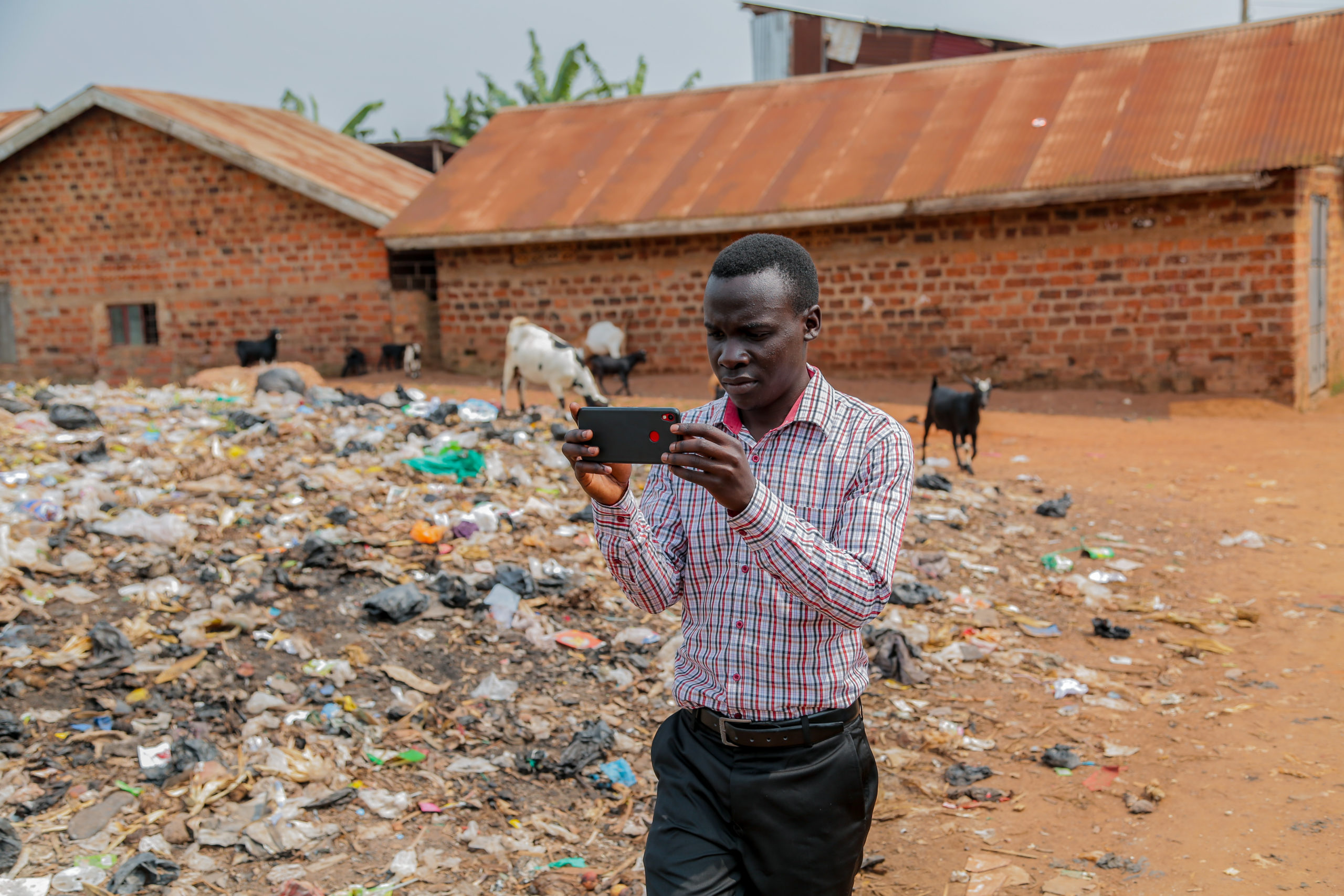
Henry Sseruwagi led the team in Kampala
With illegal dumping of trash being a grave concern in Kampala (especially in slum areas) a student organization called YouthMappers saw #map2020 as the perfect opportunity to highlight the problem to city officials. Covering various regions of the city on foot, the group of volunteers captured more than 110,000 street-level images with Mapillary Android app and added over 50 illegal dumping sites to OpenStreetMap.
The biggest problem the students faced during the course of the campaign, however, had nothing to do with sanitation. It was the lack of reliable internet coverage.
“The internet connection in Uganda is a big problem. We had to let our computers run overnight and then in the morning there would be enough images uploaded,” tells Henry Sseruwagi, who led the project.
While Mohammed and Henry look forward to taking their learnings to Humanitarian OpenStreetMap Team’s global community meeting, HOT Summit, in Germany next month, Rebecca Firth, Director of Community and Partnerships at HOT, hopes that all groups will continue mapping in their areas.
The team at Mapillary, meanwhile, is doubling down to understand which OpenStreetMap tags are most useful for each humanitarian challenge and how data derived from images using computer vision can help to speed up the process.
To see all contributions to OpenStreetMap, you can search with #map2020 hashtag.

#Business


Next article
Geospatial jobs of the week – Cloud to Street, Graphicacy, University of Oregon, and Geospatial Insight are hiring

Are you enthusiastic about location data or anything geospatial, then this is the job portal for you! At Geoawesomeness, we’re working on creating an interactive job portal to connect companies to enthusiastic talent! By the way, we spontaneously post jobs on our LinkedIn throughout the week, so make sure to follow us there!
If your company is looking for new talent and you want to share the opportunity with our community, feel free to submit a job using the online form for us to review and include in our list! If you would like to know more about our Geospatial Job Portal, read about it here.
Here are some of the jobs that are currently available:
Featured Job: Director of Federal Business Development at Cesium
📍Philadelphia, PA USA
Do you have what it takes to help Cesium grow? Cesium looking for a Director of Federal Business Development to own Cesium’s presence in the federal space, including supporting existing relationships and contracts as well as crafting a strategy to find our next federal strategic partners. Sound interesting? Find out more here.
 Featured Job: 2 GIS Developer Positions at the World Food Programme
📍Rome, Italy
The World Food Programme is hiring two GIS Developers! You will support this effort by developing procedures to automatically gather, process and map such information. You will contribute to the maintenance and improvement of the existing infrastructure, and will develop new automatic procedures of GIS data harvesting and mapping. Qualified female applicants and qualified applicants from developing countries are especially encouraged to apply. Want to find out more? More information here.
Featured Job: Web GIS Developer Consultant at the World Food Programme
📍Rome, Italy
In this position, you will support maintenance and further improvement of the Open Source platform and development of other Web GIS application at the World Food Programme. Interested? Apply here.
ESRI: Senior Partner Manager – Emerging Business
📍Multiple Locations, USA
University of Maryland: Post-Doctoral Associate
📍College Park, USA
Graphicacy: Head of Data Visualization Strategy and Engineering
📍Washington DC, USA
Dartmoor National Park Authority: GIS Officer
📍Devon, UK
University of Oregon: Assistant Professor of Geography – Environmental Remote Sensing
📍Eugene, Oregon USA
University of Iowa: Research Associate
📍Iowa City, USA
Geospatial Insight: GIS / Remote Sensing Technician
📍Coleshill, UK
We have so many more jobs in our job portal, and couldn’t possibly fit them all in this blog. If you don’t see anything here for you, go to our job portal!
Are there any specific things you’d like to see in our job portal? Feel free to get in touch.
Want to get your dose of Jobs in Geo directly to your inbox? Subscribe to our jobs newsletter here.