
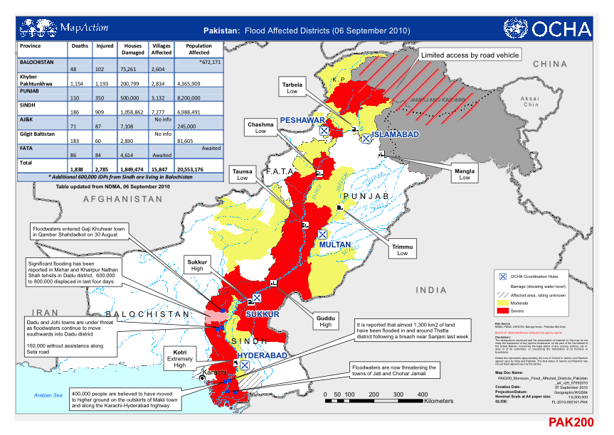
When disaster strikes in any area of the World, one of the first questions that arises is ‘how can we effectively distribute information to mitigate the problem at hand’. Map Action attempt to solve this issue through providing maps such as the one seen below of the September 2010 Pakistan floods.
Map Action is an organisation that are ready to respond 365 days a year with a team of professional GIS experts to create and distribute the required information. Evidently trying to prepare maps in a disaster zone creates several challenges. I recently had an opportunity to speak with a Map Action team member regarding their deployment to Khartoum. I present the interview, which provides an interesting insight into the world of emergency mapping!
What is the main aim of Map Action (for example in Khartoum)?
As always Map Action aims to provide timely situational mapping and information services to any and all humanitarian actors at a major disaster. Khartoum is no different. Map Action received a deployment request from UN OCHA – Sudan and sent a two-person team to be embedded within the UNOCHA in their Khartoum office with the aim of providing operational mapping to aid the flood response efforts in Khartoum and the affected areas in the south and west of Sudan.
What is your specific job within the team, and how do you go about doing it?
With a 2 person team we tend to buddy up on jobs so I might be a robo-mapper (my terminology, not an official MA designation) for a few hours cranking out the maps and digging for data or then perhaps act as a team liaison attending sector meetings, visiting local GIS bods or fielding specific map requests. Everyone pitches in to do what is needed. On those deployments requiring larger teams we can more easily afford to allocate specific jobs to specific people that play to their strengths.
What are the biggest challenges that Map Action face in Khartoum and as an organisation?
One challenge unique to this Khartoum deployment was the restriction on travel (issued by UNDSS) due to the civil unrest in the streets. This caused the cancellation of many of our meetings and hoped for exchanges with UN, NGO and government humanitarian agencies. This curtailment of useful communication was compounded by the citywide withdrawal of Internet access. Naturally, we carried on working with the data available to us from the rooftop of our accommodation. Concerning the larger arena, while I would maintain that every deployment is different there are a few commonalities that seem to pop up every time. Number one (IMHO) is a general lack of geoawareness amongst humanitarian actors in the field and it’s not uncommon to be handed non-georeferenced data. Map Action often gets asked to provide GPS/GIS training for other organisations and we (I) often have to adopt an almost evangelical attitude to get across how mission critical it is to bear in mind the geospatial component when conducting field ops, to drill the idea and importance of georeferenced data/information into heads. This is especially true when training an organisation’s field staff how and when to use their GPS units during field ops.
How do you go about creating the maps? (where do you get data from, is it a collaborative effort, is it done both on location and remotely)
When Map Action gets the green light to deploy, the next immediate action is to initiate the datamining phase. If it’s a country we’ve deployed to before, data holdings are checked and retrieved, if not, the Map Action volunteer pool from all locations swings into action to provide the outgoing team with at least the baseline data they’ll need upon entry to the emergency. While Map Action does indeed maintain a list of data sources that is methodically checked many volunteers might call upon personal contacts within other organisations (e.g. OSM, other agencies operating in country etc…) so yes, you could say that it is a collaborative effort. Once onsite, the members of the deployed team carry on sniffing about for situational data either already held somewhere or for incoming data from returning field teams. Invariably, sometime during a mission you will unexpectedly meet someone holding really useful data. Sometimes Map Action personnel are requested to provide direct GPS assistance for outgoing field teams (I did this for 2 days during my very first mission in 2005 in the rainforest of Suriname for a Red Cross Assessment team). Alternatively, we’ll provide onsite GPS training (or even GPS units) to field teams lacking practical knowledge or equipment of their own.
How have you distributed maps in Khartoum (has there been any specific person who you supply maps to?)
We were embedded within the UNOCHA office so we generally turned over maps to the relevant individuals there for example, the Head of Coordination, Head of Communications or the OCHA GIS bod. Before and after the ban on travel, we printed off several copies of maps for distribution at meetings and briefings around Khartoum. Of course, digital copies were handed out on memory sticks and as always, maps are available for download on the Map Action website (where you can find a complete catalogue of downloadable maps produced at every emergency Map Action has deployed to).
How would you describe your experience of working in disaster zones?
In a word: Rewarding. I get no end of satisfaction from using my GPS/GIS skills in such a directly practical application to help people in need. I also get to work with and meet fantastic people in diverse locations around the world.
Map Action supplies an invaluable source of information to the World and must be commended for the fine service they provide. The organisation is truly a magnificent example of how geospatial experts can work together to develop solutions to worldwide issues.


#Ideas


Next article

Geographical Centre of Gravity?! Isn’t that the same as the centre of gravity? Were the first questions that popped up when I came across this interesting application “The GeoMidpoint Calculator“. But then the GeoPoint Calculator is your personal centre of gravity calculator! It helps you calculate the geographical average location for all of the places you have ever lived, the midpoint in the town for you and your friend to meet, which place should be your base camp if you plan on travelling a lot, so on and so forth!
To calculate your Geographical Centre of Gravity, one has to basically enter the coordinates for places where you have lived and how long you have lived there and voila, your personal centre of gravity is displayed. Wondering how exactly do they calculate your personal centre of gravity – here’s the link . You could also use this application to decide the place where it is bang in the geographical centre for you and your friend to meet up.
I was curious to know what would be the geographical centre of my travel, entered some of the cities that I have visited and looks like that would be somewhere in the middle of the caspian sea! So much for wanting to visit THE centre. Can’t blame a fan of Jules Verne and the Journey to the centre of Earth wanting to travel to the centre can you 😉 But then they helped me decide where to travel next: courtesy an option that generates a random point on the map.
There a lot of cool geography related application that have been floating around the internet and social media and GeoGuessr was definitely one of the most popular games/activities. I’m certain that there will be more such application and activities in the coming times. What is your favourite activity/application that involves geography? 🙂