

To all the Geoawesome people out there! (Well not all, to the citizens of Europe and Africa!)
Here is a great opportuity to make some great money with great ideas that you might have at the back of your head.

Farming by Satellite is a competition for students and young people to come up with ideas on how satellite technology can help improve farming. It is open to everyone irresepctive of their backgrounds and can work in teams of four with a mentor, as long as you are based in Europe or Africa. It is possible to win upto 5000 Euros. (Yeah, three zeros! )
The aim of the competition is to promote the use of the Global Navigation Satellite System (GNSS) in agriculture and its benefits to farmers, consumers, food security and geo-traceability, remote sensing technologies, sustainable land management, and the environment. Individuals or teams can contribute new ideas and innovations, particularly those relying upon the European Geostationary Navigation Overlay Service (EGNOS) and the forthcoming GALILEO system.
You can check your eligibility here and more information on attractive prizes awarded.


#


Next article
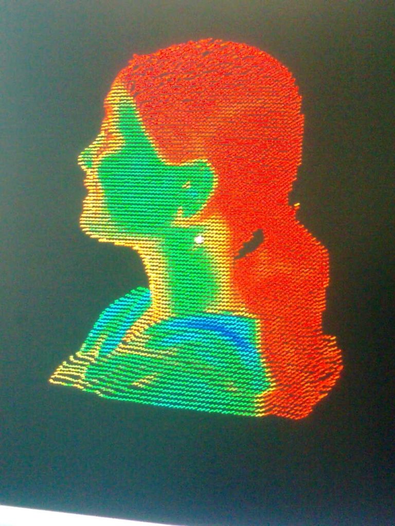
Laser Mapping – a very new concept just few years ago. Today it has found its usefulness from transportation to pipeline mapping to construction. The first time I ever encountered a laser camera was seven years ago, and I was so curious on how it worked, that I made a 3D model of my own head. Yeah, you read it right – MY HEAD!

There you go, the laser model (pun intented!). I was very surprised that the point cloud could actually catch my smile!
Very quickly I started to see the incredible potential of this application beyond mapping one’s own head! Several news pops up now and then about its myriad of uses. It really gets my attention when technology touches the lives of millions, especially in a developing country like India. Street Mapper has set out with a similar goal in mind – to laser map city centers and transportation networks across the entire country.
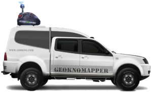
“India is making significant investment to improve its physical infrastructure,” commented Prof Dr. Bharat Lohani, Director and Mr Balaji Nagarajan CEO of Geokno Indian Private Limited , “which is why we are applying the very latest and best mobile mapping technology. One of our primary requirements, and fundamental to the selection of the StreetMapper system, was the requirement for engineering grade survey data. We also needed to be confident in the field performance and reliability of the system to minimise downtime.”
Geokno is a spin-off company from the Indian Institute of technology Kanpur specialising in GIS and related technologies such as LiDAR based surveying. Recognising the technical strengths of the company and the potential of the technology the GMR Group – one of the fastest growing infrastructure enterprises in the country, acquired a majority stake in Geokno.
Developed by UK based 3D Laser Mapping, in conjunction with German guidance and navigation specialists IGI, the StreetMapper system purchased by Geokno included two high speed, non-contact laser scanners specifically designed for mobile mapping as well as an export licence free fibre optic based Inertial Measurement Unit (IMU). The unique pod system also included a high resolution camera, specially designed lifting platform and a custom designed canopy. The newly supplied StreetMapper system can also be used for aerial projects with an airborne mount for the laser scanners and IMU.
Indians, Time to say cheese!