It’s not only the big players like USA, Europe, China, India or Japan that have their own satellites. Even smaller nations make inroads into the world space industry improving the capability to design and develop highly advanced remote sensing satellites. In addition to my last article about satellite-derived bathymetry I want to dedicate some lines to KOMPSAT-3, Koreas high resolution satellite, whose data are used for the sub-meter bathymetry product of EOMAP.
The KOMPSAT (Korean Multipurpose Satellite) program was launched in 1995 with the objective to develop a national space segment in Earth observation along with an efficient infrastructure and ground segment in South Korea, in order to provide valuable services to remote sensing users in various fields of applications. The mission is funded by MEST (Ministry of Education, Science and Technology) and was started with the launch of KOMPSAT-1 in 1999 followed by KOMPSAT-2 in 2006 as the first two satellites of the series.
Like its predecessors KOMPSAT-3 is an optical satellite of KARI (Korea Aerospace Research Institute), but with the so far highest horizontal resolution of the observation mission. KOMPSAT-3 was launched on 18 May 2012 (local time at Tanegashima Space Center of JAXA in Japan) and operates at an altitude of 685 km in a sun-synchronous orbit. Its sensor has 0.7 meter panchromatic and 2.8 meter multispectral (B,G,R,nIR) resolution at nadir. This allows for a 0.7 meter pan sharpened color product and constitutes Korea’s first satellite at a sub-meter resolution.
KOMPSAT-3 was launched to monitor the Korean Peninsula providing high resolution images for Geographic Information System and other environmental and oceanographic purposes. Its high resolution, extraordinary 14-bit depths imagery and afternoon collection times that for some areas will raise the capability to take cloud free images render the satellite an excellent choice for agricultural studies and compliant to imagery collections in the morning. Since 20 March 2013, KOMPSAT-3 imagery is commercially available and distributed by Satrec Initiative.
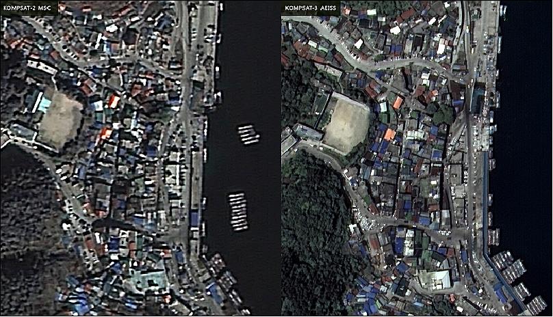
Comparison of an image scene observed by KOMPSAT-2 (left) and KOMPSAT-3 (right). Source: KARI
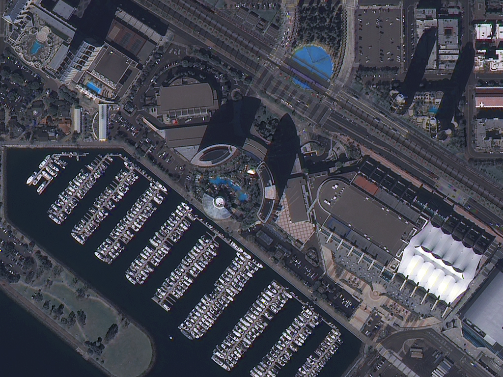
KOMPSAT-3 70cm RGB image of San Diego, California, on 2March 2013. Source: Apollo Mapping
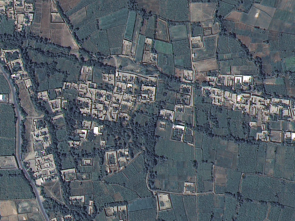
KOMPSAT-3 70-cm RGB image of Bagram Airfield, Afghanistan form 24 August 2013. Source: Apollo Mapping
Performance parameters of the KOMPSAT missions (Source):
| Parameter / Mission |
KOMPSAT-1 |
KOMPSAT-2 |
KOMPSAT-3 |
KOMPSAT-5 |
| Launch date |
Dec. 20, 1999 |
July 28, 2006 |
May 17, 2012 |
2014 |
| Main payload |
EOC (Electro Optical Camera) |
MSC (Multispectral Camera) |
AEISS (Advanced Earth Imaging Sensor System) |
COSI (Corea SAR Instrument), X-band |
| Resolution/swath width |
6.6 m (Pan) |
1 m (Pan) / 15 km |
0.7 m (Pan) / 16.8 km |
1 m / 5 km |
| Orbital altitude |
685 km |
685 km |
685 km |
550 km |
| LTAN |
10:50 hours |
10:50 hours |
13:30 hours |
6:00 hours |
| Spacecraft design life |
3 years |
3 years |
4 years |
5 years |
| Spacecraft mass |
470 kg |
770 kg |
980 kg |
1400 kg |
| Spacecraft power |
636 W |
1.0 kW |
1.3 kW |
1.4 kW |

#

Next article

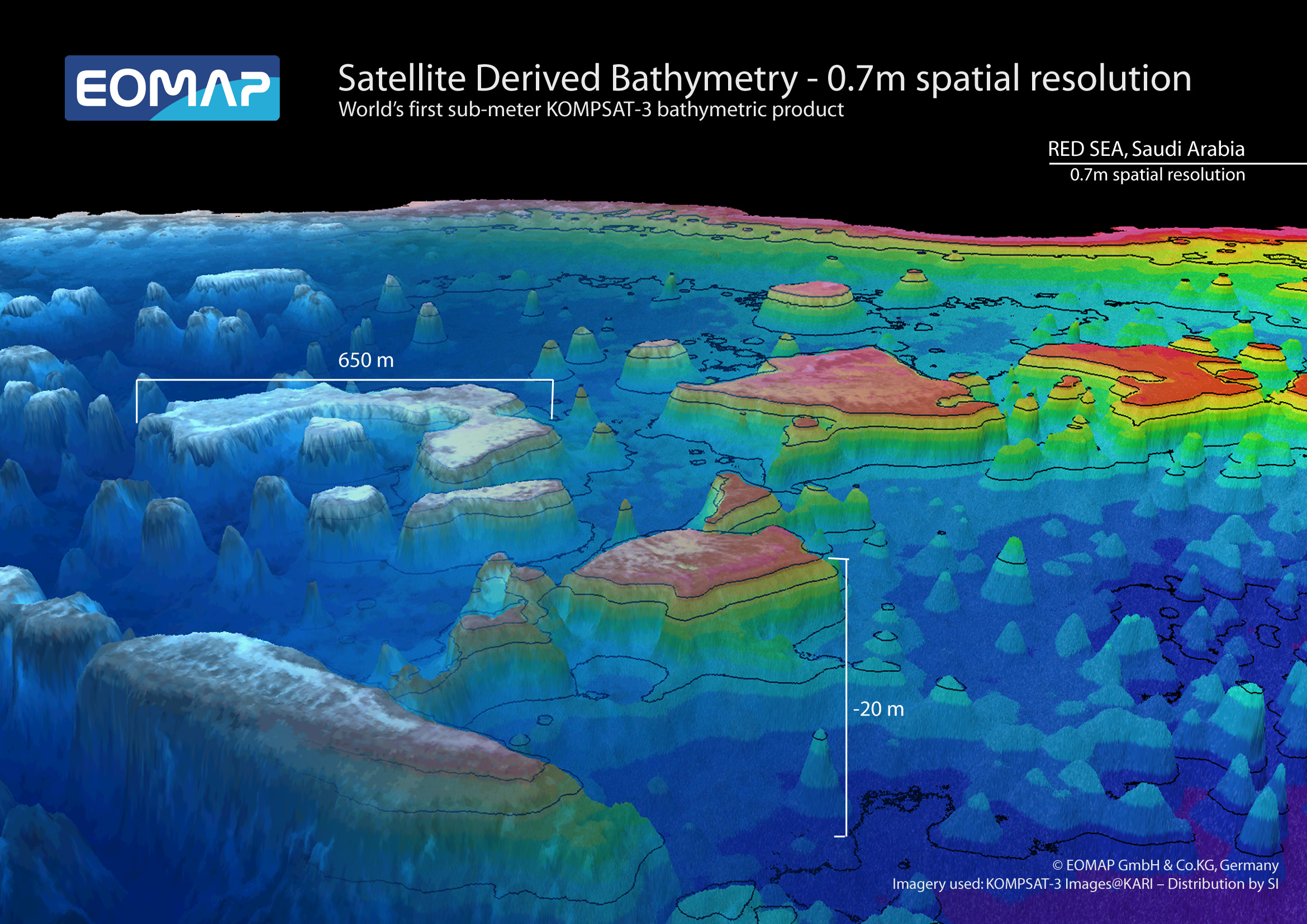
I already reported on the achievements in mapping water depth, seafloor habitats and reef structures that are particularly pushed by the Germany based company EOMAP, leader in satellite-derived bathymetry. So far, the produced products have a horizontal resolution of at most 2 meters. As a next step the company launched the world’s first commercial, sub-meter bathymetry product based on satellite imagery. The product is not an exclusive project by EOMAP, but a cooperation between EOMAP and the Korean company Sartrec Initiative. Why is that? – EOMAP’s submeter product relies on KOMPSAT-3 imagery that are distributed by the Korean company.
The teams of EOMAP and Satrec Initiative have launched the world’s first commercial, sub-meter bathymetry product based on satellite imagery.
“We’ve successfully processed KOMPSAT-3 derived bathymetry for different sites with varying recording conditions. The product quality in terms of spatial resolution, accuracy and signal-to-noise-ratio was a positive surprise to our team. We’re therefore proud to announce that commercial satellite-derived bathymetry (SDB) has now reached sub-meter horizontal resolution, specifically in this case 70cm spatial resolution” explained Dr. Thomas Heege, CEO of EOMAP.
KOMPSAT-3 is a recently launched multispectral satellite, which has the latest state of the art technology to measure the Earth’s surface at very high resolution. It captures more than 300,000 sq km of the Earth surface every day, approximately the size of Ireland and Britain combined.
MoonGyu Kim, of Satrec Initiative commented “We are very pleased with the high quality of bathymetry products that EOMAP derived from KOMPSAT-3 imagery. I believe the new products developed by EOMAP will be a very cost effective and valuable way of obtaining bathymetry data.”
The EOMAP team processed KOMPSAT-3 data and produced bathymetry for study sites at which they had previously derived bathymetry products using other satellite imagery, and for which validation data was available. This enabled both a comparison with other bathymetry products as well as an objective evaluation of the results.
“Our SDB service will strongly benefit from the KOMPSAT-3 derived image data. They can now be used in synergy with other high resolution data in our algorithm workflow. EOMAP is now able to offer low cost and rapid bathymetric data from 30 to 5 to 2 to 0.7m resolution, providing bathymetry layers for every purpose,” said Abhay Mittal, CMO EOMAP.
“Together with the attractive costs of the KOMPSAT-3 imagery we’re confident in providing industry-leading, very high resolution services to our clients and we invite everyone interested to visit us at our booth R110 at the Oceanography International conference, which is being held next week in London“, added Dr. Heege.