Interview with Amir Farhand – Founder & CEO of Mappt – the most advanced GIS Android app

Recently, I had a pleasure to talk to Amir Farhand – founder & CEO of Mappt and Scantherma.
Hi Amir, thanks for talking to us today.
Hi Aleks, thanks for having me.
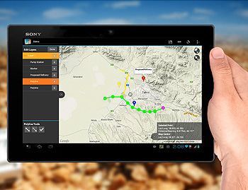
So, what is Mappt?
Mappt is a lowbarriertoentry Android mobile GIS app that breaks away from the traditional dependency on preexisting desktop packages. Mappt seeks to democractise the mobile GIS industry by providing a simple interface, all within a competitively priced package that is easily deployable to field teams.
I’ve seen plenty of different GIS related apps, what’s different about Mappt?
Mappt is trying to break the mould of the traditional GIS app some are either an extension of n existing desktop solution, while others (although independent) are low on features and very specific. We have put many features into Mappt, but at the same time have maintained the most open possible platform to allow users the lowest barrier to entry. We expect users to be able to pick up an Android tablet, download and install Mappt and use it within five minutes. Better still, if your data is on Google Drive or on an SD Card, you can directly import it into Mappt ‘on the go’ making it perfect for offline use. Furthermore, Mappt also has no ‘iTax’, which means you don’t need a specific hardware type to use it. It works on almost all Android tablets running 4.1 and up.
Who are your customers?
Since we’re based here in Perth, Western Australia, it was easy to find mining customers. We focused on what we knew best, and given that Scantherma has a strong foundation in the remote sensing industry in Australia, this was the perfect place to start. Companies such as Samsung, C&T and SinoSteel have been great supporters, especially early on. Now, Mappt has grown to include customers from a variety of different industries and from different countries; ranging from energy and agriculture through to environmental protection and NGOs. Most interestingly, we have even worked on customised versions of Mappt, such as a version called ‘Fire Tracker’ for Raindance Systems who build helicopter incendiary systems for fire mapping and management.
What’s the business model behind the Mappt project?
We’re still in startup mode and really want to shake the mobile GIS industry up. First and foremost, our aim is to democratise the mobile GIS industry by allowing more people to access this technology in a way that can really impact how they go about their every day tasks. This is important to us because traditionally GIS technology has been limited by the cost of both hardware and software. Mappt on the other hand is inexpensive and better still, its 100% useable with even cheapest Android hardware. During my time as CEO of Scantherma, Ive seen many cases where it was hard to get technology into the hands of the people that could really use it, and even harder because sometimes they could not necessarily afford it. With Mappt we want to give the same level of expertise and ability to someone in a developed country, as we do to those in developing nations.
Over last two years (when I’ve first seen it) the app has developed significantly. Where are you right now? What is your vision on where you to be with Mappt?
This has been propelled mostly by market forces and the fantastic support we’ve had from vendor independent companies. We have received a lot of support in implementing specific features that clients required in order to best fit into their business operations. Right now we’re concentrating on refinement, but by mid 2015 we hope to have embedded additional features such as WFS/WMS support, photo geotagging, geodatabase support as well as CAD/DXF data importing. The vision within the next 2 years is to release a full SDK/API, and open Mappt up to customised development by our users. Again, we want to democratise the mobile GIS industry with Mappt; and this ‘expansion pack’ will allow for this to occur.
You’ve manage to transform you idea into business. Please give some hints to our Geoawesome readers who would also like to transform their own ideas into real-life project.
Having lived and breathed the ‘startup’ entrepreneurial culture for most of my life, I would have to say you need to be extremely focused, goal orientated and even a little stubborn with your ideas and dreams. For innovation to happen we often start by asking ourselves what is the solution to the problem, then we work backwards; but sometimes these solutions are never materialised due to commercial forces. As innovators we sometimes need to be diligent in separating our products between who our users are and who our clients are (i.e. who is going to pay for our products?). I feel that through commercialisation, true innovation can really grow and inturn provide better solutions, and inevitably growth.

#Ideas


Next article
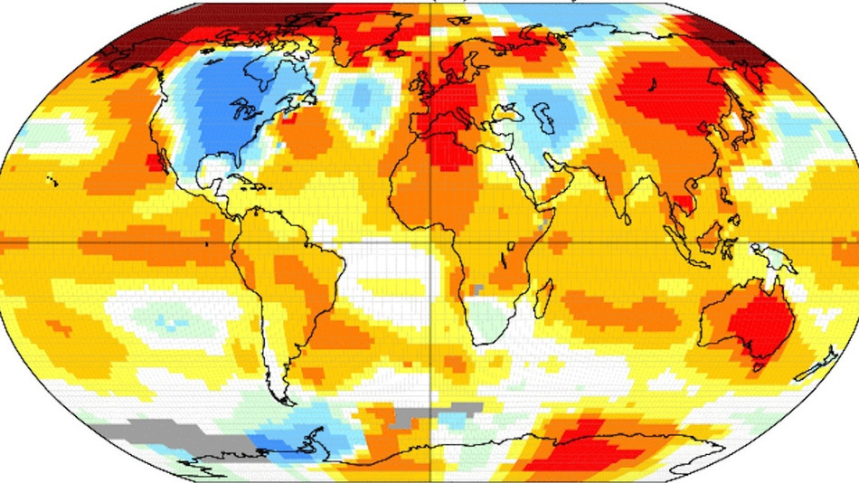
Scientists claim that we have experienced the warmest year on our planet since instruments started to measure temperature and very likely for at least 4,000 years before that.
The map below shows the global temperature anomalies in November 2014 compared to the average from 1951-1980. The global average surface temperature’s are 0.65 degrees Celsius (1.17 Fahrenheit) above the average.
Are you still not convinced that the climate is changing? Look at that chart which shows the fact that 14 out of the 15 warmest years have all occurred since the year 2000.
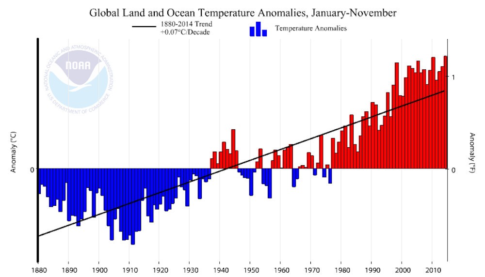
Of course the climate on Earth is largely driven by the oceans. All previous record holders had a natural support of El Niño events. This year’s record didn’t.
Is it just a temporary situation or a long-term trend? We don’t know yet but it starts to be hard to believe that the global warming is just a myth.
source: Mashable