
 Being an editor at Geoawesomeness gives me not only the possibility to share cool stories with GeoGeeks from all around the world, but more importantly it lets me to talk with awesome people who are shaping the future of the geo industry. Recently I had a pleasure to meet Anna Broberg, CEO of Mapita – the Finish start-up standing behind Maptionnaire – an online tool for quick and easy creation of map-based questionnaires. Here is what we’ve talked about:
Hello Anna. Thanks for taking your time to talk with me today.
Hi Aleks. It’s a pleasure.
Ok. So let’s start from the beginning. What is Maptionnaire? What’s the idea behind it?
The name Maptionnaire comes from the words map and questionnaire. We envision that when the user interfaces and data output are well thought out, it becomes cost-efficient to bring mapping to fields where it is currently not applied systematically. An ambitious mapping project with a big target audience currently requires a considerable number of working hours by software developers. We provide a service that lets anyone create a highly specialized map-based questionnaire. By highly specialized we mean that it’s not just a comments section on a map, but a full-fledged survey and communication tool on a map.
We started out with map-based questionnaires in urban planning and design. For example when new stuff is coming to some neighborhood, the architects could ask the locals questions about the good and bad things in that neighborhood. Quite similarly you could ask workers about their offices, or students about their schools. Or you could ask hikers to evaluate national parks. We firmly believe that the everyday users of any environment have a lot to say that someone should be listening to. And people are willing to contribute, some of our biggest projects have gathered over 30,000 responses.
The benefits of GIS are probably quite obvious for many Geoawesomeness readers. Some of them could probably even implement a questionnaire using Google maps or a similar service. However, Maptionnaire is full-featured, it is mature and well-tested, and it lets you concentrate on the content. Your project will be up and running immediately, instead of spending a lot of time coding and debugging -essentially re-inventing the wheel.
Being the first one is not easy. You have created an internally new market segment, how did it evolve over time?
Our company has its roots in academic research on perceived quality of environments. A field that’s essentially trying to answer questions like “Where are people happy, sad, relaxed, nervous, etc.?” and “Where do they do the things that they do?” Many things have changed since we moved from the academia to the commercial sector, but our slogan is still “When you need to ask where”. Starting the business was a response to the demand on the market: when public institutions in Finland heard about this kind of research, they wanted to apply our mapping methodology to their planning and participation challenges.
Being first is not easy, as you mentioned, and I feel that the full value of map-based participation and information gathering has lately been understood more and more in many sectors.
Who are your key customers and what is your business model?
Our customers are cities and municipalities, consultancies working with land use planning, universities and research institutes, real estate and construction companies, and generally organizations who have the need to ask the users of places and spaces “where”.
Maptionnaire is a SaaS software, and we offer project-based or ongoing licenses to our customers. Obviously we also help customers in designing their surveys, analyzing the data and support their processes, if need be.
Are cities and organizations ready to effectively use spatial feedback from citizens, users, and customers?
An important factor of productivity is also that Maptionnaire is easy to use for people without a background in GIS. The person who needs the questionnaire data is usually not an engineer: they can be a communications specialist, a marketer, an architect, you name it. That’s why our built-in analysis and visualization tool can be used to understand the data in-depth even if one has never heard about coordinate reference systems.
The will to use spatial feedback is increasing all the time, and to help our customers further, we’ve built internal analysis tools to Maptionnaire and thought about the way the data is stored and presented very carefully, to make the analysis and use as easy as possible.
Do you see differences in how people interact with map questionnaires and in general spatial information around the world?
Web maps, like Google maps, are paving the way for companies like us. People are nowadays used to using web maps, whereas we needed to give detailed instructions for use when we started. Often we are asked if for example children are able to use our tools, but actually they are the best at drawing routes accurately.
Maptionnaire seems to be a very advanced platform. Where are you right now and what is your vision for the future?
Recently, we have been working on projects limited to fairly small areas that include some indoor spaces as well. For example focusing on university campuses where the buildings consist of several overlaid floorplans. This kind of very precise data reveals the most loved and hated places to real estate managers, or can be used to brainstorm ideas for improvement. Maptionnaire can also be used to talk about forthcoming developments within a small group of stakeholders: it’s very handy to have discussions categorized under locations marked on a map when you need to return to those discussions many months or even years later.
You’ve managed to transform your idea into a business. Please give some hints to our Geoawesome readers who would also like to turn their ideas into real-life projects.
I think the essential thing is to start working with real-world customers as soon as possible. That is the way to understand the customer need and to become better in what you do.

#Ideas


Next article
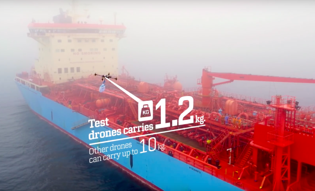

Photo credit: Maersk
Maersk – the Danish sea freight shipping giant has announced that it performed an interesting trial. It used a drone to deliver a package to one of it’s ships around Kalundborg in Denmark. The trial involved dropping a small parcel a couple of meters down onto the deck of a ship using drone made by a French company Xamen.
Technologically speaking it’s not a big deal. In fact you could do it yourself using a few thousand dollars drones but it is an interesting proof-of-concept for yet another usage of drones. Maersk operates a large fleet of cargo ships and tankers. When a ship needs spare parts or mail delivered to workers, the company must send out a small boat to bring the goods from the shore.
“Costs for a barge are on average USD 1,000 and can easily go up to USD 3,000 or more” says Markus Kuhn, Supply Chain Manager at Maersk. “With the current pay-load of drones, on average a vessel has 3 cases per year in which the barge transport could be substituted by a drone – meaning a potential avoidance of barge costs of USD 3,000-9,000 per vessel per year. And if you consider that Maersk Tankers has around 100 vessels, the savings potential could be substantial.”
Maersk isn’t the only company exploring the use of drones for delivery. In 2017 Google and Amazon are planning to launch an autonomous drone shipment services. Interesting times we leave in.