
Interplanetary Navigation and Positioning using Pulsar Signals
The need for “Global” positioning in Space has been a long standing and tricky issue. To put it simply – Outer Space Navigation is yet to replicate the success and confidence GPS/GNSS has had when it comes to Global Navigation on Earth. Well, at least the Star Trek needs this 😉
I have always wondered how they keep tabs on a spacecraft bound for Saturn or even moon where our GPS/GNSS does not exist. The usual method revolves around radio waves – a spacecraft’s distance from the control station is computed using radio waves which I understand is accurate to within a meter.
When it comes to Outer Space positioning, its more about getting the Angular position correct than the radial distance. Current technology has the ability to track angular position with an uncertainty of about 4 Kilometers/astronomical unit of distance between the spacecraft and earth. That’s about 500 Kilometers if your spacecraft is near pluto. Not bad you might think – but surely scientists would be happier to have a better way of determining the spacecraft’s outer space position.
Thats where Pulsar Signals come into the picture.
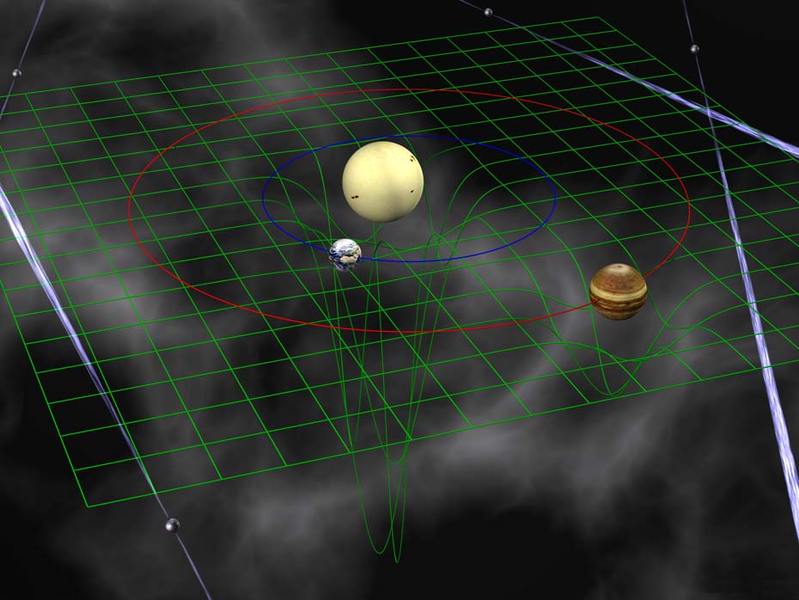
The basic idea behind this interplanetary navigation system is to use the signals from these pulsars in essentially the same way that we use GPS satellites to navigate on Earth. By measuring the arrival time of pulses from at least three different pulsars and comparing this with their predicted arrival time, it is possible to work out a position in three-dimensional space. (Since pulsars produce a stream of identical pulses, it is possible to generate any number of ambiguous solutions when doing this. But Becker and co point out that these can be eliminated by constraining the solutions to a finite volume around the assumed position.)
The man behind the idea Werner Becker, Max-Planck Institute for extraterrestrial Physics in Germany and his colleagues have said that this technology can help locate the spacecraft within a five kilometer radius.
The feasibility of such a system depends on a number of important practical factors, largely determined by the wavelength of the pulsar radiation that the navigation system is designed to detect. This determines the antenna collecting area, the power consumption, the weight of the navigation system, and of course its cost. Becker and co calculate that for 21-centimeter waves, the spacecraft would require an antenna with a collecting area of 150 square meters. But a better idea, they say, is to use pulsars that emit x-rays since the technology for collecting and focusing x-rays has improved dramatically in recent years. SOURCE: Technology Review
The research”Autonomous Spacecraft Navigation with Pulsars” had been published in MIT Technology Review last month.
Taking Navigation to Infinity and Beyond 😉


#


Next article
Copernicus Masters 2013: Earth Monitoring Competition to award EUR 335,000 in prizes and Satellite data
The European Geomatics environment is really something I envy. If the European Satellite Navigation Competition held earlier this year was about getting crowned as the Galileo Master for coming up with innovative ideas for utilizing Europe’s own GPS i.e. GALILEO, the Copernicus Masters is all about remote sensing!
The European Earth Monitoring Competition Copernicus Masters is rewarding ideas and innovative solutions benefitting business and society based on Earth observation data. Entries will be accepted in nine categories from 1 June until 15 September 2013. This year, the BMW Group Research and Technology has joined the competition as new supporting partner, with its “ConnectedDrive” Challenge.
![]() You can actually target any one of the nine challenges (I like to call them opportunities) that the Copernicus Masters has on offer. Here’s where you can get more information regarding them.
You can actually target any one of the nine challenges (I like to call them opportunities) that the Copernicus Masters has on offer. Here’s where you can get more information regarding them.
What makes the Copernicus Masters unique and happening is the variety in the challenges that it offers.
I can’t recall any Satellite Remote Sensing Competition having a challenge where the participants can use their artist skills; I am talking GEO Illustration!
Participants in the GEO Illustration Challenge “Traces of Humankind” will be asked to reveal and illustrate humankind’s footprint on our planet – including all manner of effects produced by both current and long past developments – in vivid, artistic ways based on satellite images. But sadly only European Citizens are eligible for this particular GEO Illustration challenge. The main reason why I envy the European Geomatics Environment!
My personal favourite among the nine “opportunities” is the BMW Challenge. BMW has been focussing quite a lot on the connected car concept – in fact, Aleks wrote about it this morning, so in a sense there are no surprises that “The BMW ConnectedDrive Challenge will reward the best idea that either brings a thrilling new service into the car using Copernicus data or unleashes novel business potential using crowdsourced, high-value Earth-monitoring data”
Cant blame me for being biased towards navigation 😉
BMW’s connected drive challenge
There’s an App challenge for all the android and iPhone programmers, the High resolution challenge for the “loyal” remote sensing enthusiasts .
Well that’s enough of me taking about the challenges 🙂 Good Luck with your ideas!
All hail the Copernicus Competition!
Copernicus?! Well, actually the European Satellite Navigation Competition was aptly called the GALILEO master after EU’s GNSS system. The Copernicus was something I had to dig deeper to find out. The former Global Monitoring for Environment and Security which is one of EU’s grand satellite programs was renamed as Copernicus in 2011. In short, its the European Earth Observation Program.